|
|
|
|
|
|
| |
| |
|
|
|
|
| |
| |
|
|
"Bald Eagle" <cre### [at] netscape net> wrote:
> So, I'm trying to take the face subdivisions from a QuadSphere and uv-unwrap
> them so I can overlay it on an image map.
>
> I tried generating cartesian corner vertices, converting to spherical
> coordinates, and then just plotting those theta and phi angles on the x and y
> with faux-sphere-sweeps for the horizontal and vertical coordinates, and got
> some odd results.
reworked the code a bit, and that didn't help any. Then I switched over to f_th
and f_ph instead of whatever I was using to convert from Cartesian to
latitude/longitude.
That fixed things nicely - almost.
A have some straight horizontal lines now that create "extra" latitudinal
lines/circles. So I'll have to puzzle out the origin of those. net> wrote:
> So, I'm trying to take the face subdivisions from a QuadSphere and uv-unwrap
> them so I can overlay it on an image map.
>
> I tried generating cartesian corner vertices, converting to spherical
> coordinates, and then just plotting those theta and phi angles on the x and y
> with faux-sphere-sweeps for the horizontal and vertical coordinates, and got
> some odd results.
reworked the code a bit, and that didn't help any. Then I switched over to f_th
and f_ph instead of whatever I was using to convert from Cartesian to
latitude/longitude.
That fixed things nicely - almost.
A have some straight horizontal lines now that create "extra" latitudinal
lines/circles. So I'll have to puzzle out the origin of those.
Post a reply to this message
Attachments:
Download 'cubesphere_uvgridmaker.png' (186 KB)
Preview of image 'cubesphere_uvgridmaker.png'
|
|
| |
| |
|
|
|
|
| |
| |
|
|
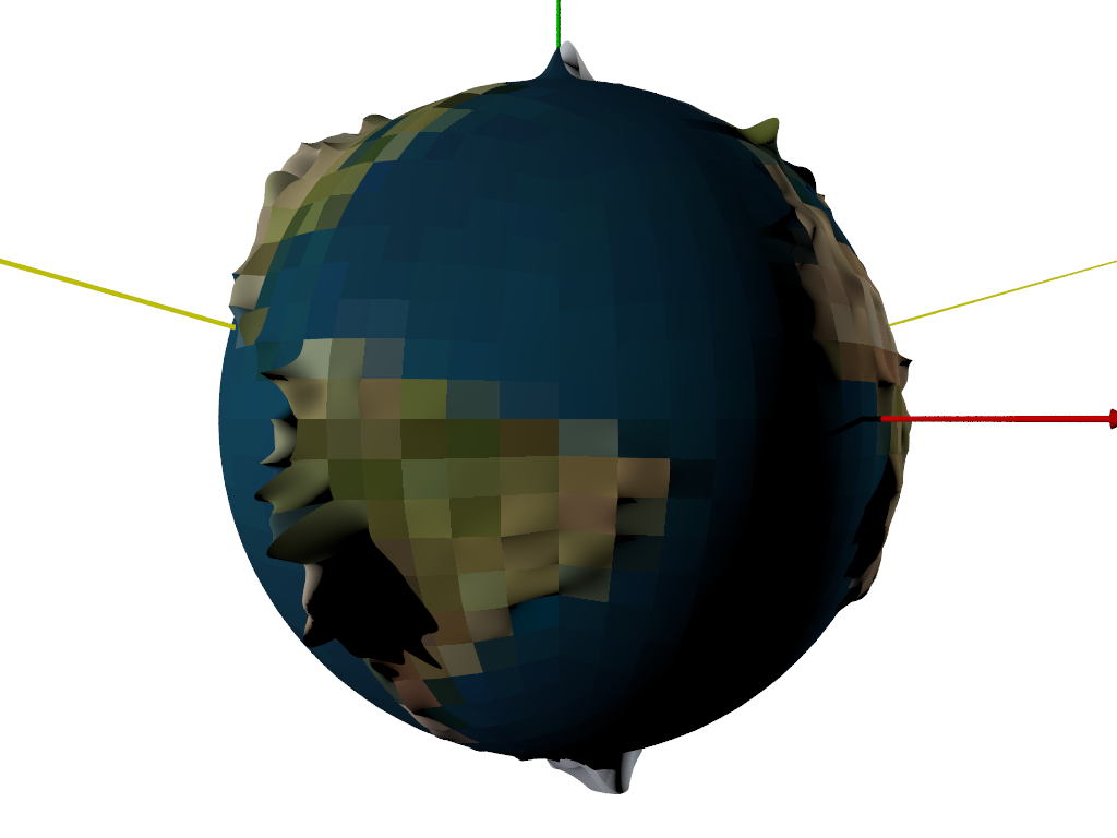
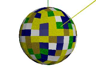
Update:
My man jr and I have discussed the many aspects of this at great length, and
I've formulated a suite of files to generate the framework of the planet and
create tiles as separate include files.
Some more work needs to be done in order to create some DEM-style terrain, but
at the present time, all of the "parts" successfully work to render the planet.
The idea here is that although a huge number of tiles may be needed to render
all of Earth, the likelyhood that anyone will need to accurately and
realistically render all of the areas of Earth covered in water, ice, sand, or
forest is --- low.
So the "engine" looks for existing tile definitions, and when nothing is there
(zero data storage), a default texture is rendered.
The include files are "autonomous" in the sense that they are included to
provide content for the region they describe, and the engine need not worry
about it.
jr has worked out and written a lot of QuadTree code, so once some more
development has occurred, we'll start experimenting with tile subdivision, and
distance-based Level Of Detail (LOD).
So, a .pov file takes the number of subdivisions of each face of the QuadSphere
and uses that metric to create NxNx6 include files. They are currently randomly
textured based on a randomly generated biome type that is defined in it include
file. The plan for later is to scan a global image map and make a rough
assignment of tile biome type based on that.
That will essentially take care of 89% of the planet, and leave 11% of the
planet where something of interest might actually be.
Individual tiles can be created/copied, subdivided, and edited to add things
like oil platforms in the middle of the ocean, TdG on an arctic ship, or
anything else, wherever one might like.
The attached proof-of-concept image is 8*8*6 = 384 individual include files,
automatically generated, and without any user-added content.
Post a reply to this message
Attachments:
Download 'myplanet.png' (355 KB)
Preview of image 'myplanet.png'
|
|
| |
| |
|
|
|
|
| |
| |
|
|
Op 11/07/2020 om 23:51 schreef Bald Eagle:
> Update:
>
[snip]
As you are aware, this is a view of the planet Quilt in the Fomalhaut
system ;-)
I am following this work with interest. You are making good progress indeed.
--
Thomas
Post a reply to this message
|
|
| |
| |
|
|
|
|
| |
| |
|
|
Thomas de Groot <tho### [at] degrootorg> wrote:
> As you are aware, this is a view of the planet Quilt in the Fomalhaut
> system ;-)
You certainly do keep abreast of topics astronomical, don't you..
IIRC there was a sci fi novel about a "planet" made of stolen shards of other
planets all cobbled together... can't recall or find it...
> I am following this work with interest. You are making good progress indeed.
Thanks - the key idea is that it's going to be very much like a particle system,
where the engine doesn't control the particles - the particles direct
themselves.
So one can add, delete, or modify an include file (within the given
constraints(?)) and you can still render an entire planet - straight "out of the
box" or even if the only thing you've modeled is the Eiffel tower - or a sphere.
Post a reply to this message
|
|
| |
| |
|
|
|
|
| |
| |
|
|
Op 12/07/2020 om 13:12 schreef Bald Eagle:
> Thomas de Groot <tho### [at] degrootorg> wrote:
>
>> As you are aware, this is a view of the planet Quilt in the Fomalhaut
>> system ;-)
>
> You certainly do keep abreast of topics astronomical, don't you..
>
> IIRC there was a sci fi novel about a "planet" made of stolen shards of other
> planets all cobbled together... can't recall or find it...
>
Hmm... I don't recall that one for the moment.
>> I am following this work with interest. You are making good progress indeed.
>
> Thanks - the key idea is that it's going to be very much like a particle system,
> where the engine doesn't control the particles - the particles direct
> themselves.
> So one can add, delete, or modify an include file (within the given
> constraints(?)) and you can still render an entire planet - straight "out of the
> box" or even if the only thing you've modeled is the Eiffel tower - or a sphere.
>
Yeah! That opens up really interesting perspectives. My (long-dormant)
Gancaloon world would perfectly fit the picture.
--
Thomas
Post a reply to this message
|
|
| |
| |
|
|
|
|
| |
| |
|
|
A bit more progress:
Got the cartesian to spherical to uv conversions worked out, used the mapping to
look up altitude at any given point, and have bezier arrays for each of the
tiles. Using the mapping to sample the center rgb value of a tile from a color
world map gave me a rough value which hopefully may be used to automate terrain
designations and texture definitions.
I overrode the random format assigned to the tiles, and made them all bezier
patches - about 1500. Elevation is greatly exaggerated (x300). Can render as a
wireframe of bezier splines, and still have to work out how to generate the
appropriate heightfields from the world map for the individual tiles.
Post a reply to this message
Attachments:
Download 'myplanet.png' (137 KB)
Preview of image 'myplanet.png'
|
|
| |
| |
|
|
|
|
| |
| |
|
|
Bald Eagle wrote on 30/07/2020 12:59:
> A bit more progress:
>
> Got the cartesian to spherical to uv conversions worked out, used the mapping to
> look up altitude at any given point, and have bezier arrays for each of the
> tiles. Using the mapping to sample the center rgb value of a tile from a color
> world map gave me a rough value which hopefully may be used to automate terrain
> designations and texture definitions.
>
> I overrode the random format assigned to the tiles, and made them all bezier
> patches - about 1500. Elevation is greatly exaggerated (x300). Can render as a
> wireframe of bezier splines, and still have to work out how to generate the
> appropriate heightfields from the world map for the individual tiles.
>
More and more interesting...
Paolo
Post a reply to this message
|
|
| |
| |
|
|
|
|
| |
| |
|
|
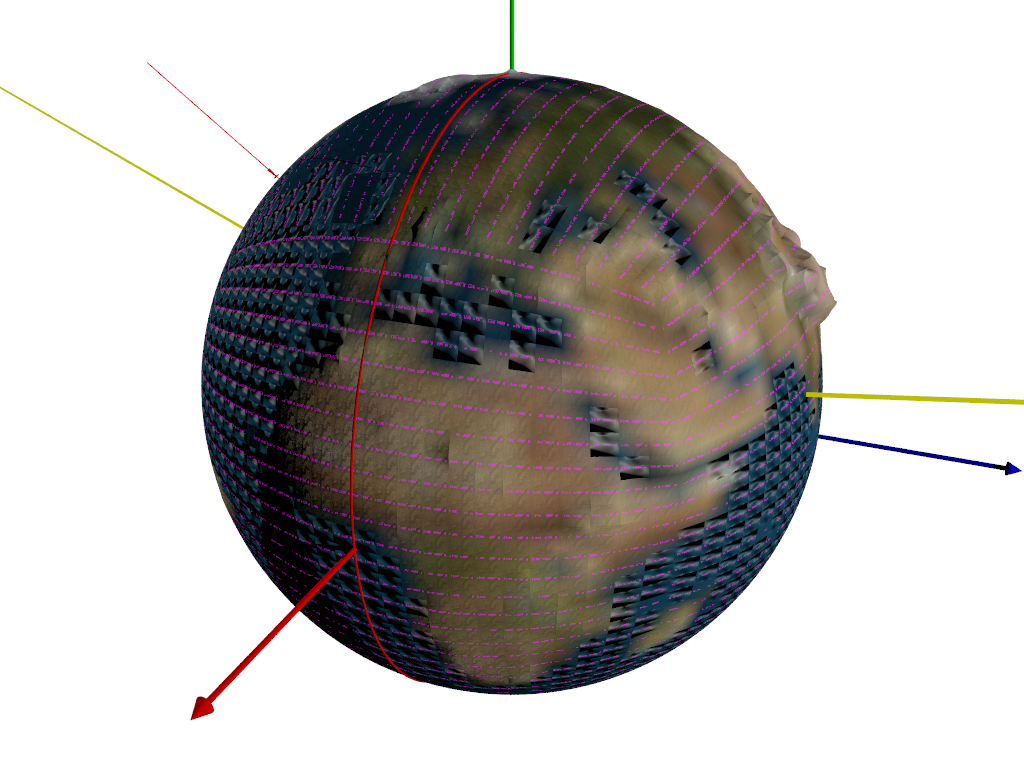
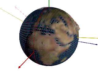
I managed to code most of the "user-side" of the project, where the customized
options and scene description for that tile region gets stored. All of the
infrastructure gets generated and stored, and tiles get enabled by renaming from
..tmp to .inc
Presently I just have a simple user-defined checker texture that can be
uv-mapped on the terrain for that tile.
I need to adjust my world image_maps so that the Greenwich Prime Meridian is at
x=0, and then do some verification that all of the lat/long calculations are
correct.
I'm thinking about how to partially uv-map a tile with a map or satellite data -
probably an image_map once and some scaling.
The map square shown is just a double triangle textured with an image_map, and
it floats in space.
The whole thing gets pre-generated in a very short amount of time (1500 tiles)
and renders extremely quickly.
I need to smooth out the bezier seams then begin to work on how to tie in
subdivided tiles of different levels of detail.
Also some mechanism for determining which files need to be edited given a
certain view would be a huge step forward in terms of ease-of-use.
Post a reply to this message
Attachments:
Download 'myplanet.png' (146 KB)
Preview of image 'myplanet.png'

|
|
| |
| |
|
|
|
|
| |
| |
|
|
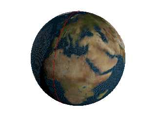
OK, got my image map oriented, and have a Prime Meridian indicator.
I have a macro for determining what tile includes a given point, so the proper
file(s) can be edited.
Got rid of relative filenames.
Need to tweak the implementation a bit, using the ini and shell command stuff.
I have uv_mapped tile numbers, and I fixed the Bezier array so that it uv maps
the correct way.
(was thinking maybe checkerboarding the tilename colors and/or orientation +/-
45 deg)
Added prefixes Planet_ and User_ to tile filenames on either side so that they
are easily differentiable without knowing the path (like looking at the filename
in an editor) ;)
Moved the tile generator and the tile index file into the PlanetCode directory
so that they're not mixed in with the tiles.
Reworked my bilinear interpolation macro into a function, and used that to
create a function pigment in order to take the pigment at each of the 4 corners
of a tile and interpolate the rest of the tile.
Added normals, and finishes with some control variables.
Parse - 7 seconds
Render - 11 seconds.
24 x 24 tiles per face = 576 * 6 faces = 3456 tiles.
Post a reply to this message
Attachments:
Download 'myplanet.png' (535 KB)
Preview of image 'myplanet.png'
|
|
| |
| |
|
|
|
|
| |
| |
|
|
So, even with the not-working normals, it's starting to look pretty good.
This is the "full" 48,000 basis-tile planet which will have (6?) levels of
subdivision created on an as-needed basis.
Takes about 3+ minutes to automagically create 48,000 infrastructure tiles plus
an additional 48,000 user tiles that will implement all of the user content.
Takes about 6+ minutes to parse it all and render.
I need to do some smoothing of the bicubic patch edges, and start working on the
camera-distance driven subdivision, using a (already written and working) custom
type of specially-modified quad-tree.
And then absolutely filter out everything not in view to keep the memory usage
and parse time way down.
Helpful comments and ideas very very welcome.
Post a reply to this message
Attachments:
Download 'myplanet.png' (553 KB)
Preview of image 'myplanet.png'
|
|
| |
| |
|
|
|
|
| |