"Bald Eagle" <cre### [at] netscape net> wrote:
> So, I'm trying to take the face subdivisions from a QuadSphere and uv-unwrap
> them so I can overlay it on an image map.
>
> I tried generating cartesian corner vertices, converting to spherical
> coordinates, and then just plotting those theta and phi angles on the x and y
> with faux-sphere-sweeps for the horizontal and vertical coordinates, and got
> some odd results.
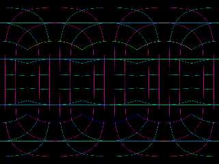
reworked the code a bit, and that didn't help any. Then I switched over to f_th
and f_ph instead of whatever I was using to convert from Cartesian to
latitude/longitude.
That fixed things nicely - almost.
A have some straight horizontal lines now that create "extra" latitudinal
lines/circles. So I'll have to puzzle out the origin of those. net> wrote:
> So, I'm trying to take the face subdivisions from a QuadSphere and uv-unwrap
> them so I can overlay it on an image map.
>
> I tried generating cartesian corner vertices, converting to spherical
> coordinates, and then just plotting those theta and phi angles on the x and y
> with faux-sphere-sweeps for the horizontal and vertical coordinates, and got
> some odd results.
reworked the code a bit, and that didn't help any. Then I switched over to f_th
and f_ph instead of whatever I was using to convert from Cartesian to
latitude/longitude.
That fixed things nicely - almost.
A have some straight horizontal lines now that create "extra" latitudinal
lines/circles. So I'll have to puzzle out the origin of those.
Post a reply to this message
Attachments:
Download 'cubesphere_uvgridmaker.png' (186 KB)
Preview of image 'cubesphere_uvgridmaker.png'
|


