|
|
|
|
|
|
| |
| |
|
|
|
|
| |
| |
|
|
> It should. The attached render uses a converted and eroded digital elevation
> model of Morongo Valley, CA (elevation lines were arbitrarily chosen).
This is an interesting render.
Paolo
Post a reply to this message
|
|
| |
| |
|
|
|
|
| |
| |
|
|
So, with the gracious assistance of Mr. Benge, I have been able to
progress by leaps and bounds, adding the initial pass of roads
(transcribed from the mod that adds those to the world map). I have
made some minor adjustments to make the roads better fit the terrain,
but not many; somewhat surprisingly (to me, at least), the roads in
Skyrim follow the contours of the land in a way that makes sense. Usually.
I had rendered the contour lines a bit light, I need to either rerender
or adjust in another layer. The landmark icons are the in-game ones,
and I need to verify/correct their locations, and replace them with
appropriate 'real' map symbols (or things that look as such). Think I
need to check on some of the roads, too, but...it's a great deal further
along than I had hoped to be.
When this is complete, the next logical stage will be to render the rest
of the terrain data and make a mod for Skyrim to display the topography
in its world map.
--
Tim Cook
http://empyrean.sjcook.com
Post a reply to this message
Attachments:
Download '2456219 skyrim topo.jpg' (946 KB)
Preview of image '2456219 skyrim topo.jpg'
|
|
| |
| |
|
|
|
|
| |
| |
|
|
Awesome.
Thomas
Post a reply to this message
|
|
| |
| |
|
|
|
|
| |
| |
|
|
>Tim Cook on date 18/10/2012 19.28 wrote:
> So, with the gracious assistance of Mr. Benge, I have been able to
> progress by leaps and bounds, adding the initial pass of roads
> (transcribed from the mod that adds those to the world map). I have
> made some minor adjustments to make the roads better fit the terrain,
> but not many; somewhat surprisingly (to me, at least), the roads in
> Skyrim follow the contours of the land in a way that makes sense. Usually.
>
> I had rendered the contour lines a bit light, I need to either rerender
> or adjust in another layer. The landmark icons are the in-game ones,
> and I need to verify/correct their locations, and replace them with
> appropriate 'real' map symbols (or things that look as such). Think I
> need to check on some of the roads, too, but...it's a great deal further
> along than I had hoped to be.
>
> When this is complete, the next logical stage will be to render the rest
> of the terrain data and make a mod for Skyrim to display the topography
> in its world map.
>
> --
> Tim Cook
> http://empyrean.sjcook.com
This is an intriguing map!
Paolo
Post a reply to this message
|
|
| |
| |
|
|
|
|
| |
| |
|
|
Paolo Gibellini <p.g### [at] gmail com> wrote:
> > It should. The attached render uses a converted and eroded digital elevation
> > model of Morongo Valley, CA (elevation lines were arbitrarily chosen).
> This is an interesting render.
> Paolo
That about describes it, because it's certainly not accurate. Besides
arbitrarily placing the contours, I'd managed to accidently get the map both
flipped horizontally and rotated 180 degrees. You'd think after all these years,
I'd know better! :P com> wrote:
> > It should. The attached render uses a converted and eroded digital elevation
> > model of Morongo Valley, CA (elevation lines were arbitrarily chosen).
> This is an interesting render.
> Paolo
That about describes it, because it's certainly not accurate. Besides
arbitrarily placing the contours, I'd managed to accidently get the map both
flipped horizontally and rotated 180 degrees. You'd think after all these years,
I'd know better! :P
Post a reply to this message
|
|
| |
| |
|
|
|
|
| |
| |
|
|
Tim Cook <z99### [at] gmailcom> wrote:
> So, with the gracious assistance of Mr. Benge, I have been able to
> progress by leaps and bounds, adding the initial pass of roads
> (transcribed from the mod that adds those to the world map). I have
> made some minor adjustments to make the roads better fit the terrain,
> but not many; somewhat surprisingly (to me, at least), the roads in
> Skyrim follow the contours of the land in a way that makes sense. Usually.
>
> I had rendered the contour lines a bit light, I need to either rerender
> or adjust in another layer. The landmark icons are the in-game ones,
> and I need to verify/correct their locations, and replace them with
> appropriate 'real' map symbols (or things that look as such). Think I
> need to check on some of the roads, too, but...it's a great deal further
> along than I had hoped to be.
>
> When this is complete, the next logical stage will be to render the rest
> of the terrain data and make a mod for Skyrim to display the topography
> in its world map.
It's looking good, Tim. Seems like it would be a fun place to explore. Are the
elevation lines in sync with Skyrim's sense of altitude?
Post a reply to this message
|
|
| |
| |
|
|
|
|
| |
| |
|
|
On 2012-10-19 15:34, Samuel Benge wrote:
> It's looking good, Tim. Seems like it would be a fun place to explore. Are the
> elevation lines in sync with Skyrim's sense of altitude?
The in-game scale is 128 units = 6 feet, and the Throat of the World
being at 21600 units above sea level. That comes to 1012.5 feet...a bit
short (Mt. Everest (er, Qomolongma) is 4.7 miles).
HOWEVER, if you look at the scale of things /along the ground/, the
horizontal distance between Dawnstar and Winterhold is about 61350
units. That'd be 2867 feet (bit over half a mile). Per canon (near as
I can tell, if this other map is accurate), it should be about 75 miles.
So horizontally it's off by let's say a factor of 40 (I'd previously
calculated it to 10, so need to fix my scale), and if you scale up the
verticals by the same amount, that puts the Throat of the World at 7.67
miles. So...let's say vertical exaggeration of 25x, puts the highest
peak on Nirn at 4.79 miles, and the lowest depth (on the map I have) at
25290 units below sea level, or 5.61 miles adjusting for the 25x factor
(Challenger Deep on Earth is 6.85 miles).
So I need to rerender after figuring... Total altitude range is 46890
units, which ends up being 54949 feet...let's say 55,000 feet. Calling
the macro with 11 would give 5000-foot indexes. (Had used 13 and change
on my current version).
--
Tim Cook
http://empyrean.sjcook.com
Post a reply to this message
|
|
| |
| |
|
|
|
|
| |
| |
|
|
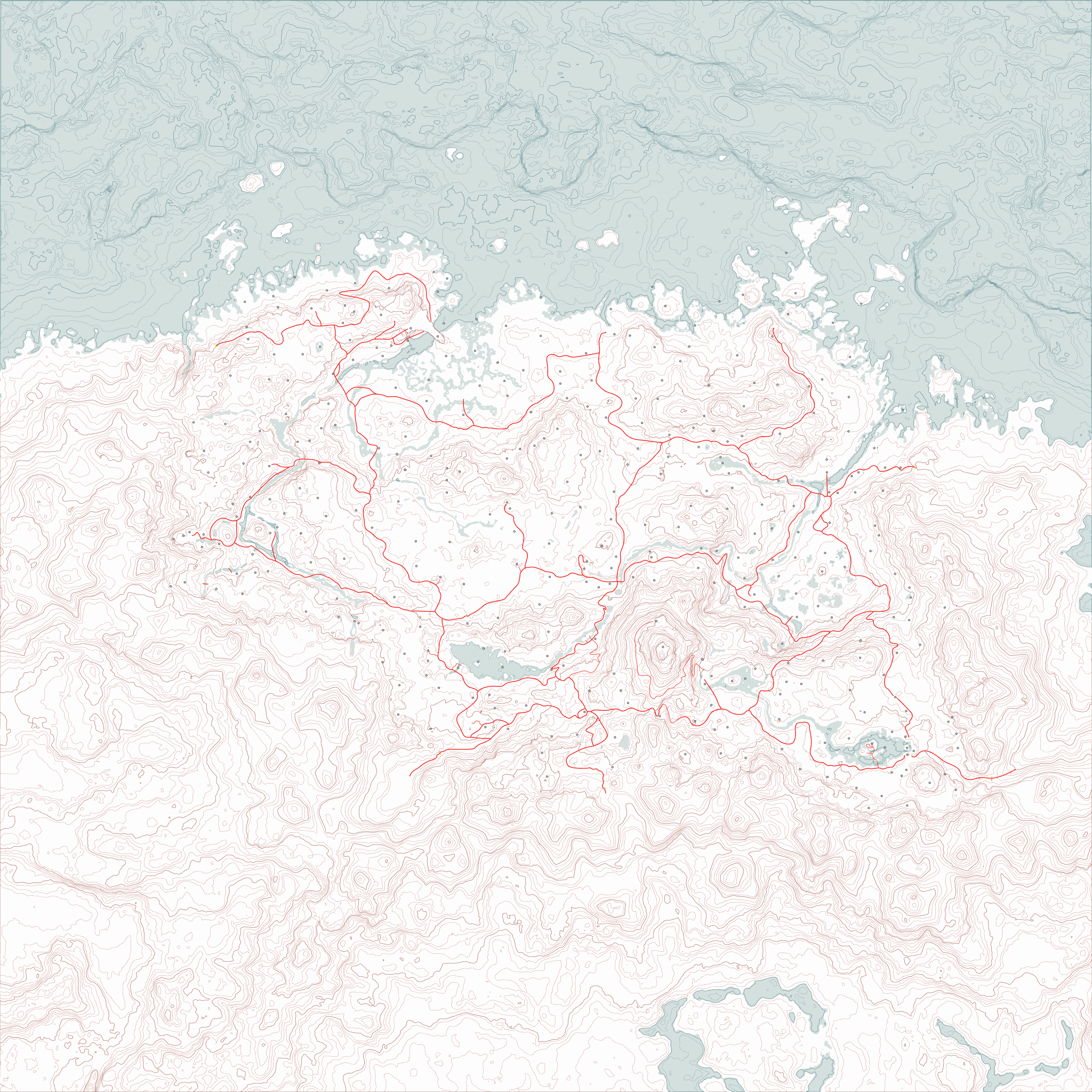
And here's a sized-down version of the current version of the map.
Turns out an 8192x8192 image isn't something my computer is particularly
happy about being asked to work with, with multiple layers (even vector)
in an image editor.
I yet need to go in and do the shoreline and water features, swap out
the placeholder dots with map symbols, add the secondary and tertiary
roads, the borders, expand into Cyrodiil, High Rock, Hammerfell, and
Morrowind, add the canon cities from Skyrim that were left out of Skyrim
the game, maybe mark the forested areas...oh yeah and add labels to
everything.
--
Tim Cook
http://empyrean.sjcook.com
Post a reply to this message
Attachments:
Download 'tamriel topo 2048.png' (762 KB)
Preview of image 'tamriel topo 2048.png'
|
|
| |
| |
|
|
|
|
| |
| |
|
|
Tim Cook <z99### [at] gmailcom> wrote:
> And here's a sized-down version of the current version of the map.
> Turns out an 8192x8192 image isn't something my computer is particularly
> happy about being asked to work with, with multiple layers (even vector)
> in an image editor.
Looks good. Red lines are paved roads, yes?
Is it worth trying to convert this to a vector format, svg or something? This
type of graphic cries out to be in a non-bitmap form.
Bill
Post a reply to this message
|
|
| |
| |
|
|
|
|
| |
| |
|
|
On 2012-10-25 02:26, Bill Pragnell wrote:
> Looks good. Red lines are paved roads, yes?
Thicker ones, yes. Started adding a few secondary unpaved roads; 7000
Steps up to High Hrothgar in particular was missing in the map mod I
had, so I had to compile and use the UESP wiki's map (which is much
better reference).
> Is it worth trying to convert this to a vector format, svg or something? This
> type of graphic cries out to be in a non-bitmap form.
Ah yeah, svg might be a better format to use than psp. I don't want to
hand-trace and optimize all the contour lines, though. :( The
coastline and waterways stage is going to be enough of a nuisance. Any
program that can do that for me?
It would massively reduce the file size.
Also note: the image should be able to be chopped up and converted into
.dds files and used as the in-game map, at this point. There's a bit of
distortion due to my initial rendering of the height map from Moray,
which doesn't have the orthographic camera type, but it should be minor.
--
Tim Cook
http://empyrean.sjcook.com
Post a reply to this message
|
|
| |
| |
|
|
|
|
| |
|
|