|
|
|
|
|
|
| |
| |
|
|
|
|
| |
| |
|
|
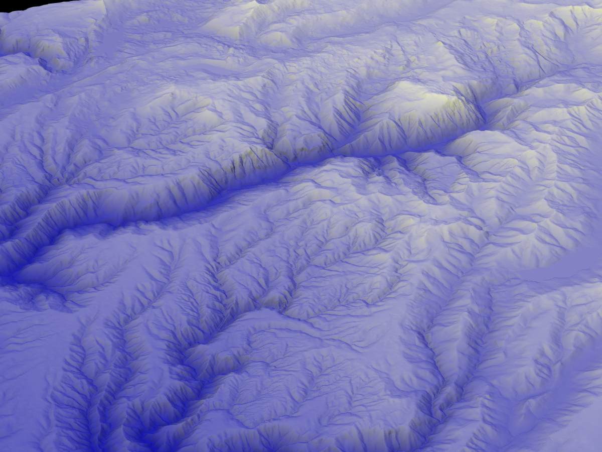
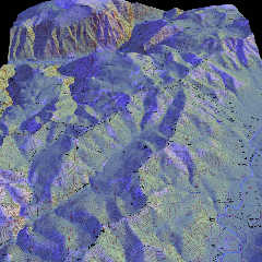
Using a little but powerful program called MacDEM, I merged nine USGS
7.5-minute DEM quadrangles to span an area some fifteen or twenty miles
square. These merged DEMS were written to a 24-bit Targa file along with an
accompanying scene file with the correct scaling for the height field.
This is in California's Sierra Nevada, west of Lake Tahoe. The most
prominent canyon is that of the North Fork American River. It is over three
thousand feet deep. The view is from the south looking north. Various
canyons in the Middle Fork American are also in view, as is the South Yuba,
and the upper Bear River. I-80 traverses this part of the Sierra--but it
stays well away from the North Fork canyon. Fortunately.
There is no vertical exagerration. A color map was applied giving dark blue
to the least elevations, and white to the highest--there is a range of
about six thousand feet in the landscape.
A blue light sines form straight above, and a yellow light from the
southwest.
I use these landscape renderings to help understand local geology and
geomorphology. One can often see changes in bedrock, or the difference
between glacial, or purely fluvial, erosion regimes. This contrast is
visible in the accompanying image: to the east north (right and up), the
terrain was severely glaciated; to the west and south, the ice never
reached, but the meltwater from the glaciers and ice caps rapidly deepened
and oversteepened the canyons.
Post a reply to this message
Attachments:
Download 'northforkeast.jpg' (100 KB)
Preview of image 'northforkeast.jpg'
|
|
| |
| |
|
|
|
|
| |
| |
|
|
High!
Welcome aboard!
Russell Towle wrote:
> Using a little but powerful program called MacDEM, I merged nine USGS
> 7.5-minute DEM quadrangles to span an area some fifteen or twenty miles
> square. These merged DEMS were written to a 24-bit Targa file along with an
> accompanying scene file with the correct scaling for the height field.
Impressive... another 3D cartography/terrain visualization geek on the
server! As I myself since some time try to build semi-realistic (at
least for now) Afghan landscapes from SRTM tiles, I really would like to
know whether this or similar programs are available also for Windows
98 or Linux - until now, I only managed to use single 3-arc SRTM tiles
with 1200 by 1200 data points, as my software, 3DEM, doesn't support
merging of tiles.
I speak of "data points" rather than "pixels", as I don't use the tiles
for heightfields, but for meshes which follow Earth's curvature. A
(still crude, as up to now I didn't yet find a way to do *real* mesh
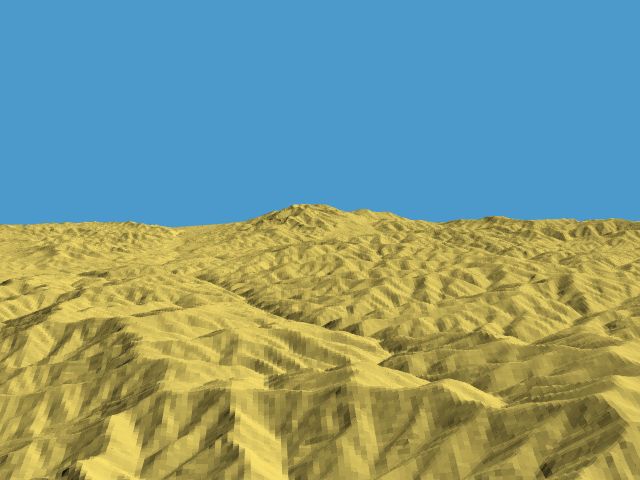
smoothing) preliminary result of this efforts is attached here. It shows
between the famous Bamiyan valley and Kabul.
Parallel to this, I work on a more detailed heightfield of the Kabul
area from a Russian-made 1:100,000 topographic map - as such maps of
course use a kind of equal-area projection rather than simple
cylindrical like with the SRTMs, I yet have to find out a way to
transform their geodesic coordinates into geographic coordinates to make
curved meshes out of them.
Doing this manually is a painstakingly slow work - for a first "test", I
content myself with the north-eastern quadrangle of the map (containing
the stunning Tang-e Gharu gorge), and even this means about 2 million
pixels to be placed! As I on average place 3,000 pixels per hour, you
can guess how long it will like... meanwhile, I'm about halfway through,
and I started in October 2004! By the way, this would not be my first
landscape pixeled from a topographic map - in 1998/99. I did such a work
depicting a less exciting part of the world (to be exact, the uplands
east of Cologne, Germany, but with a terrain texture reminding more of
Afghanistan...)...
I know that there a Windows program named "BlackArt" exists which is
able to interpolate the missing heightfield pixels between existing
contour lines, but didn't find the time yet to occupy myself thoroughly
with this software, as I would like to see the results of both methods
in comparison, finishing the manually pixeled heightfield has a higher
priority now.
See you in Khyberspace -
http://home.arcor.de/yadgar/khyberspace/index-e.html
Afghanistan Chronicle: http://home.arcor.de/yadgar/
Yadgar
Now playing: Heat of the Moment (Asia)
Post a reply to this message
Attachments:
Download '2005-04-02 sar-e helmand, take 1 (yadgar).jpg' (43 KB)
Preview of image '2005-04-02 sar-e helmand, take 1 (yadgar).jpg'
|
|
| |
| |
|
|
|
|
| |
| |
|
|
> Impressive... another 3D cartography/terrain visualization geek on the
> server! As I myself since some time try to build semi-realistic (at
> least for now) Afghan landscapes from SRTM tiles, I really would like to
> know whether this or similar programs are available also for Windows
> 98 or Linux - until now, I only managed to use single 3-arc SRTM tiles
> with 1200 by 1200 data points, as my software, 3DEM, doesn't support
> merging of tiles.
Hey, very interesting, the Afghan landscape is surely among the most
dramatic on earth.
I know nothing about Windows.
But for the Mac go to http://www.treeswallow.com/macdem/ and download the
trial version. It is an amazingly small piece of software for all that it
does. It automatically fills in data voids, such as are common enough on
our DEM files, and tiles multiple DEMS or other data formats such as SDTS.
I see nothing to make a mesh better than a heightfield; quite the opposite,
the height field is a much more economical way to represent the terain.
Sixteen bits, or two bytes, is more than enough to achive meter-level
resolution here on earth.
It is frustrating to be stuck in this nascent stage of mapping, when our
data set is so limited. Right now, I think 7.5 minute DEMs, with 30 meters
of horizontal resolution, and 1-meter vertical resolution, wonderful.
But I'd much rather have 1-meter-horizontal DEMs with elevations to the
nearest centimeter. The shape of the earth is a wondrous thing. These
higher-resolution data sets are on the way.
I started rendering the DEM data set to virtual landscpaes in 1995, using
Mathematica. I figured out how to use Mathematica to read DEMs and export
height fields for POV, and scene files. I then ported a little POV
DEM-to-height-field utility to the Mac way back when. It was a bad hack as
I recall. MacDEM changed everything. When I saw it read in a 1 MB DEM and
create a shaded landscape in about two seconds, I emailed the author and
begged him to add POV support, which he gladly and ably did at once. So
MacDEM not only stitches, fills in voids, handles multiple formats, but
exports to POV.
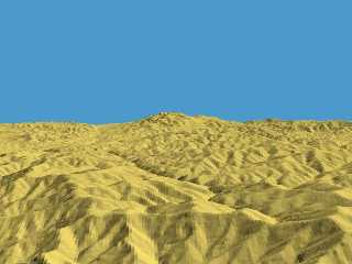
It is also possible to use a topographic map scan as an image_map to color
the height field, as per attached.
Post a reply to this message
Attachments:
Download 'royal_gorge_sun.jpg' (273 KB)
Preview of image 'royal_gorge_sun.jpg'
|
|
| |
| |
|
|
|
|
| |
| |
|
|
Russell Towle wrote:
>
> It is frustrating to be stuck in this nascent stage of mapping, when our
> data set is so limited. Right now, I think 7.5 minute DEMs, with 30 meters
> of horizontal resolution, and 1-meter vertical resolution, wonderful.
>
> But I'd much rather have 1-meter-horizontal DEMs with elevations to the
> nearest centimeter. The shape of the earth is a wondrous thing. These
> higher-resolution data sets are on the way.
Actually there are 1/3 arc second DEMs available for most parts of the
US. But you won't get reasonable results if you convert them to 1 meter
vertical resolution.
And for outside North America (especially Europe where high resolution
data exists, just kept under lock by the mapping agencies) things look
very bad.
Christoph
--
POV-Ray tutorials, include files, Landscape of the week:
http://www.imagico.de/ (Last updated 14 Mar. 2006)
MegaPOV with mechanics simulation: http://megapov.inetart.net/
Post a reply to this message
|
|
| |
| |
|
|
|
|
| |
| |
|
|
Russell Towle wrote:
> I use these landscape renderings to help understand local geology and
> geomorphology. One can often see changes in bedrock, or the difference
> between glacial, or purely fluvial, erosion regimes. This contrast is
> visible in the accompanying image: to the east north (right and up), the
> terrain was severely glaciated; to the west and south, the ice never
> reached, but the meltwater from the glaciers and ice caps rapidly deepened
> and oversteepened the canyons.
Earth forensics? The crimes of glaciers.
Post a reply to this message
|
|
| |
| |
|
|
|
|
| |
|
|