|
 |
> Impressive... another 3D cartography/terrain visualization geek on the
> server! As I myself since some time try to build semi-realistic (at
> least for now) Afghan landscapes from SRTM tiles, I really would like to
> know whether this or similar programs are available also for Windows
> 98 or Linux - until now, I only managed to use single 3-arc SRTM tiles
> with 1200 by 1200 data points, as my software, 3DEM, doesn't support
> merging of tiles.
Hey, very interesting, the Afghan landscape is surely among the most
dramatic on earth.
I know nothing about Windows.
But for the Mac go to http://www.treeswallow.com/macdem/ and download the
trial version. It is an amazingly small piece of software for all that it
does. It automatically fills in data voids, such as are common enough on
our DEM files, and tiles multiple DEMS or other data formats such as SDTS.
I see nothing to make a mesh better than a heightfield; quite the opposite,
the height field is a much more economical way to represent the terain.
Sixteen bits, or two bytes, is more than enough to achive meter-level
resolution here on earth.
It is frustrating to be stuck in this nascent stage of mapping, when our
data set is so limited. Right now, I think 7.5 minute DEMs, with 30 meters
of horizontal resolution, and 1-meter vertical resolution, wonderful.
But I'd much rather have 1-meter-horizontal DEMs with elevations to the
nearest centimeter. The shape of the earth is a wondrous thing. These
higher-resolution data sets are on the way.
I started rendering the DEM data set to virtual landscpaes in 1995, using
Mathematica. I figured out how to use Mathematica to read DEMs and export
height fields for POV, and scene files. I then ported a little POV
DEM-to-height-field utility to the Mac way back when. It was a bad hack as
I recall. MacDEM changed everything. When I saw it read in a 1 MB DEM and
create a shaded landscape in about two seconds, I emailed the author and
begged him to add POV support, which he gladly and ably did at once. So
MacDEM not only stitches, fills in voids, handles multiple formats, but
exports to POV.
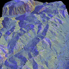
It is also possible to use a topographic map scan as an image_map to color
the height field, as per attached.
Post a reply to this message
Attachments:
Download 'royal_gorge_sun.jpg' (273 KB)
Preview of image 'royal_gorge_sun.jpg'
|
|


