|
 |
High!
Welcome aboard!
Russell Towle wrote:
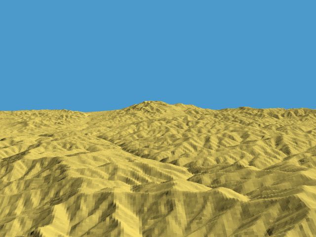
> Using a little but powerful program called MacDEM, I merged nine USGS
> 7.5-minute DEM quadrangles to span an area some fifteen or twenty miles
> square. These merged DEMS were written to a 24-bit Targa file along with an
> accompanying scene file with the correct scaling for the height field.
Impressive... another 3D cartography/terrain visualization geek on the
server! As I myself since some time try to build semi-realistic (at
least for now) Afghan landscapes from SRTM tiles, I really would like to
know whether this or similar programs are available also for Windows
98 or Linux - until now, I only managed to use single 3-arc SRTM tiles
with 1200 by 1200 data points, as my software, 3DEM, doesn't support
merging of tiles.
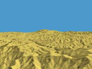
I speak of "data points" rather than "pixels", as I don't use the tiles
for heightfields, but for meshes which follow Earth's curvature. A
(still crude, as up to now I didn't yet find a way to do *real* mesh
smoothing) preliminary result of this efforts is attached here. It shows
between the famous Bamiyan valley and Kabul.
Parallel to this, I work on a more detailed heightfield of the Kabul
area from a Russian-made 1:100,000 topographic map - as such maps of
course use a kind of equal-area projection rather than simple
cylindrical like with the SRTMs, I yet have to find out a way to
transform their geodesic coordinates into geographic coordinates to make
curved meshes out of them.
Doing this manually is a painstakingly slow work - for a first "test", I
content myself with the north-eastern quadrangle of the map (containing
the stunning Tang-e Gharu gorge), and even this means about 2 million
pixels to be placed! As I on average place 3,000 pixels per hour, you
can guess how long it will like... meanwhile, I'm about halfway through,
and I started in October 2004! By the way, this would not be my first
landscape pixeled from a topographic map - in 1998/99. I did such a work
depicting a less exciting part of the world (to be exact, the uplands
east of Cologne, Germany, but with a terrain texture reminding more of
Afghanistan...)...
I know that there a Windows program named "BlackArt" exists which is
able to interpolate the missing heightfield pixels between existing
contour lines, but didn't find the time yet to occupy myself thoroughly
with this software, as I would like to see the results of both methods
in comparison, finishing the manually pixeled heightfield has a higher
priority now.
See you in Khyberspace -
http://home.arcor.de/yadgar/khyberspace/index-e.html
Afghanistan Chronicle: http://home.arcor.de/yadgar/
Yadgar
Now playing: Heat of the Moment (Asia)
Post a reply to this message
Attachments:
Download '2005-04-02 sar-e helmand, take 1 (yadgar).jpg' (43 KB)
Preview of image '2005-04-02 sar-e helmand, take 1 (yadgar).jpg'
|
|