|
|
|
|
|
|
| |
| |
|
|
|
|
| |
| |
|
|
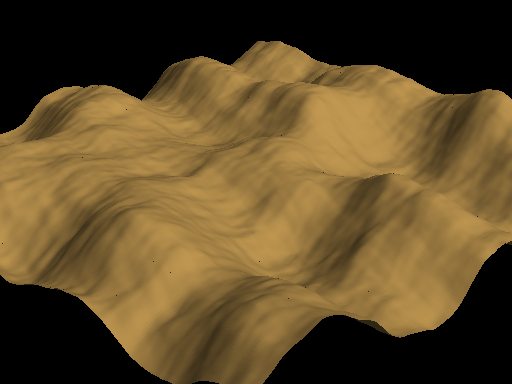
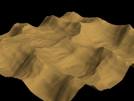
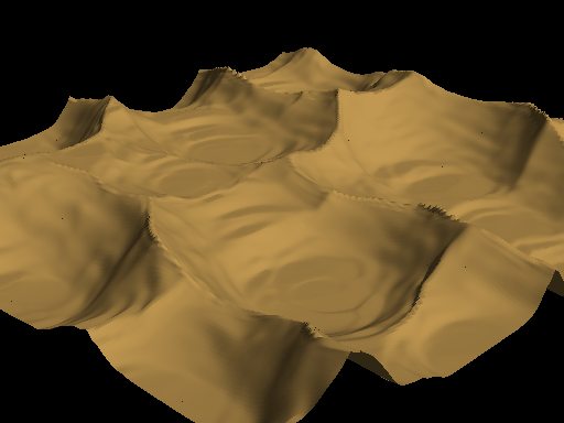
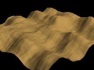
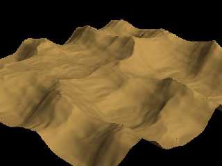
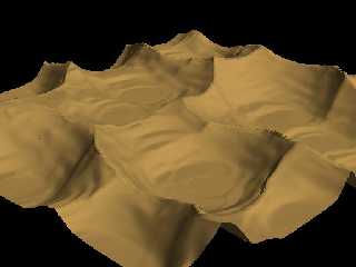
Just made some tests with an Erosion routine I programmed some time ago. The
result has some similarity with ridged multifractal but it is an editing
function modifying any existing heightfield.
And it is quite fast (about 800 milliseconds for a single run on a 256x256
point heightfield on my K6/500)
The first one is the starting heightfield, the second one after about 15 runs
with smoothing between, the third after 15 additional runs.
Please tell me what you think of it, I wonder if anybody has done something
similar before.
I am already planning some addition to stop erosion process, when a certain
slope is reached, which would be more realistic.
Christoph
--
Christoph Hormann <chr### [at] gmx de>
Homepage: http://www.schunter.etc.tu-bs.de/~chris/ de>
Homepage: http://www.schunter.etc.tu-bs.de/~chris/
Post a reply to this message
Attachments:
Download 'erode1.jpg' (21 KB)
Download 'erode2.jpg' (20 KB)
Download 'erode3.jpg' (20 KB)
Preview of image 'erode1.jpg'
Preview of image 'erode2.jpg'
Preview of image 'erode3.jpg'
|
|
| |
| |
|
|
|
|
| |
| |
|
|
Hmm, they look more like they're in reverse order. Tall, pointy peaks should get
rounded off.
--
David Fontaine <dav### [at] faricynet> ICQ 55354965
Please visit my website: http://www.faricy.net/~davidf/
Post a reply to this message
|
|
| |
| |
|
|
|
|
| |
| |
|
|
David Fontaine wrote:
>
> Hmm, they look more like they're in reverse order. Tall, pointy peaks should get
> rounded off.
>
no, they are in right order :-)
Have you ever looked at a mountain region from above: most mountains have quite
plane sides and very sharp ridges.
Christoph
--
Christoph Hormann <chr### [at] gmxde>
Homepage: http://www.schunter.etc.tu-bs.de/~chris/
Post a reply to this message
|
|
| |
| |
|
|
|
|
| |
| |
|
|
In article <396A1D01.C701A4CD@schunter.etc.tu-bs.de>,
chr### [at] gmxde wrote:
> Have you ever looked at a mountain region from above: most mountains
> have quite plane sides and very sharp ridges.
Yes, but they eventually get smoothed over by time and weather. Sharp
points and steep sides shear off and the debris accumulates at the
bottom, and the mountain becomes more hill-like and rounded.
Your filter looks more like a "time machine", reversing the normal
erosion process.
--
Christopher James Huff - Personal e-mail: chr### [at] maccom
TAG(Technical Assistance Group) e-mail: chr### [at] tagpovrayorg
Personal Web page: http://homepage.mac.com/chrishuff/
TAG Web page: http://tag.povray.org/
Post a reply to this message
|
|
| |
| |
|
|
|
|
| |
| |
|
|
i think it depends on whether it is wind erosion or water erosion. wind
rounds, water peaks.
if you could define areas most and least likely to erode, that would be
cool. for example, areas with a lot of ground cover don't erode as fast
as open areas. dirt erodes faster than rock, etc.
Post a reply to this message
|
|
| |
| |
|
|
|
|
| |
| |
|
|
Chris Huff wrote:
>
[...]
>
> Yes, but they eventually get smoothed over by time and weather. Sharp
> points and steep sides shear off and the debris accumulates at the
> bottom, and the mountain becomes more hill-like and rounded.
> Your filter looks more like a "time machine", reversing the normal
> erosion process.
>
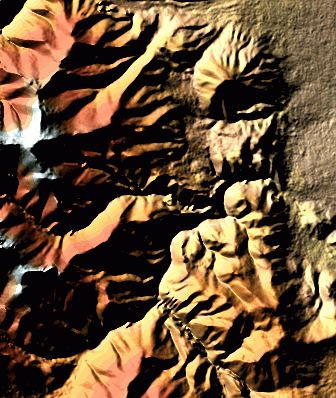
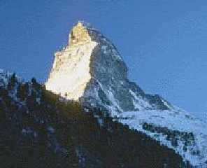
It depends on the material, of course hillsides do not get infinitely steep, but
it can be quite extreme like in the attached photo.
Christoph
--
Christoph Hormann <chr### [at] gmxde>
Homepage: http://www.schunter.etc.tu-bs.de/~chris/
Post a reply to this message
Attachments:
Download 'mount1.jpg' (8 KB)
Preview of image 'mount1.jpg'
|
|
| |
| |
|
|
|
|
| |
| |
|
|
"Christoph Hormann" <Chr### [at] schunteretctu-bsde> wrote :
>
> Have you ever looked at a mountain region from above: most mountains have
quite
> plane sides and very sharp ridges.
Some mountains look sharp because they have been recently pushed up.
Even old mountains look that way if they are still being pushed up. But old
mountains in areas with no recent plate activity are rounded by erosion.
Your photo is clearly one of an upthrust formation of some sort. In a
billion years it will be a rounded boulder.
--
I get paid to do -anything- while connected to the internet.
Please use my referral id to find out more
http://www.getpaid4.com/?billdewitt
Post a reply to this message
|
|
| |
| |
|
|
|
|
| |
| |
|
|
ryan constantine wrote:
>
> i think it depends on whether it is wind erosion or water erosion. wind
> rounds, water peaks.
>
IMO this type of erosion is mainly caused by the changing temperatures
destroying the structure of the material at the surface. Of course water and
wind are major factors for transportation of material.
> if you could define areas most and least likely to erode, that would be
> cool. for example, areas with a lot of ground cover don't erode as fast
> as open areas. dirt erodes faster than rock, etc.
That's a good idea, it is only a problem how to define those areas.
BTW, my code partly already does this, because it erodes more on steeper areas,
where there is normally fewer vegetation.
Christoph
--
Christoph Hormann <chr### [at] gmxde>
Homepage: http://www.schunter.etc.tu-bs.de/~chris/
Post a reply to this message
|
|
| |
| |
|
|
|
|
| |
| |
|
|
Can a routine be made to do wind erosion? Desert landscapes could be made with
these mushroom shaped rocks that get eroded more at the bottom. However, I'm not
sure if that can be done with height fields.
Brendan
Christoph Hormann wrote:
> Just made some tests with an Erosion routine I programmed some time ago. The
> result has some similarity with ridged multifractal but it is an editing
> function modifying any existing heightfield.
>
> And it is quite fast (about 800 milliseconds for a single run on a 256x256
> point heightfield on my K6/500)
>
> The first one is the starting heightfield, the second one after about 15 runs
> with smoothing between, the third after 15 additional runs.
>
> Please tell me what you think of it, I wonder if anybody has done something
> similar before.
>
> I am already planning some addition to stop erosion process, when a certain
> slope is reached, which would be more realistic.
>
> Christoph
>
> --
> Christoph Hormann <chr### [at] gmxde>
> Homepage: http://www.schunter.etc.tu-bs.de/~chris/
>
> ------------------------------------------------------------------------
> [Image] [Image] [Image]
Post a reply to this message
|
|
| |
| |
|
|
|
|
| |
| |
|
|
Bill DeWitt wrote:
>
[...]
>
> Some mountains look sharp because they have been recently pushed up.
> Even old mountains look that way if they are still being pushed up. But old
> mountains in areas with no recent plate activity are rounded by erosion.
> Your photo is clearly one of an upthrust formation of some sort. In a
> billion years it will be a rounded boulder.
>
Agreed, but on the other hand, the sharp structures often correspond with the
river network, which suggests, that they are also partly formed by erosion.
The photo is not a very good example, very good are usually satellite pictures
where you can see the sharp edges in the light *and* the rivers.
just found one (sorry for the many pictures), well in fact it's a radar image,
but it should work...
Christoph
--
Christoph Hormann <chr### [at] gmxde>
Homepage: http://www.schunter.etc.tu-bs.de/~chris/
Post a reply to this message
Attachments:
Download 'mount2.jpg' (44 KB)
Preview of image 'mount2.jpg'

|
|
| |
| |
|
|
|
|
| |