|
|
|
|
|
|
| |
| |
|
|
From: William F Pokorny
Subject: Using AOI & orthographic camera to bring out detail in DEM based isosurface.
Date: 19 Aug 2013 12:44:42
Message: <52124b7a@news.povray.org>
|
|
|
| |
| |
|
|
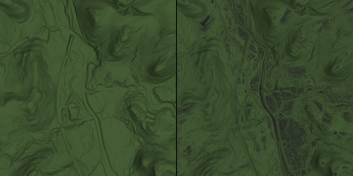
I've been playing around with public LIDAR derived digital elevation
maps. On the left a plain DEM isosurface with a green color. On the
right, an image using the AOI pattern of 3.7 to highlight relatively
flat areas. The method works well. A thank you to the development team
for adding the AOI pattern to 3.7.
Bill P.
Post a reply to this message
Attachments:
Download 'story.jpg' (136 KB)
Preview of image 'story.jpg'
|
|
| |
| |
|
|
|
|
| |
| |
|
|
William F Pokorny <ano### [at] anonymous org> wrote:
> I've been playing around with public LIDAR derived digital elevation
> maps. On the left a plain DEM isosurface with a green color. On the
> right, an image using the AOI pattern of 3.7 to highlight relatively
> flat areas. The method works well.
Good application, William. Elevation data + POV-Ray = good times.
Have you tried using a proximity pattern for that yet?
Sam org> wrote:
> I've been playing around with public LIDAR derived digital elevation
> maps. On the left a plain DEM isosurface with a green color. On the
> right, an image using the AOI pattern of 3.7 to highlight relatively
> flat areas. The method works well.
Good application, William. Elevation data + POV-Ray = good times.
Have you tried using a proximity pattern for that yet?
Sam
Post a reply to this message
|
|
| |
| |
|
|
From: William F Pokorny
Subject: Re: Using AOI & orthographic camera to bring out detail in DEM based isosur=
Date: 21 Aug 2013 07:30:22
Message: <5214a4ce$1@news.povray.org>
|
|
|
| |
| |
|
|
On 08/19/2013 03:19 PM, Samuel Benge wrote:
>
> Good application, William. Elevation data + POV-Ray = good times.
>
> Have you tried using a proximity pattern for that yet?
>
> Sam
>
Hi Sam,
Yep, it's fun.
No, I have not tried a proximity pattern. That's a great idea for
pulling out ditches, gullies and such. Thanks!
I expect GIS professionals have custom tools for interpreting elevation
data, but, finding quite a lot can be done within POV-Ray itself.
Bill P.
Post a reply to this message
|
|
| |
| |
|
|
From: Jörg 'Yadgar' Bleimann
Subject: Re: Using AOI & orthographic camera to bring out detail in DEM basedisosurface.
Date: 17 Sep 2013 10:37:38
Message: <52386932$1@news.povray.org>
|
|
|
| |
| |
|
|
Hi(gh)!
On 19.08.2013 18:44, William F Pokorny wrote:
> I've been playing around with public LIDAR derived digital elevation
> maps. On the left a plain DEM isosurface with a green color. On the
> right, an image using the AOI pattern of 3.7 to highlight relatively
> flat areas. The method works well. A thank you to the development team
> for adding the AOI pattern to 3.7.
>
> Bill P.
An isosurface from a DEM?!? Does it follow Earth's curvature or is it
simply a flat "heightfield"? Could you render any surface vistas in
"pedestrian view"?
See you in Khyberspace!
Yadgar
Now playing: First Rendez-Vous (Jean-Michel Jarre)
Post a reply to this message
|
|
| |
| |
|
|
From: William F Pokorny
Subject: Re: Using AOI & orthographic camera to bring out detail in DEM basedisosurface.
Date: 20 Sep 2013 19:59:16
Message: <523ce154@news.povray.org>
|
|
|
| |
| |
|
|
> Hi(gh)!
>
> An isosurface from a DEM?!? Does it follow Earth's curvature or is it
> simply a flat "heightfield"? Could you render any surface vistas in
> "pedestrian view"?
>
> See you in Khyberspace!
>
> Yadgar
>
Hi Yadgar,
No, the images do not follow the Earth's curvature. The elevation data
as provided by the state government here is set up as "flat" tiles which
can be stitched together.
I haven't tried pedestrian views having gotten distracted by other
things, but it is on my list to do. I have the idea to do it in
combination with the SkySim macro for the sun & sky on some give day at
my position just to see if things match up!
Bill P.
Post a reply to this message
|
|
| |
| |
|
|
|
|
| |