|
|
|
|
|
|
| |
| |
|
|
|
|
| |
| |
|
|
"dlm" <me### [at] address invalid> wrote:
> NASA gives this stuff out
> MOLA data is from laser altimetry experiments and so should be intrinsically
> shadow free.
> if you really want raw data
> http://ltpwww.gsfc.nasa.gov/tharsis/data.html
> or
> http://www.solarviews.com/raw/mgs/mgstopo3.jpg
> and more at
> http://solarviews.com/cap/index/maps-topographic1.html
>
> DLM
thanks ...
anyone have some experience with getting this data
into a form where it can be used with POVray?
Pointers? Tutorials?
tnx
-ts- invalid> wrote:
> NASA gives this stuff out
> MOLA data is from laser altimetry experiments and so should be intrinsically
> shadow free.
> if you really want raw data
> http://ltpwww.gsfc.nasa.gov/tharsis/data.html
> or
> http://www.solarviews.com/raw/mgs/mgstopo3.jpg
> and more at
> http://solarviews.com/cap/index/maps-topographic1.html
>
> DLM
thanks ...
anyone have some experience with getting this data
into a form where it can be used with POVray?
Pointers? Tutorials?
tnx
-ts-
Post a reply to this message
|
|
| |
| |
|
|
|
|
| |
| |
|
|
Mike Williams wrote:
> That's one of the odd things about Google. It's got all these wonderful
> extra bits but they're often hard to find.
If you haven't seen it, check out www.google.com/technology/pigeonrank.html
It's been there for some time, but it's still funny. ;-)
-=- Larry -=-
Post a reply to this message
|
|
| |
| |
|
|
|
|
| |
| |
|
|
> i see google has these available now:
> http://www.google.com/mars/
>
> the color coded elevation maps may be of interest
> for height field experiments.
> too bad the shadows are included.
I separate the channels in TSL mode and use the tone channel for
elevation map, it's work for altitude between -6km to 4-5 km ..
Post a reply to this message
|
|
| |
| |
|
|
|
|
| |
| |
|
|
"ts" <nomail@nomail> schreef in bericht
news:web.44158ed5c01a69decad1b7d40@news.povray.org...
> i see google has these available now:
> http://www.google.com/mars/
>
> the color coded elevation maps may be of interest
> for height field experiments.
> too bad the shadows are included.
> still ... perhaps of use.
>
> -ts-
>
>
Am I mistaken, or is there only a small part of Mars made available here?
The map tiles itself when zooming out.... Not exactly what I am looking
for.... I suppose Nasa has a more complete set.
Thomas
Post a reply to this message
|
|
| |
| |
|
|
|
|
| |
| |
|
|
"ts" <nomail@nomail> schreef in bericht
news:web.44170333ae65d7f087e26f930@news.povray.org...
> "dlm" <me### [at] addressinvalid> wrote:
> > NASA gives this stuff out
> > MOLA data is from laser altimetry experiments and so should be
intrinsically
> > shadow free.
> > if you really want raw data
> > http://ltpwww.gsfc.nasa.gov/tharsis/data.html
> > or
> > http://www.solarviews.com/raw/mgs/mgstopo3.jpg
> > and more at
> > http://solarviews.com/cap/index/maps-topographic1.html
> >
> > DLM
>
> thanks ...
> anyone have some experience with getting this data
> into a form where it can be used with POVray?
> Pointers? Tutorials?
>
I cannot find it at this moment, but USGS should have something. It was
called "<something>topo" I believe. I should have it.....but where? :-(
I think that Mars data could be read with that.
Thomas
Post a reply to this message
|
|
| |
| |
|
|
|
|
| |
| |
|
|
Oh, and I forgot to mention that Leveller is probably able to read this
data!
Thomas
Post a reply to this message
|
|
| |
| |
|
|
|
|
| |
| |
|
|
Wasn't it Thomas de Groot who wrote:
>
>"ts" <nomail@nomail> schreef in bericht
>news:web.44158ed5c01a69decad1b7d40@news.povray.org...
>> i see google has these available now:
>> http://www.google.com/mars/
>>
>> the color coded elevation maps may be of interest
>> for height field experiments.
>> too bad the shadows are included.
>> still ... perhaps of use.
>>
>> -ts-
>>
>>
>Am I mistaken, or is there only a small part of Mars made available here?
>The map tiles itself when zooming out.... Not exactly what I am looking
>for.... I suppose Nasa has a more complete set.
That's the way the Google Map code works. Try it with the Earth and
you'll get the same effect:
http://maps.google.com/maps?q=90210&ll=34.0,-118.0&spn=180,360
But if you're more familiar with Earth geography than Mars you're more
likely to recognise the part of the Earth that gets tiled.
The code works that way so that you get something sensible if you zoom
in 3 or 4 levels and look at a part of the planet near the International
Date Line (or whatever the Mars equivalent is).
--
Mike Williams
Gentleman of Leisure
Post a reply to this message
|
|
| |
| |
|
|
|
|
| |
| |
|
|
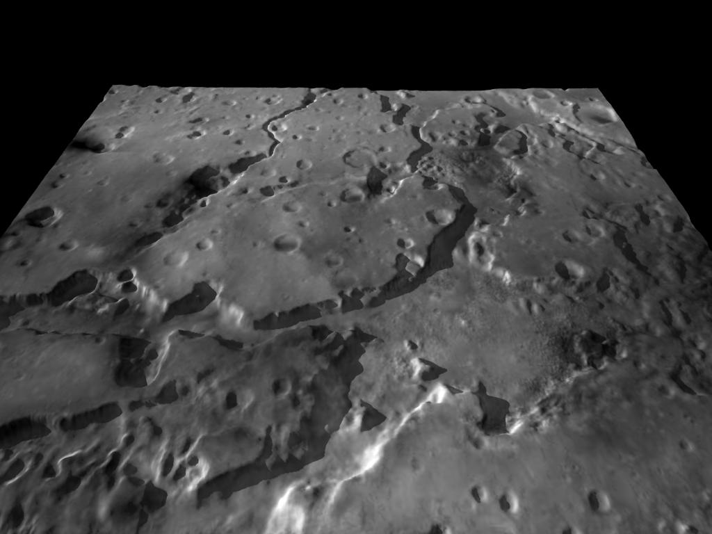
> I separate the channels in TSL mode and use the tone channel for
> elevation map, it's work for altitude between -6km to 4-5 km ..
I want to say HSL and use Hue .. ;)
This is a test with the elevation on a heightfield.
It use the "visible" option in google mars for image-map.
Post a reply to this message
Attachments:
Download 'mars.jpg' (65 KB)
Preview of image 'mars.jpg'

|
|
| |
| |
|
|
|
|
| |
| |
|
|
"zorglub" <zor### [at] e-garfieldcom> schreef in bericht
news:44182606@news.povray.org...
> > I separate the channels in TSL mode and use the tone channel for
> > elevation map, it's work for altitude between -6km to 4-5 km ..
>
> I want to say HSL and use Hue .. ;)
>
> This is a test with the elevation on a heightfield.
> It use the "visible" option in google mars for image-map.
>
>
>
That's really not bad at all!
Thomas
Post a reply to this message
|
|
| |
| |
|
|
|
|
| |
| |
|
|
"dlm" <me### [at] addressinvalid> wrote in message news:441649be@news.povray.org...
> NASA gives this stuff out
> MOLA data is from laser altimetry experiments and so should be
intrinsically
> shadow free.
> if you really want raw data
> http://ltpwww.gsfc.nasa.gov/tharsis/data.html
> or
> http://www.solarviews.com/raw/mgs/mgstopo3.jpg
> and more at
> http://solarviews.com/cap/index/maps-topographic1.html
>
> DLM
>
>
BTW
See Paddy McGee's POV view of Mars with water added etc...
http://www.physics.adelaide.edu.au/~pmcgee/teform2.htm
DLM
Post a reply to this message
|
|
| |
| |
|
|
|
|
| |