|
|
|
|
|
|
| |
| |
|
|
|
|
| |
| |
|
|
Hmm, and it's 21600x21600 chunks, too...how do I make an isosurface that
applies an image as a radius modifier to a section of a sphere so that
the entire image maps to a 45x45-degree segment?
The code I have for the entire image to the whole sphere is
#include "functions.inc"
#declare fn_EarthPigm1=function{
pigment{
image_map{
jpeg "srtm_ramp2.world.5400x2700.jpg"
map_type 1
once
interpolate 4
}
}
}
#declare EarthIso=isosurface{
function{f_sphere(x, y, z, 0.633)-(fn_EarthPigm1(x,y,z).red*0.006)}
contained_by{sphere{0,0.7}}
texture{pigment{rgb 1}}
scale <-1,1,1>
rotate <90,0,-90>
}
...I'm guessing there's a way to apply fn_EarthPigm1 to only part of the
sphere? But how?
--
Tim Cook
http://home.bellsouth.net/p/PWP-empyrean
-----BEGIN GEEK CODE BLOCK-----
Version: 3.12
GFA dpu- s: a?-- C++(++++) U P? L E--- W++(+++)>$
N++ o? K- w(+) O? M-(--) V? PS+(+++) PE(--) Y(--)
PGP-(--) t* 5++>+++++ X+ R* tv+ b++(+++) DI
D++(---) G(++) e*>++ h+ !r--- !y--
------END GEEK CODE BLOCK------
Post a reply to this message
|
|
| |
| |
|
|
|
|
| |
| |
|
|
Tim Cook wrote:
>
> Hmm...well I guess I might be able to do it after all, then...HOLY CRAP
> the 500 m dataset is 65 GB?!
That's wrong. One full data set is exactly 3x86400x43200=11197440000 bytes.
Christoph
--
POV-Ray tutorials, include files, Landscape of the week:
http://www.imagico.de/ (Last updated 31 Oct. 2005)
MegaPOV with mechanics simulation: http://megapov.inetart.net/
Post a reply to this message
|
|
| |
| |
|
|
|
|
| |
| |
|
|
Tim Cook wrote:
> Hmm, and it's 21600x21600 chunks, too...how do I make an isosurface that
> applies an image as a radius modifier to a section of a sphere so that
> the entire image maps to a 45x45-degree segment?
Just map it accordingly - using a mapping warp or manually using the
f_th()/f_ph() functions:
#local fn_Spherical=
function {
fn_Flat(1-(f_th(x,z,y)+pi)/(2*pi), f_ph(x,-z,y)/pi, 0)
}
Christoph
--
POV-Ray tutorials, include files, Landscape of the week:
http://www.imagico.de/ (Last updated 31 Oct. 2005)
MegaPOV with mechanics simulation: http://megapov.inetart.net/
Post a reply to this message
|
|
| |
| |
|
|
|
|
| |
| |
|
|
Christoph Hormann wrote:
> That's wrong. One full data set is exactly 3x86400x43200=11197440000
> bytes.
Yes, but the complete dataset has one set for each month, plus
topography plus bathymetry...
--
Tim Cook
http://home.bellsouth.net/p/PWP-empyrean
-----BEGIN GEEK CODE BLOCK-----
Version: 3.12
GFA dpu- s: a?-- C++(++++) U P? L E--- W++(+++)>$
N++ o? K- w(+) O? M-(--) V? PS+(+++) PE(--) Y(--)
PGP-(--) t* 5++>+++++ X+ R* tv+ b++(+++) DI
D++(---) G(++) e*>++ h+ !r--- !y--
------END GEEK CODE BLOCK------
Post a reply to this message
|
|
| |
| |
|
|
|
|
| |
| |
|
|
Christoph Hormann wrote:
> Just map it accordingly - using a mapping warp or manually using the
> f_th()/f_ph() functions:
Trying out the mapping warp on the texture to get a feel for the method,
but not sure how to make the image occupy a different sector of the
sphere... warp{spherical orientation z dist_exp 1} scale <-0.5,0.5,0.5>
rotate 90*x gives a segment from 90 degrees 'south' to the 'equator',
and 0 to 180 degrees 'west'...changing the rotation only changes the
position of that wedge, and I want to have the image occupy, for
instance, 0 degrees to 45 degrees north and 90 degrees to 135 degrees
west. The documentation doesn't seem to elaborate on this aspect.
--
Tim Cook
http://home.bellsouth.net/p/PWP-empyrean
-----BEGIN GEEK CODE BLOCK-----
Version: 3.12
GFA dpu- s: a?-- C++(++++) U P? L E--- W++(+++)>$
N++ o? K- w(+) O? M-(--) V? PS+(+++) PE(--) Y(--)
PGP-(--) t* 5++>+++++ X+ R* tv+ b++(+++) DI
D++(---) G(++) e*>++ h+ !r--- !y--
------END GEEK CODE BLOCK------
Post a reply to this message
|
|
| |
| |
|
|
|
|
| |
| |
|
|
Tim Cook wrote:
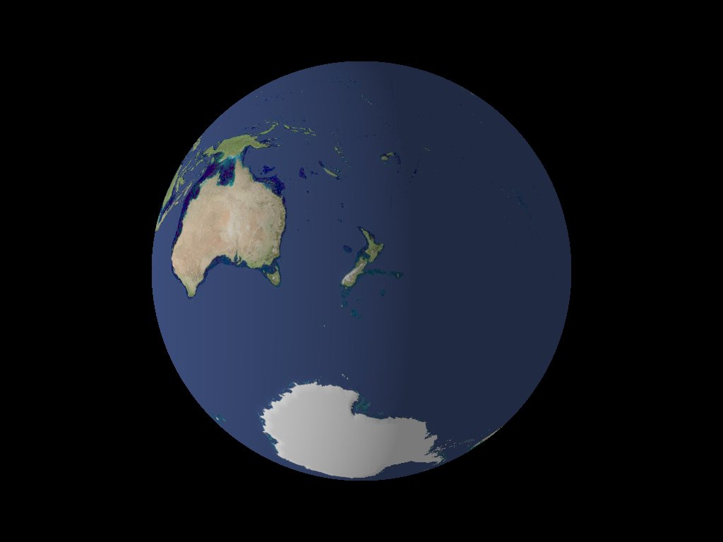
> Her's the Earth, looking at Australia.
>
>
> ------------------------------------------------------------------------
>
Ah, there it is!
Sebastian
Post a reply to this message
|
|
| |
| |
|
|
|
|
| |
| |
|
|
Wa ha, figured it out...use translate before the warp. :3
--
Tim Cook
http://home.bellsouth.net/p/PWP-empyrean
-----BEGIN GEEK CODE BLOCK-----
Version: 3.12
GFA dpu- s: a?-- C++(++++) U P? L E--- W++(+++)>$
N++ o? K- w(+) O? M-(--) V? PS+(+++) PE(--) Y(--)
PGP-(--) t* 5++>+++++ X+ R* tv+ b++(+++) DI
D++(---) G(++) e*>++ h+ !r--- !y--
------END GEEK CODE BLOCK------
Post a reply to this message
|
|
| |
| |
|
|
|
|
| |
| |
|
|
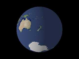
Tim Cook <z99### [at] bellsouth net> wrote:
> Her's the Earth, looking at Australia.
Funny,
I'm going to leave the discussion topic a bit, but
just by chance I downloaded the 8km/pixel file of July before I read this
thread. And as all these Blue Marble pictures are Mercator projections, I
thought it was a good idea to...
Well, two continents one thought...
The original satellite image was more a _Black_ Marble to me, so I made it a
bit lighter (Photopaint).
But when I saw your image I thought: "Hey let's give the NZers a chance!",
and changed from my home coordinates:
// Latitude
//rotate 9.93948843330146 * y // East is Plus
// Longitude
//rotate -53.584204427898 * x // North is Minus
To the coords of Christchurch
rotate (-90 + 172.66) * y
rotate 43.5 * x
But anyway, I've got two questions:
These deep sea trenches west of Australia won't show up. Did you made them
afterwards?
And how did you do the athmosperic rim - a second sphere filled with media?
Yours,
Bu. net> wrote:
> Her's the Earth, looking at Australia.
Funny,
I'm going to leave the discussion topic a bit, but
just by chance I downloaded the 8km/pixel file of July before I read this
thread. And as all these Blue Marble pictures are Mercator projections, I
thought it was a good idea to...
Well, two continents one thought...
The original satellite image was more a _Black_ Marble to me, so I made it a
bit lighter (Photopaint).
But when I saw your image I thought: "Hey let's give the NZers a chance!",
and changed from my home coordinates:
// Latitude
//rotate 9.93948843330146 * y // East is Plus
// Longitude
//rotate -53.584204427898 * x // North is Minus
To the coords of Christchurch
rotate (-90 + 172.66) * y
rotate 43.5 * x
But anyway, I've got two questions:
These deep sea trenches west of Australia won't show up. Did you made them
afterwards?
And how did you do the athmosperic rim - a second sphere filled with media?
Yours,
Bu.
Post a reply to this message
Attachments:
Download 'nzers.jpg' (30 KB)
Preview of image 'nzers.jpg'
|
|
| |
| |
|
|
|
|
| |
| |
|
|
Burki wrote:
> I'm going to leave the discussion topic a bit, but
> just by chance I downloaded the 8km/pixel file of July before I read this
> thread. And as all these Blue Marble pictures are Mercator projections, I
> thought it was a good idea to...
They're not Mercator projections, they're spherical. (Mercator
projections are progressively distorted vertically as you approach the
poles, and approach infinity at the poles themselves.)
> But anyway, I've got two questions:
> These deep sea trenches west of Australia won't show up. Did you made them
> afterwards?
I made a second function of the bathymetric data and added that to the
earth isosurface, where the function with the topography is subtracted,
since they're two files each with a full 256 shades of grey and it's a
shame to not use that full amount by trying to combine the two images
into one, which would reduce the vertical resolution by half.
> And how did you do the athmosperic rim - a second sphere filled with media?
Yep. I outline the important particulars in my 'not oops' post dated
2005-11-10 08:53.
--
Tim Cook
http://home.bellsouth.net/p/PWP-empyrean
-----BEGIN GEEK CODE BLOCK-----
Version: 3.12
GFA dpu- s: a?-- C++(++++) U P? L E--- W++(+++)>$
N++ o? K- w(+) O? M-(--) V? PS+(+++) PE(--) Y(--)
PGP-(--) t* 5++>+++++ X+ R* tv+ b++(+++) DI
D++(---) G(++) e*>++ h+ !r--- !y--
------END GEEK CODE BLOCK------
Post a reply to this message
|
|
| |
| |
|
|
|
|
| |
| |
|
|
Among other things, Tim Cook saw fit to write:
> I made a second function of the bathymetric data and added that to the
> earth isosurface, where the function with the topography is subtracted,
> since they're two files each with a full 256 shades of grey and it's a
> shame to not use that full amount by trying to combine the two images
> into one, which would reduce the vertical resolution by half.
Some time ago, before this new Blue Marble appeared, I got a full
bathymetric and elevation data file frome somewhere (I don't remember the
URL or the resolution, but it was acceptable[*]). The original data was a
binary no-header 16-bit file, which I converted to pgm with some effort
(involving using sox for getting the correct byte ending), as at that time
POV-Ray didn't support reading 16-bit PNG files... This all goes to say
that you can in theory combine everything in a 16-bit file without losing
resolution, or even get the whole thing with higher resolution.
[*] I may have the file somewhere and could put it in a server if someone is
interested.
--
light_source{9+9*x,1}camera{orthographic look_at(1-y)/4angle 30location
9/4-z*4}light_source{-9*z,1}union{box{.9-z.1+x clipped_by{plane{2+y-4*x
0}}}box{z-y-.1.1+z}box{-.1.1+x}box{.1z-.1}pigment{rgb<.8.2,1>}}//Jellby
Post a reply to this message
|
|
| |
| |
|
|
|
|
| |