|
|
|
|
|
|
| |
| |
|
|
|
|
| |
| |
|
|
Mark Wagner wrote:
>
[...]
>
> Allow a user to provide a second greyscale image that specifies the
> "hardness" of parts of the map.
>
> Mark
That's already planned (it's already possible to specify a B/W mask for total
exclusion of certain areas).
The problem is how to generate that map, because in real world the amount of
erosion is influenced by a lot of factors like:
-rock material
-water amount
-slope
-hillside orientation
-most often wind directions
-existing vegetation
-...
Some of these factors can be calculated from the heightfield, some have to be
specified by the user, but for example not every user drawn "geological map" is
possible, it is not reasonable if the material changes from granite to sand just
at the top of a mountain.
Christoph
--
Christoph Hormann <chr### [at] gmx de>
Homepage: http://www.schunter.etc.tu-bs.de/~chris/ de>
Homepage: http://www.schunter.etc.tu-bs.de/~chris/
Post a reply to this message
|
|
| |
| |
|
|
|
|
| |
| |
|
|
That's what I said.
Post a reply to this message
|
|
| |
| |
|
|
|
|
| |
| |
|
|
Ugh, forget I said anything...
--
David Fontaine <dav### [at] faricynet> ICQ 55354965
Please visit my website: http://www.faricy.net/~davidf/
Post a reply to this message
|
|
| |
| |
|
|
|
|
| |
| |
|
|
Just put some more samples on my web page, so if anybody is interested:
http://www.schunter.etc.tu-bs.de/~chris/erosion1.html
I also included an "inverse version" with rounded hills, it does not look as bad
as i thought :-) Maybe I could try out some mixtures...
Christoph
--
Christoph Hormann <chr### [at] gmxde>
Homepage: http://www.schunter.etc.tu-bs.de/~chris/
Post a reply to this message
|
|
| |
| |
|
|
|
|
| |
| |
|
|
That would be a relatively young mountain in your photo.
Christoph Hormann wrote:
> Chris Huff wrote:
> >
> [...]
> >
> > Yes, but they eventually get smoothed over by time and weather. Sharp
> > points and steep sides shear off and the debris accumulates at the
> > bottom, and the mountain becomes more hill-like and rounded.
> > Your filter looks more like a "time machine", reversing the normal
> > erosion process.
> >
>
> It depends on the material, of course hillsides do not get infinitely steep, but
> it can be quite extreme like in the attached photo.
>
> Christoph
>
> --
> Christoph Hormann <chr### [at] gmxde>
> Homepage: http://www.schunter.etc.tu-bs.de/~chris/
>
> ------------------------------------------------------------------------
> [Image]
--
Come visit my web site:-) : http://www.geocities.com/~thomaslake/
Post a reply to this message
|
|
| |
| |
|
|
|
|
| |
| |
|
|
Christoph Hormann wrote:
> It depends on the material, of course hillsides do not get infinitely steep, but
> it can be quite extreme like in the attached photo.
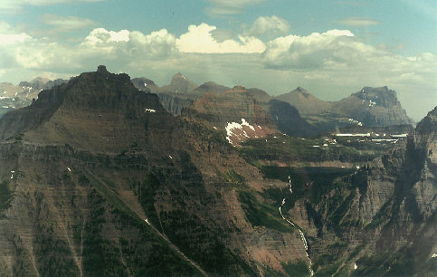
That is an example of water erosion, not wind. I have attached a photo from Glacier
Park to demonstrate...
--
David Fontaine <dav### [at] faricynet> ICQ 55354965
Please visit my website: http://www.faricy.net/~davidf/
Post a reply to this message
Attachments:
Download 'glacierpark.jpg' (43 KB)
Preview of image 'glacierpark.jpg'

|
|
| |
| |
|
|
|
|
| |
| |
|
|
"David Fontaine" <dav### [at] faricynet> wrote in message
news:398DDC5C.2F84F85E@faricy.net...
| Christoph Hormann wrote:
|
| > It depends on the material, of course hillsides do not get infinitely
steep, but
| > it can be quite extreme like in the attached photo.
|
| That is an example of water erosion, not wind. I have attached a photo
from Glacier
| Park to demonstrate...
I had said (and someone else was before me) about how the material being
carried away would make a lot of difference. Good example of that.
Come on now, someone could render a copy of this photo can they not? No
image mapping allowed though.
Bob
Post a reply to this message
|
|
| |
| |
|
|
|
|
| |
| |
|
|
Bob Hughes wrote:
> Come on now, someone could render a copy of this photo can they not? No
> image mapping allowed though.
Someone would be quick to point out that the cloud in the center was
not realistic in appearance. Me for example :)
--
Ken Tyler - 1400+ POV-Ray, Graphics, 3D Rendering, and Raytracing Links:
http://home.pacbell.net/tylereng/index.html http://www.povray.org/links/
Post a reply to this message
|
|
| |
| |
|
|
|
|
| |
| |
|
|
Ken wrote:
> Someone would be quick to point out that the cloud in the center was
> not realistic in appearance. Me for example :)
Yes, you are correct. It only took 28 days, too (look at the post times). I am
immensely proud of my accomplishment. If you look closely, you will also
notice I modelled and very accurately textured some helicopter-window
plexiglass right in front of the camera. Come on, if Gilles can make Wet Bird,
who's to say I can't make this? :-) Of course, I owe a lot of thanks to Nathan
for all the great MegaPOV features.
--
David Fontaine <dav### [at] faricynet> ICQ 55354965
Please visit my website: http://www.faricy.net/~davidf/
Post a reply to this message
|
|
| |
| |
|
|
|
|
| |
| |
|
|
David Fontaine wrote:
>
> That is an example of water erosion, not wind. I have attached a photo from Glacier
> Park to demonstrate...
>
Your pict. shows a lot of different aspects of erosion: on the lower parts,
there is water erosion in "soft materials". I don't see much wind erosion
anywhere.
Most erosion effects on massive mountains IMO are "thermal erosion", meaning the
destruction of the rock structure due to temperature changes. Of course, water
and wind influence these effects in certain ways.
I think both photos show very much of this type of erosion, but it is not easy
to simulate, because it much depends on the internal structure of the rock.
Christoph
--
Christoph Hormann <chr### [at] gmxde>
Homepage: http://www.schunter.etc.tu-bs.de/~chris/
Post a reply to this message
|
|
| |
| |
|
|
|
|
| |