|
|
|
|
|
|
| |
| |
|
|
|
|
| |
| |
|
|
Ahh, here I go again. :-)
I've been working on a macro to create a landscape from an array, with several
different realisatoin types..
This landscape is a two parted thing in a rather high resolution for the array.
200x200 poitns for the land, and 300x300 for the sea. The land is parsed with a
few macros to create heights, and shallows on different points, with a equation
to change theese.
Let me describe it.
First, initzialise the array for the ground. create another, exact duplicate of
this.
in the copy, select a point and "raise" this using the length from this point to
the others, together with a function to "smooth" or in other ways change it.
Then, change the layout so all points are >0. find the highest point, and scale
everything down to the range 0..1 . This will make sure that the diffrerent
functions all have a equal effect on the landscape. After this, add to the big
landscape array.
Doing this with some points, will make the global landscape have several effects
applied to them. Then, I scale all points down to the range 0..1, and create a
output from this. The output is in the scale 0..1 in x,y and z, just like a
heightfield.
I'm still working on this, but may clean it up for a release someday. Currently
I haven't worked on the smooth_triangle output yet.
the sea is a specific hack, not using the same function as the land, but I will
change this so it has the same possibilities.
This method is rather flexible in the resolution, since all coordinates are
applyable to a "virtual" grid, and therefore I can increase the scale of the
arrays, thus getting a higher resolution(more triangles, or whatever).
statistics:
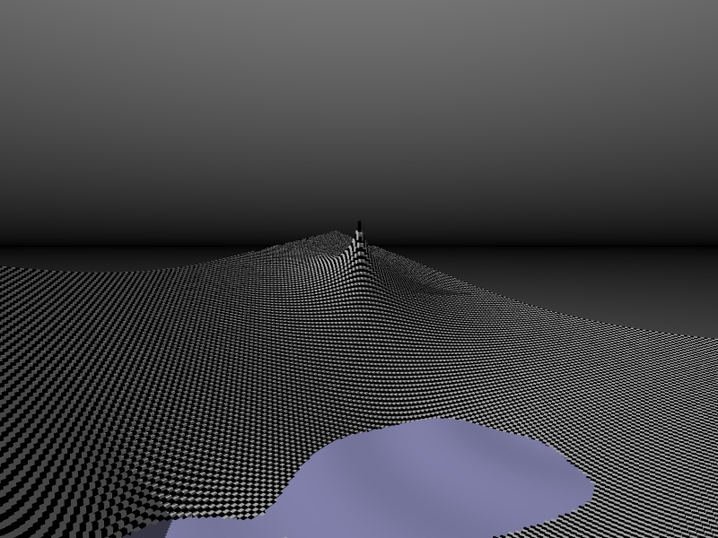
Sea array: 300x300. 177 608 triangles in a mesh. This is totally unecessary.
World array: 200x200, 40000 boxes.
Well, this takes the checker plane into 3D... :-)
as you see, the sea mesh is not necessary, but this was a test render...
And more, I can optimize the other out-puts as well, but I don't really have the
time now. Just giving a slight taste of what I'm working on.
--
//Spider
[ spi### [at] bahnhof se ]-[ http://www.bahnhof.se/~spider/ ]
What I can do and what I could do, I just don't know anymore
"Marian"
By: "Sisters Of Mercy" se ]-[ http://www.bahnhof.se/~spider/ ]
What I can do and what I could do, I just don't know anymore
"Marian"
By: "Sisters Of Mercy"
Post a reply to this message
|
|
| |
| |
|
|
|
|
| |
| |
|
|
More stats:
55 727 714b of memory(Wheee)
parse: 2h 37m 25s
trace: 0h 29m 42s
total: 3h 07m 07s
As you see, the code needs work.
--
//Spider
[ spi### [at] bahnhofse ]-[ http://www.bahnhof.se/~spider/ ]
What I can do and what I could do, I just don't know anymore
"Marian"
By: "Sisters Of Mercy"
Post a reply to this message
Attachments:
Download 'newground2.jpg' (154 KB)
Preview of image 'newground2.jpg'
|
|
| |
| |
|
|
|
|
| |
| |
|
|
Just to give some perspective.
This was in win95, 64mb SDRAM, POV as SHELL
I did another render, without the water mesh.
it took about 60 mins.
Spider wrote:
>
> Ahh, here I go again. :-)
>
> I've been working on a macro to create a landscape from an array, with several
> different realisatoin types..
>
> This landscape is a two parted thing in a rather high resolution for the array.
> 200x200 poitns for the land, and 300x300 for the sea. The land is parsed with a
> few macros to create heights, and shallows on different points, with a equation
> to change theese.
> Let me describe it.
> First, initzialise the array for the ground. create another, exact duplicate of
> this.
> in the copy, select a point and "raise" this using the length from this point to
> the others, together with a function to "smooth" or in other ways change it.
> Then, change the layout so all points are >0. find the highest point, and scale
> everything down to the range 0..1 . This will make sure that the diffrerent
> functions all have a equal effect on the landscape. After this, add to the big
> landscape array.
>
> Doing this with some points, will make the global landscape have several effects
> applied to them. Then, I scale all points down to the range 0..1, and create a
> output from this. The output is in the scale 0..1 in x,y and z, just like a
> heightfield.
>
> I'm still working on this, but may clean it up for a release someday. Currently
> I haven't worked on the smooth_triangle output yet.
>
> the sea is a specific hack, not using the same function as the land, but I will
> change this so it has the same possibilities.
>
> This method is rather flexible in the resolution, since all coordinates are
> applyable to a "virtual" grid, and therefore I can increase the scale of the
> arrays, thus getting a higher resolution(more triangles, or whatever).
>
> statistics:
> Sea array: 300x300. 177 608 triangles in a mesh. This is totally unecessary.
> World array: 200x200, 40000 boxes.
>
> Well, this takes the checker plane into 3D... :-)
>
> as you see, the sea mesh is not necessary, but this was a test render...
> And more, I can optimize the other out-puts as well, but I don't really have the
> time now. Just giving a slight taste of what I'm working on.
>
> --
> //Spider
> [ spi### [at] bahnhofse ]-[ http://www.bahnhof.se/~spider/ ]
> What I can do and what I could do, I just don't know anymore
> "Marian"
> By: "Sisters Of Mercy"
--
//Spider
[ spi### [at] bahnhofse ]-[ http://www.bahnhof.se/~spider/ ]
What I can do and what I could do, I just don't know anymore
"Marian"
By: "Sisters Of Mercy"
Post a reply to this message
|
|
| |
| |
|
|
|
|
| |
| |
|
|
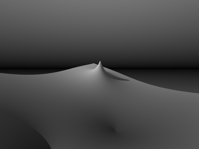
Well, Another image, no sea, and the output as a mesh.
a lower resolution on this image, only 150x150 ..
parse: 7m 29s
render: 1m 18s
total: 8m 48s.
9 355 970bytes used.
Spider wrote:
>
> Ahh, here I go again. :-)
>
> I've been working on a macro to create a landscape from an array, with several
> different realisatoin types..
>
> This landscape is a two parted thing in a rather high resolution for the array.
> 200x200 poitns for the land, and 300x300 for the sea. The land is parsed with a
> few macros to create heights, and shallows on different points, with a equation
> to change theese.
> Let me describe it.
> First, initzialise the array for the ground. create another, exact duplicate of
> this.
> in the copy, select a point and "raise" this using the length from this point to
> the others, together with a function to "smooth" or in other ways change it.
> Then, change the layout so all points are >0. find the highest point, and scale
> everything down to the range 0..1 . This will make sure that the diffrerent
> functions all have a equal effect on the landscape. After this, add to the big
> landscape array.
>
> Doing this with some points, will make the global landscape have several effects
> applied to them. Then, I scale all points down to the range 0..1, and create a
> output from this. The output is in the scale 0..1 in x,y and z, just like a
> heightfield.
>
> I'm still working on this, but may clean it up for a release someday. Currently
> I haven't worked on the smooth_triangle output yet.
>
> the sea is a specific hack, not using the same function as the land, but I will
> change this so it has the same possibilities.
>
> This method is rather flexible in the resolution, since all coordinates are
> applyable to a "virtual" grid, and therefore I can increase the scale of the
> arrays, thus getting a higher resolution(more triangles, or whatever).
>
> statistics:
> Sea array: 300x300. 177 608 triangles in a mesh. This is totally unecessary.
> World array: 200x200, 40000 boxes.
>
> Well, this takes the checker plane into 3D... :-)
>
> as you see, the sea mesh is not necessary, but this was a test render...
> And more, I can optimize the other out-puts as well, but I don't really have the
> time now. Just giving a slight taste of what I'm working on.
>
> --
> //Spider
> [ spi### [at] bahnhofse ]-[ http://www.bahnhof.se/~spider/ ]
> What I can do and what I could do, I just don't know anymore
> "Marian"
> By: "Sisters Of Mercy"
--
//Spider
[ spi### [at] bahnhofse ]-[ http://www.bahnhof.se/~spider/ ]
What I can do and what I could do, I just don't know anymore
"Marian"
By: "Sisters Of Mercy"
Post a reply to this message
Attachments:
Download 'newground2.jpg' (24 KB)
Preview of image 'newground2.jpg'
|
|
| |
| |
|
|
|
|
| |
| |
|
|
Suprisingly smooth. I've had much rougher heightfields using 300x300 gif
images. What kind of fractal chaos you got planned for this thing?
I looked at the other image also. Find it difficult to believe the
resolution is so low.
Spider wrote:
>
> Ahh, here I go again. :-)
>
> I've been working on a macro to create a landscape from an array, with several
> different realisatoin types..
>
> This landscape is a two parted thing in a rather high resolution for the array.
> 200x200 poitns for the land, and 300x300 for the sea. The land is parsed with a
> few macros to create heights, and shallows on different points, with a equation
> to change theese.
> Let me describe it.
> First, initzialise the array for the ground. create another, exact duplicate of
> this.
> in the copy, select a point and "raise" this using the length from this point to
> the others, together with a function to "smooth" or in other ways change it.
> Then, change the layout so all points are >0. find the highest point, and scale
> everything down to the range 0..1 . This will make sure that the diffrerent
> functions all have a equal effect on the landscape. After this, add to the big
> landscape array.
>
> Doing this with some points, will make the global landscape have several effects
> applied to them. Then, I scale all points down to the range 0..1, and create a
> output from this. The output is in the scale 0..1 in x,y and z, just like a
> heightfield.
>
> I'm still working on this, but may clean it up for a release someday. Currently
> I haven't worked on the smooth_triangle output yet.
>
> the sea is a specific hack, not using the same function as the land, but I will
> change this so it has the same possibilities.
>
> This method is rather flexible in the resolution, since all coordinates are
> applyable to a "virtual" grid, and therefore I can increase the scale of the
> arrays, thus getting a higher resolution(more triangles, or whatever).
>
> statistics:
> Sea array: 300x300. 177 608 triangles in a mesh. This is totally unecessary.
> World array: 200x200, 40000 boxes.
>
> Well, this takes the checker plane into 3D... :-)
>
> as you see, the sea mesh is not necessary, but this was a test render...
> And more, I can optimize the other out-puts as well, but I don't really have the
> time now. Just giving a slight taste of what I'm working on.
>
> --
> //Spider
> [ spi### [at] bahnhofse ]-[ http://www.bahnhof.se/~spider/ ]
> What I can do and what I could do, I just don't know anymore
> "Marian"
> By: "Sisters Of Mercy"
--
omniVERSE: beyond the universe
http://members.aol.com/inversez/homepage.htm
mailto:inv### [at] aolcom?Subject=PoV-News
Post a reply to this message
|
|
| |
| |
|
|
|
|
| |
| |
|
|
I'm curious too ! How did you generate the heights ? For the landscape include file I
did,
I'm using a "Perlin noise"-like method and added the option of declaring control
points but I
am not very pleased by the result.
For the water, do you make like the water_level ? I was looking for a way to add water
where I want and at the height I want but I didn't find it. So, I made it ! The
problem is to
calculate the height of a point on a 3D triangle. The method I'm using is not very
efficient, have
you got such a function in your generator ?
If you want to see an example, look at the image "Height-field and smooth
triangles".16/3/99
Again, excellent result !
David GEMELLI
Post a reply to this message
|
|
| |
| |
|
|
|
|
| |
| |
|
|
Whoooa. Got back (home(my puter)) again.
Explanations :-)
The new(planned...) output will be in a unit-sized object, as the HF.
This is for ease of scaling into intersections and so on.
well, internally, I intend to use a factor of 1000, so I don't get problems with
the decimal loss in some functions.
Moreover.
There was a question about the algorithm(fractal)
it isn't fractal based at all, but uses a placed position landscape.
that is, (this is what I am planning) :
point(<1/4, 4/5>, -0.5, "Linear")
This will place a point at 1/4th of the width, and 4/5th of the length(depth) of
the landscape. it will be sunken with 0.5 as the multiplier, and will use a
linear(instead of a logarithmic) curve.
This isn't what I have at the moment, but will come pretty close to the final
version.
As for randomizations and so on, I plan to add a "average" and a "noise"
function, as well as a plasma generation(WHY should you use this instead of a
plasma generator and a HF?)
More questions, or even better... IDEAS !!!
--
//Spider
[ spi### [at] bahnhofse ]-[ http://www.bahnhof.se/~spider/ ]
What I can do and what I could do, I just don't know anymore
"Marian"
By: "Sisters Of Mercy"
Post a reply to this message
|
|
| |
| |
|
|
|
|
| |
|
|