|
|
|
|
|
|
| |
| |
|
|
|
|
| |
| |
|
|
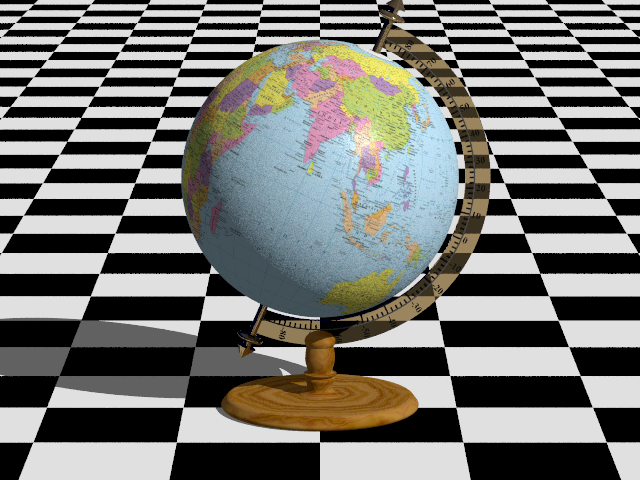
It irritates me when I see a flat map mapped incorrectly onto a globe.
It seems to be a symptom of people having grown up with Mercator maps,
and never learning the correct relative sizes of land masses. I've seen
this done several times in professional settings, and I don't know
whether the CGI people actually don't know what a globe is supposed to
look like, or that they *do* know, and they're deliberately doing it
wrong because they know that their *audience* doesn't know what a globe
is supposed to look like.
But I'm sure that in Chris Bartlett's case, it was the former.
About 10 years ago, I left a feedback comment with the correct mapping
on the Object Collection website, but by then Chris was no longer around
to see it. I finally decided to rectify the error myself:
https://github.com/CousinRicky/POV-TheEarth
Post a reply to this message
|
|
| |
| |
|
|
|
|
| |
| |
|
|
Op 9-12-2023 om 16:16 schreef Cousin Ricky:
> https://github.com/CousinRicky/POV-TheEarth
Excellent initiative. Thank you very much indeed.
--
Thomas
Post a reply to this message
|
|
| |
| |
|
|
|
|
| |
| |
|
|
On 09/12/2023 16:16, Cousin Ricky wrote:
> It irritates me when I see a flat map mapped incorrectly onto a globe.
> It seems to be a symptom of people having grown up with Mercator maps,
> and never learning the correct relative sizes of land masses. I've seen
> this done several times in professional settings, and I don't know
> whether the CGI people actually don't know what a globe is supposed to
> look like, or that they *do* know, and they're deliberately doing it
> wrong because they know that their *audience* doesn't know what a globe
> is supposed to look like.
>
> But I'm sure that in Chris Bartlett's case, it was the former.
>
> About 10 years ago, I left a feedback comment with the correct mapping
> on the Object Collection website, but by then Chris was no longer around
> to see it. I finally decided to rectify the error myself:
>
> https://github.com/CousinRicky/POV-TheEarth
>
I think the problem comes from the software used, which nowadays allows
all kinds of projections. The people who use this software don't really
know what this or that option corresponds to. Just right-click and it's
mapped...
Anyway, thanks for the correction.
--
Kurtz le pirate
Compagnie de la Banquise
Post a reply to this message
|
|
| |
| |
|
|
|
|
| |
| |
|
|
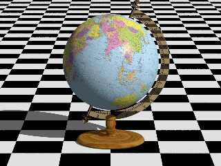
On 09/12/2023 11:16 PM, Cousin Ricky wrote:
> It irritates me when I see a flat map mapped incorrectly onto a globe.
Anybody know a source for political map(s) with the correct projection,
that I can use for a globe?
(This one I know is wrong)
Thanks,
m@
Post a reply to this message
Attachments:
Download 'globe 01.png' (201 KB)
Preview of image 'globe 01.png'
|
|
| |
| |
|
|
|
|
| |
| |
|
|
hi,
Cousin Ricky <ric### [at] yahoo com> wrote:
> It irritates me when I see a flat map mapped incorrectly onto a globe.
> ...
> About 10 years ago, I left a feedback comment with the correct mapping
> on the Object Collection website, but by then Chris was no longer around
> to see it. I finally decided to rectify the error myself:
quick update on the OC. your comment is still there, see attached :-). the OC
is running, has been for a while, albeit on a development machine. RL and
circumstances added unavoidable delays (on both sides). a couple of "other
issues" are pending still, however, getting 'lib.povray' online again is a
priority for me/us, and should happen early next year.
regards, jr. com> wrote:
> It irritates me when I see a flat map mapped incorrectly onto a globe.
> ...
> About 10 years ago, I left a feedback comment with the correct mapping
> on the Object Collection website, but by then Chris was no longer around
> to see it. I finally decided to rectify the error myself:
quick update on the OC. your comment is still there, see attached :-). the OC
is running, has been for a while, albeit on a development machine. RL and
circumstances added unavoidable delays (on both sides). a couple of "other
issues" are pending still, however, getting 'lib.povray' online again is a
priority for me/us, and should happen early next year.
regards, jr.
Post a reply to this message
Attachments:
Download 'screenshot 2023-12-10 05.41.25.png' (164 KB)
Preview of image 'screenshot 2023-12-10 05.41.25.png'
|
|
| |
| |
|
|
|
|
| |
| |
|
|
Cousin Ricky <ric### [at] yahoocom> wrote:
> It irritates me when I see a flat map mapped incorrectly onto a globe.
So, having looked into inversive geometry, stereographic projection, Mobius
transforms, etc. - I think I recall seeing some examples of slightly different
ways of projecting the sphere's surface onto a plane.
Not having delved into this topic to any real extent, are there different image
maps that might not result in a correctly mapped sphere?
Or is the main problem just the cylindrical vs uv-mapping in the scene?
Also just curious if the sphere got scaled to be an oblate spheroid.
- BW
Post a reply to this message
|
|
| |
| |
|
|
|
|
| |
| |
|
|
On 2023-12-10 10:13 (-4), Bald Eagle wrote:
>
> So, having looked into inversive geometry, stereographic projection, Mobius
> transforms, etc. - I think I recall seeing some examples of slightly different
> ways of projecting the sphere's surface onto a plane.
I suspect that there are an infinite number of such projections.
> Not having delved into this topic to any real extent, are there different image
> maps that might not result in a correctly mapped sphere?
It all depends on the projection algorithms.
> Or is the main problem just the cylindrical vs uv-mapping in the scene?
In this particular case, it's just cylindrical vs uv-mapping. The
images were created in the equidistant cylindrical projection, so that
is what I had to work with.
> Also just curious if the sphere got scaled to be an oblate spheroid.
The sphere is not scaled. To account for oblateness, I'd have to know
whether the maps were prepared with geocentric or geodedic latitudes,
and *then* I'd have to remember how I handled the difference 30 years
ago when I worked on USAF satellites. And then a function would have to
be applied to distort the image map in the north-south orientation.
My head is already starting to hurt.
Post a reply to this message
|
|
| |
| |
|
|
|
|
| |
| |
|
|
Cousin Ricky <ric### [at] yahoocom> wrote:
> The sphere is not scaled. To account for oblateness, I'd have to know
> whether the maps were prepared with geocentric or geodedic latitudes,
> and *then* I'd have to remember how I handled the difference 30 years
> ago when I worked on USAF satellites. And then a function would have to
> be applied to distort the image map in the north-south orientation.
>
> My head is already starting to hurt.
Oh yeah - I remember when Mike Horvath was doing stuff with that, and I looked
into it, and said, "Nope."
https://news.povray.org/povray.binaries.animations/thread/%3C5b57aea2%241%40news.povray.org%3E/
https://news.povray.org/povray.general/thread/%3C5b511771%241%40news.povray.org%3E/?mtop=423543
I have gained a significant appreciation for how hairy things get once they go
ellipsoidal. ;)
- BW
Post a reply to this message
|
|
| |
| |
|
|
|
|
| |
| |
|
|
Op 10/12/2023 om 18:42 schreef Cousin Ricky:
> On 2023-12-10 10:13 (-4), Bald Eagle wrote:
>>
>> So, having looked into inversive geometry, stereographic projection, Mobius
>> transforms, etc. - I think I recall seeing some examples of slightly different
>> ways of projecting the sphere's surface onto a plane.
>
> I suspect that there are an infinite number of such projections.
>
>> Not having delved into this topic to any real extent, are there different image
>> maps that might not result in a correctly mapped sphere?
>
> It all depends on the projection algorithms.
>
>> Or is the main problem just the cylindrical vs uv-mapping in the scene?
>
> In this particular case, it's just cylindrical vs uv-mapping. The
> images were created in the equidistant cylindrical projection, so that
> is what I had to work with.
>
>> Also just curious if the sphere got scaled to be an oblate spheroid.
>
> The sphere is not scaled. To account for oblateness, I'd have to know
> whether the maps were prepared with geocentric or geodedic latitudes,
> and *then* I'd have to remember how I handled the difference 30 years
> ago when I worked on USAF satellites. And then a function would have to
> be applied to distort the image map in the north-south orientation.
>
> My head is already starting to hurt.
>
>
Naively, I had never realised things were this /hairy/ at all when I
simply applied NASA maps of Earth or planets to simple spheres....
I even more appreciate your work on this.
--
Thomas
Post a reply to this message
|
|
| |
| |
|
|
|
|
| |
| |
|
|
Cousin Ricky <ric### [at] yahoocom> wrote:
> On 2023-12-10 10:13 (-4), Bald Eagle wrote:
> >
> > So, having looked into inversive geometry, stereographic projection, Mobius
> > transforms, etc. - I think I recall seeing some examples of slightly different
> > ways of projecting the sphere's surface onto a plane.
>
> I suspect that there are an infinite number of such projections.
>
> > Not having delved into this topic to any real extent, are there different image
> > maps that might not result in a correctly mapped sphere?
>
> It all depends on the projection algorithms.
>
> > Or is the main problem just the cylindrical vs uv-mapping in the scene?
>
> In this particular case, it's just cylindrical vs uv-mapping. The
> images were created in the equidistant cylindrical projection, so that
> is what I had to work with.
>
> > Also just curious if the sphere got scaled to be an oblate spheroid.
>
> The sphere is not scaled. To account for oblateness, I'd have to know
> whether the maps were prepared with geocentric or geodedic latitudes,
> and *then* I'd have to remember how I handled the difference 30 years
> ago when I worked on USAF satellites. And then a function would have to
> be applied to distort the image map in the north-south orientation.
>
> My head is already starting to hurt.
Great endeavor !
Indeed, almost as many projection systems... (That's how these calculations are
called in the GIS field (Geographical Information Systems aka modern
cartography))...As there are countries,
(https://en.wikipedia.org/wiki/Map_projection) not even counting the vertical
projection systems.
Each country wants to minimize distortions in its area. The world's shape is
also not much more of a sphere than a potato can be (latitudes vs longitudes
lengths, or Himalayas vs japan's deep seas) so for instance in France use the
Lambert 93 projection. And it's already a good thing that all of the country is
normalized to use the same.
Just as much as the language that "won" for international exchanges is English,
The encoding UTF8...
The projection that did so is WGS84
(https://en.wikipedia.org/wiki/World_Geodetic_System#WGS84)
So that's what anything without specified system is expected to be using (GPS,
etc...).
The awesome free software QGIS can convert between projections.
the hard thing for non specialists is to know were to look for the projection
system of some data when not specified, before converting it and not tempering
too much to avoid corrupting it.
The first thing to do is to search for a file next to the graphical data such as
a TIFF image. it could for instance be a file with the same name but ending with
*.PRJ
the other thing to do whether you have that file around or not is to look at the
numbers for coordinates of one entity in your data : opening it, selecting it,
zooming to it, moving cursor around, whatever software will always show you some
couple or tuple of numbers.
The X and Y value of a point, for a given projection will always be comprised
within some bounding limits in the country accustomed to use it again, in e.g.
France is within:
0 000 000>X>1 300 000
6 000 000>Y>7 200 000
(not that it matters but all in meters)
In fact if you actually know where this point is supposed to be, and provided no
data corruption has occurred, you can identify the original projection of some
data by entering its coordinates in the below tool, and choosing the point that
comes up at its right place:
https://app.dogeo.fr/Projection/#/point-to-coords
That's all folks ! enjoy your open data !
Post a reply to this message
|
|
| |
| |
|
|
|
|
| |
|
|