|
|
|
|
|
|
| |
| |
|
|
|
|
| |
| |
|
|
And I get slightly different results when I pipe the original east or
west rendering into the macro.
I think Paint Shop Pro is not doing a very good job at maintaining PNG
fidelity when I combine the two halves. Blarg.
Maybe paint.net will be better.
--
Tim Cook
http://empyrean.sjcook.com
Post a reply to this message
|
|
| |
| |
|
|
|
|
| |
| |
|
|
Tim Cook <z99### [at] gmail com> wrote:
> On 2012-10-17 17:33, Samuel Benge wrote:
> > If none of that works, would you mind posting your entire height map so I can
> > figure out what's going wrong?
>
> The original height map I rendered at 7200x4800, so it's a 2.4 MB png,
> here's the reduced-size version. (Ehm, re-rendered...oh hey, I had
> jitter 'on' in the antialiasing options there, that might've been
> contributing to the noise level, let's see what it turns out with that
> off.) *waits*
>
> Here we go.
Thanks, I'll see how it works out over here.
I noticed that your map uses elements of varying resolutions. Some parts are
sharp, while others are quite pixelated. That could be a big source of your
problems. AFAICT, noise reduction schemes assume that the noise is at or near
the pixel level (ie. sudden changes occur from one pixel to the next). If abrupt
changes occur over several pixels, you're going to have problems trying to
smooth things out.
There must be a magnification filter somewhere that can smooth the transitions,
like some sort of HQNx filter for height maps.
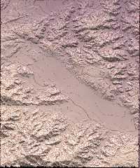
> Ah! A problem your macro doesn't take into account (not sure how it
> would, either, but who knows?) is that of depressions, where a given
> contour line loop isn't an ascending hill, but a shallower area.
It should. The attached render uses a converted and eroded digital elevation
model of Morongo Valley, CA (elevation lines were arbitrarily chosen). Near the
far upper right you can just make out an irregular depression ringed by a blue
line. Depressions in the desert aren't easy to come by--all the water flows down
hills and ravines--and consequently that is the only one I have found on this
particular map so far.
My macro takes everything literally, so a line is just as likely to loop around
a depression as it is a hill, it's just that depressions are less common and
might be missed if the spacing is too wide. com> wrote:
> On 2012-10-17 17:33, Samuel Benge wrote:
> > If none of that works, would you mind posting your entire height map so I can
> > figure out what's going wrong?
>
> The original height map I rendered at 7200x4800, so it's a 2.4 MB png,
> here's the reduced-size version. (Ehm, re-rendered...oh hey, I had
> jitter 'on' in the antialiasing options there, that might've been
> contributing to the noise level, let's see what it turns out with that
> off.) *waits*
>
> Here we go.
Thanks, I'll see how it works out over here.
I noticed that your map uses elements of varying resolutions. Some parts are
sharp, while others are quite pixelated. That could be a big source of your
problems. AFAICT, noise reduction schemes assume that the noise is at or near
the pixel level (ie. sudden changes occur from one pixel to the next). If abrupt
changes occur over several pixels, you're going to have problems trying to
smooth things out.
There must be a magnification filter somewhere that can smooth the transitions,
like some sort of HQNx filter for height maps.
> Ah! A problem your macro doesn't take into account (not sure how it
> would, either, but who knows?) is that of depressions, where a given
> contour line loop isn't an ascending hill, but a shallower area.
It should. The attached render uses a converted and eroded digital elevation
model of Morongo Valley, CA (elevation lines were arbitrarily chosen). Near the
far upper right you can just make out an irregular depression ringed by a blue
line. Depressions in the desert aren't easy to come by--all the water flows down
hills and ravines--and consequently that is the only one I have found on this
particular map so far.
My macro takes everything literally, so a line is just as likely to loop around
a depression as it is a hill, it's just that depressions are less common and
might be missed if the spacing is too wide.
Post a reply to this message
Attachments:
Download 'mv-topo.jpg' (272 KB)
Preview of image 'mv-topo.jpg'
|
|
| |
| |
|
|
|
|
| |
| |
|
|
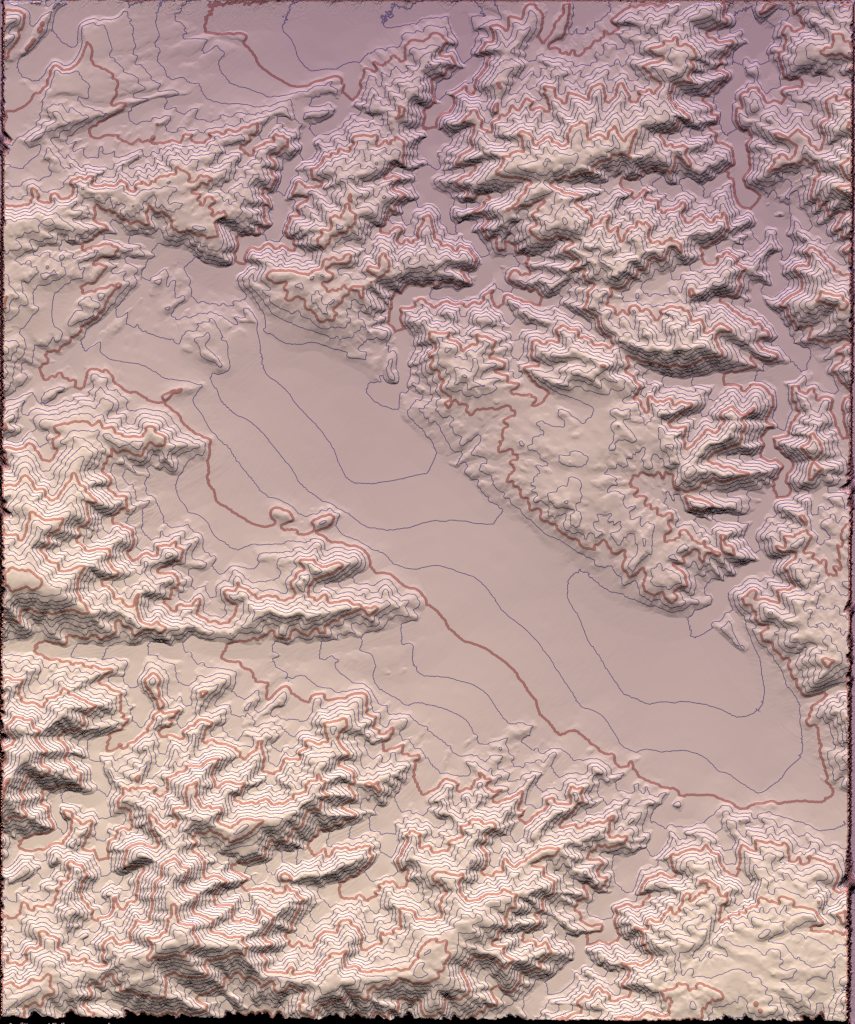
"Samuel Benge" <stb### [at] hotmailcom> wrote:
> Tim Cook <z99### [at] gmailcom> wrote:
> > The original height map I rendered at 7200x4800, so it's a 2.4 MB png,
> > here's the reduced-size version.
>
> Thanks, I'll see how it works out over here.
Attached is an image combining contour lines from "tamrielheightsmall.png"
superimposed onto your relief map. The lines seem to behaving themselves. Is
this anywhere near what you wanted? I sure hope I haven't sent you on a wild
goose chase!
Here's the POV scene used to trace it:
// +fn +f +a0.1 +am2 +r3 +w1600 +h1067
#version 3.7;
global_settings{assumed_gamma 1.0}
#default{ finish{ ambient 1 } }
camera{
orthographic
right x*2 up y*2
location -z
look_at 0
}
#macro Pg_Elevation_Lines(PgInput, NLines, LineSize, Quality, LineOffs,
LineSmoothing)
#local Quality = max(1, int(Quality*LineSize));
#macro SampleLoop(Param)
max(
0
#for(N, 1, Quality)
#local C = 1/Quality*N;
#local R = pow(C*sqrt(N)/pow(Quality,.5),1/3);
#local Angle = N*137.508;
#local Pt = vrotate(y*R, z*Angle);
#local PtX = Pt.x*LineSizeX;
#local PtY = Pt.y*LineSizeY;
#if(Param)
, (1-R*LineSmoothing)*(1-FInput(x+PtX, y+PtY, 0))
#else
, (1-R*LineSmoothing)*FInput(x+PtX, y+PtY, 0)
#end
#end
)
#end
#local FInput =
function{
pattern{
pigment_pattern{
PgInput
phase 1-LineOffs/2
frequency NLines/2
color_map{
[.5 rgb 0]
[.5 rgb 1]
}
}
}
}
pigment_pattern{
#local LineSizeX = LineSize/image_width;
#local LineSizeY = LineSize/image_height;
function{
SampleLoop(1)*(FInput(x, y, 0)=1)
+
SampleLoop(0)*(FInput(x, y, 0)=0)
}
cubic_wave
warp{planar}
}
#end // Pg_Elevation_Lines
// map relief
plane{
z, 1
pigment{
average
pigment_map{
[.5 rgb 1]
[1
image_map{
"skyrim shaded relief low.jpg"
interpolate 2
}
scale 2
translate -1
]
}
}
}
// contour lines overlay
plane{z, 0
#declare InputPigment =
pigment{
image_pattern{
"tamrielheightsmall.png"
interpolate 2
}
scale 2
translate -1
}
pigment{
#declare NLines = 11;
Pg_Elevation_Lines( InputPigment, NLines, 3, 8, 0, off )
pigment_map{
[0
Pg_Elevation_Lines( InputPigment, NLines*5, 1.5, 8, 0, off)
pigment_map{
[0 rgb 0 transmit 1]
[1 rgb 0 transmit .5]
}
]
[1 rgb 0 transmit .5]
}
}
}
Post a reply to this message
Attachments:
Download 'tamriel-contours.jpg' (344 KB)
Preview of image 'tamriel-contours.jpg'
|
|
| |
| |
|
|
|
|
| |
| |
|
|
"Samuel Benge" <stb### [at] hotmailcom> wrote:
> Attached is an image combining contour lines from "tamrielheightsmall.png"
> superimposed onto your relief map.
Tim, I must mention that I thickened every fifth line, just in case you were
wondering why their widths vary :)
Post a reply to this message
|
|
| |
| |
|
|
|
|
| |
| |
|
|
On 2012-10-17 20:20, Samuel Benge wrote:
> I noticed that your map uses elements of varying resolutions. Some parts are
> sharp, while others are quite pixelated.
I know...the underwater areas at the upper-left in particular are much
lower resolution than other places, and that's purely game-data issue.
I guess they thought nobody'd notice.
> My macro takes everything literally, so a line is just as likely to loop around
> a depression as it is a hill, it's just that depressions are less common and
> might be missed if the spacing is too wide.
That's what I meant; if you have a donut-shaped hill, so that it has two
concentric rings that are actually the same altitude, with the centre
being a divot, it will look identical to a hill that's taller and
crosses the next elevation line up.
Any way of checking the slope direction/comparing the height
before/after the contour line, then generating perpendicular
inward-pointing ticks for depressions?
XD
--
Tim Cook
http://empyrean.sjcook.com
Post a reply to this message
|
|
| |
| |
|
|
|
|
| |
| |
|
|
On 2012-10-17 21:19, Samuel Benge wrote:
> Attached is an image combining contour lines from "tamrielheightsmall.png"
> superimposed onto your relief map. The lines seem to behaving themselves. Is
> this anywhere near what you wanted? I sure hope I haven't sent you on a wild
> goose chase!
>
> Here's the POV scene used to trace it:
Oh...my. That's smexy. Think you did some modification to your macro
to do the index contours plus regulars from the version I snagged, v. nice.
Now to get to the minor tweaking. Running this at a stoopid-high
resolution, adding the shorelines/waterways, labelling...
--
Tim Cook
http://empyrean.sjcook.com
Post a reply to this message
|
|
| |
| |
|
|
|
|
| |
| |
|
|
> It should. The attached render uses a converted and eroded digital elevation
> model of Morongo Valley, CA (elevation lines were arbitrarily chosen).
This is an interesting render.
Paolo
Post a reply to this message
|
|
| |
| |
|
|
|
|
| |
| |
|
|
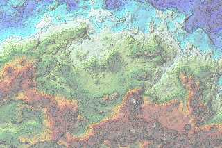
So, with the gracious assistance of Mr. Benge, I have been able to
progress by leaps and bounds, adding the initial pass of roads
(transcribed from the mod that adds those to the world map). I have
made some minor adjustments to make the roads better fit the terrain,
but not many; somewhat surprisingly (to me, at least), the roads in
Skyrim follow the contours of the land in a way that makes sense. Usually.
I had rendered the contour lines a bit light, I need to either rerender
or adjust in another layer. The landmark icons are the in-game ones,
and I need to verify/correct their locations, and replace them with
appropriate 'real' map symbols (or things that look as such). Think I
need to check on some of the roads, too, but...it's a great deal further
along than I had hoped to be.
When this is complete, the next logical stage will be to render the rest
of the terrain data and make a mod for Skyrim to display the topography
in its world map.
--
Tim Cook
http://empyrean.sjcook.com
Post a reply to this message
Attachments:
Download '2456219 skyrim topo.jpg' (946 KB)
Preview of image '2456219 skyrim topo.jpg'
|
|
| |
| |
|
|
|
|
| |
| |
|
|
Awesome.
Thomas
Post a reply to this message
|
|
| |
| |
|
|
|
|
| |
| |
|
|
>Tim Cook on date 18/10/2012 19.28 wrote:
> So, with the gracious assistance of Mr. Benge, I have been able to
> progress by leaps and bounds, adding the initial pass of roads
> (transcribed from the mod that adds those to the world map). I have
> made some minor adjustments to make the roads better fit the terrain,
> but not many; somewhat surprisingly (to me, at least), the roads in
> Skyrim follow the contours of the land in a way that makes sense. Usually.
>
> I had rendered the contour lines a bit light, I need to either rerender
> or adjust in another layer. The landmark icons are the in-game ones,
> and I need to verify/correct their locations, and replace them with
> appropriate 'real' map symbols (or things that look as such). Think I
> need to check on some of the roads, too, but...it's a great deal further
> along than I had hoped to be.
>
> When this is complete, the next logical stage will be to render the rest
> of the terrain data and make a mod for Skyrim to display the topography
> in its world map.
>
> --
> Tim Cook
> http://empyrean.sjcook.com
This is an intriguing map!
Paolo
Post a reply to this message
|
|
| |
| |
|
|
|
|
| |
|
|