|
|
|
|
|
|
| |
| |
|
|
|
|
| |
| |
|
|
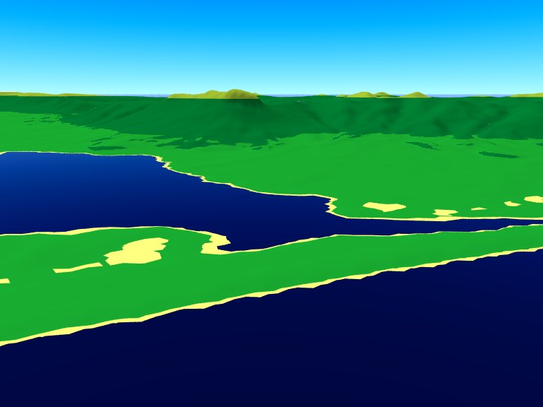
High!
Meanwhile, I got some raw version of the vegetation texture for southern
Tasmania (just a heightfield exercise in between, don't worry, I'll
switch back to Khyberspace as soon as possible!) ready... it consists of
a texture_map containing five texture_maps, each of them again is a
slope pattern containing two or three basic textures:
// Basic textures
#declare T_Beach=
texture
{
pigment { color rgb <1, 1, 0.5> }
finish { ambient 0.05 diffuse 1 brilliance 0.25 }
}
#declare T_Meadow=
texture
{
pigment { color rgb <0.1, 0.7, 0.2> }
finish { ambient 0.05 diffuse 1 brilliance 0.5 }
}
#declare T_Forest=
texture
{
pigment { color rgb <0, 0.5, 0.2> }
finish { ambient 0.05 diffuse 1 brilliance 0.42 }
}
#declare T_Shrub=
texture
{
pigment { color rgb <0.65, 0.78, 0.2> }
finish { ambient 0.05 diffuse 1 brilliance 0.31 }
}
#declare T_Rock=
texture
{
pigment { color rgb 0.7 }
finish { ambient 0.05 diffuse 1 brilliance 0.5 }
}
#declare T_Snow=
texture
{
pigment { color rgb 1 }
finish { ambient 0.05 diffuse 1 brilliance 0.18 }
}
// Slope-patterned texture_maps
#declare TM_Shore=
texture
{
slope { <0, -1, 0> }
texture_map
{
[0 T_Beach ]
[0.2 T_Beach ]
[0.2 T_Forest ]
[0.4 T_Forest ]
[0.4 T_Rock ]
[0.5 T_Rock ]
}
}
#declare TM_Lowlands=
texture
{
slope { <0, -1, 0> }
texture_map
{
[0 T_Meadow ]
[0.06 T_Meadow ]
[0.065 T_Forest ]
[0.4 T_Forest ]
[0.4 T_Rock ]
[0.5 T_Rock ]
}
}
#declare TM_Highlands=
texture
{
slope { <0, -1, 0> }
texture_map
{
[0 T_Forest ]
[0.4 T_Forest ]
[0.4 T_Rock ]
[0.5 T_Rock ]
}
}
#declare TM_SubAlpine=
texture
{
slope { <0, -1, 0> }
texture_map
{
[0 T_Shrub ]
[0.4 T_Shrub ]
[0.4 T_Rock ]
[0.5 T_Rock ]
}
}
#declare TM_Alpine=
texture
{
slope { <0, -1, 0> }
texture_map
{
[0 T_Snow ]
[0.4 T_Snow ]
[0.4 T_Rock ]
[0.5 T_Rock ]
}
}
// Overall texture map
#declare h=max_extent(terrain).y-min_extent(terrain).y;
#declare TMM_Tasmania=
texture
{
gradient y
texture_map
{
[0 TM_Shore]
[h/2/h TM_Shore]
[(h+3)/2/h TM_Shore]
[(h+3)/2/h TM_Lowlands]
[(h+200)/2/h TM_Lowlands]
[(h+200)/2/h TM_Highlands]
[(h+900)/2/h TM_Highlands]
[(h+900)/2/h TM_SubAlpine]
[(h+1200)/2/h TM_SubAlpine]
[(h+1200)/2/h TM_Alpine]
[1 TM_Alpine]
}
scale 2*h
translate -y*h
}
I originally scaled the overall texture_map to double y extent of the
heightfield and than translated it along the y axis to have some scope
for turbulence (otherwise, TM_Alpine would show up along the shores).
Probably I'll redo this, as general turbulence for the whole texture
would yield undesirable results...
Note that with the scene attached below, TM_Alpine does not appear as
the mountains visible from the chosen camera position are not high enough.
But as TMM_Tasmania uses a y gradient without turbulence, the boundary
between TM_Highlands and TM_SubAlpine is unnaturally straight (see image
below) - while keeping a sharp boundary between forest and subalpine
shrub, I would like to have the boundary "patchy" at an intermediate
scale. When I apply a general turbulence to TMM_Tasmania, the constraint
of the "beach" part to the lowest and closest to the sea parts of the
heightfields is lost... and, otherwisely, separating the SubAlpine and
AlpineParts (with a third, transparent texture for the lower regions)
from TMM_Tasmania and superimposing it as a second texture layer won't
work either, as PoV-Ray generally is not able to layer mapped textures...
How do I get a more realistic upper forest line?
See you in Khyberspace!
Yadgar
Post a reply to this message
Attachments:
Download '2010-12-15 southwestern tasmania, take 16.jpg' (36 KB)
Preview of image '2010-12-15 southwestern tasmania, take 16.jpg'

|
|
| |
| |
|
|
|
|
| |
| |
|
|
> High!
>
> Meanwhile, I got some raw version of the vegetation texture for southern
> Tasmania (just a heightfield exercise in between, don't worry, I'll
> switch back to Khyberspace as soon as possible!) ready... it consists of
> a texture_map containing five texture_maps, each of them again is a
> slope pattern containing two or three basic textures:
Low!
This is some project, Yadgar. How long have you been working on it?
--
Regards
Stephen
Post a reply to this message
|
|
| |
| |
|
|
|
|
| |
| |
|
|
High!
On 15.12.2010 13:41, Stephen wrote:
> This is some project, Yadgar. How long have you been working on it?
For about one week... nothing really huge, just to play around with
slope-dependent textures! Perhaps later on, I might add real trees and
other vegetation elements...
See you in Khyberspace!
Yadgar
Post a reply to this message
|
|
| |
| |
|
|
|
|
| |
| |
|
|
> High!
>
> On 15.12.2010 13:41, Stephen wrote:
>
>> This is some project, Yadgar. How long have you been working on it?
>
> For about one week... nothing really huge, just to play around with
> slope-dependent textures! Perhaps later on, I might add real trees and
> other vegetation elements...
>
> See you in Khyberspace!
>
I thought it was part of your Khyberspace project which seems to have
ocupied you for years. (Or so it seems)
--
Regards
Stephen
Post a reply to this message
|
|
| |
| |
|
|
|
|
| |
| |
|
|
news:4d08a592@news.povray.org...
> High!
>
> Meanwhile, I got some raw version of the vegetation texture for southern
> Tasmania (just a heightfield exercise in between, don't worry, I'll
> switch back to Khyberspace as soon as possible!) ready... it consists of
> a texture_map containing five texture_maps, each of them again is a
> slope pattern containing two or three basic textures:
>
> // Basic textures
>
> #declare T_Beach=
> texture
> {
> pigment { color rgb <1, 1, 0.5> }
> finish { ambient 0.05 diffuse 1 brilliance 0.25 }
> }
>
> #declare T_Meadow=
> texture
> {
> pigment { color rgb <0.1, 0.7, 0.2> }
> finish { ambient 0.05 diffuse 1 brilliance 0.5 }
> }
>
> #declare T_Forest=
> texture
> {
> pigment { color rgb <0, 0.5, 0.2> }
> finish { ambient 0.05 diffuse 1 brilliance 0.42 }
> }
>
> #declare T_Shrub=
> texture
> {
> pigment { color rgb <0.65, 0.78, 0.2> }
> finish { ambient 0.05 diffuse 1 brilliance 0.31 }
> }
>
> #declare T_Rock=
> texture
> {
> pigment { color rgb 0.7 }
> finish { ambient 0.05 diffuse 1 brilliance 0.5 }
> }
>
> #declare T_Snow=
> texture
> {
> pigment { color rgb 1 }
> finish { ambient 0.05 diffuse 1 brilliance 0.18 }
> }
>
> // Slope-patterned texture_maps
>
> #declare TM_Shore=
> texture
> {
> slope { <0, -1, 0> }
> texture_map
> {
> [0 T_Beach ]
> [0.2 T_Beach ]
> [0.2 T_Forest ]
> [0.4 T_Forest ]
> [0.4 T_Rock ]
> [0.5 T_Rock ]
> }
> }
>
> #declare TM_Lowlands=
> texture
> {
> slope { <0, -1, 0> }
> texture_map
> {
> [0 T_Meadow ]
> [0.06 T_Meadow ]
> [0.065 T_Forest ]
> [0.4 T_Forest ]
> [0.4 T_Rock ]
> [0.5 T_Rock ]
> }
> }
>
> #declare TM_Highlands=
> texture
> {
> slope { <0, -1, 0> }
> texture_map
> {
> [0 T_Forest ]
> [0.4 T_Forest ]
> [0.4 T_Rock ]
> [0.5 T_Rock ]
> }
> }
>
> #declare TM_SubAlpine=
> texture
> {
> slope { <0, -1, 0> }
> texture_map
> {
> [0 T_Shrub ]
> [0.4 T_Shrub ]
> [0.4 T_Rock ]
> [0.5 T_Rock ]
> }
> }
>
> #declare TM_Alpine=
> texture
> {
> slope { <0, -1, 0> }
> texture_map
> {
> [0 T_Snow ]
> [0.4 T_Snow ]
> [0.4 T_Rock ]
> [0.5 T_Rock ]
> }
> }
>
> // Overall texture map
>
> #declare h=max_extent(terrain).y-min_extent(terrain).y;
>
> #declare TMM_Tasmania=
> texture
> {
> gradient y
> texture_map
> {
> [0 TM_Shore]
> [h/2/h TM_Shore]
> [(h+3)/2/h TM_Shore]
> [(h+3)/2/h TM_Lowlands]
> [(h+200)/2/h TM_Lowlands]
> [(h+200)/2/h TM_Highlands]
> [(h+900)/2/h TM_Highlands]
> [(h+900)/2/h TM_SubAlpine]
> [(h+1200)/2/h TM_SubAlpine]
> [(h+1200)/2/h TM_Alpine]
> [1 TM_Alpine]
> }
> scale 2*h
> translate -y*h
> }
>
> I originally scaled the overall texture_map to double y extent of the
> heightfield and than translated it along the y axis to have some scope
> for turbulence (otherwise, TM_Alpine would show up along the shores).
> Probably I'll redo this, as general turbulence for the whole texture
> would yield undesirable results...
>
> Note that with the scene attached below, TM_Alpine does not appear as
> the mountains visible from the chosen camera position are not high enough.
>
> But as TMM_Tasmania uses a y gradient without turbulence, the boundary
> between TM_Highlands and TM_SubAlpine is unnaturally straight (see image
> below) - while keeping a sharp boundary between forest and subalpine
> shrub, I would like to have the boundary "patchy" at an intermediate
> scale. When I apply a general turbulence to TMM_Tasmania, the constraint
> of the "beach" part to the lowest and closest to the sea parts of the
> heightfields is lost... and, otherwisely, separating the SubAlpine and
> AlpineParts (with a third, transparent texture for the lower regions)
> from TMM_Tasmania and superimposing it as a second texture layer won't
> work either, as PoV-Ray generally is not able to layer mapped textures...
>
> How do I get a more realistic upper forest line?
>
> See you in Khyberspace!
>
> Yadgar
>
Hey, I live in southern Tasmania!!
I dont suppose you could tell me where you got the data for the heightfield?
I'm very interested in recreating the area around my house for starters :)
Then the whole island, that would be sweet!!!
Cheers Dre
Post a reply to this message
|
|
| |
| |
|
|
|
|
| |
| |
|
|
High!
On 15.12.2010 22:53, Dre wrote:
> Hey, I live in southern Tasmania!!
In Hobart?
>
> I dont suppose you could tell me where you got the data for the heightfield?
Look here: http://dds.cr.usgs.gov/srtm/version2_1/SRTM3/Australia/
These are data tiles from a Shuttle Radar Topography Mission (SRTM) in
February 2000, covering the entire land surface of the Earth between
of 3 arcseconds per data point. The name of each file indicates the
geographical coordinates of the *southwestern*, i. e. left lower corner
of the tile. So, you just look up the coordinate range of Tasmania in
your preferred atlas and find the respective tiles.
These tiles are NOT image files, but you can make them visible (and even
generate nice 3-D views, which export also to VRML) with a Windows
freeware called "3DEM". You find 3DEM here:
http://freegeographytools.com/3dem_setup.exe
With 3DEM, you can iron out error pixels (mostly resulting from cloud
cover) with the "Patch missing data" feature - but this works only for
error pixels which have no connection to the tile's edges!
To use them with PoV-Ray, you'll have to export the read-in data tile as
"ASCII terrain matrix". I wrote a POV script which generates a 16-bit
PNG heightfield from these ASCII files - attached here (ascii2png.pov)!
The ASCII files have the height data as number strings at two-digit
accuracy (xxxx.xx), each separated by a blank. PoV-Ray needs the blanks
to be replaced by commas to read the data in properly. If you have
access to Linux with its powerful UNIX console command line tools,
you're fine - just type in:
sed 's/ /,/g' original_file destination_file
and within two seconds, almost 1,5 million blanks are replaced by commas!
Unfortunately, I currently do not know of any Windows tool capable of
doing that job at a comparable speed - common GUI text editors, not to
mention full-fledged word processors toil for hours! But even if you
have no Linux on your computer, you can download a "Live CD" image of a
Debian distribution and burn it - afterwards you'll be able to boot a
proper Linux installation from the disk! If you face problems to write
data on your harddisk (because of missing rights), just try a USB stick
instead, it probably will work!
Note that the size of the data tiles is in fact 1201 by 1201 rather than
1200 x 1200, so adjacent rows and columns would repeat - if you want to
join two or more of your generated PNG heightfields, you'll first have
to remove the easternmost column and southernmost row.
And joining heightfields would be the only way to get rid of the error
pixels which, with the original tiles, lie at the edges. I also wrote a
POV script (png2ascii.pov) to re-export joined heightfields to an ASCII
terrain matrix readable by 3DEM - the software will ask you about the
size and corner coordinates and then you can smooth out the remaining
error pixels.
After exporting them back to ASCII (and, of course, once more replacing
blanks by comma) and finally to PNG, you'll have a faultless heightfield
of your desired area. Note that the creation of the PNG heightfields
required quite at lot of memory, as each "pixel" in fact is a small box
object rendered in an orthographic view without light_source but with
ambient 1 - to do 1200 x 1200 boxes, you should have at least 1.5 GB of RAM!
As the tiles are square degree tiles, the resulting cartographic
projection is cylindrical, so that only along the Equator, the
heightfields give a realistical representation of terrain, while towards
the poles, the terrain is increasingly stretched in west-east direction.
To get an undistorted landscape, you'll have to finally convert the PNG
heightfield into a mesh2 which follows Earth's curvature according to
its geographical coordinates. I also wrote a script to do this
(mesh2writer), but as you see in the example rendering I attached, some
artifacts resulting from floating point inaccuracy show up. To avoid
them, we probably must use Christoph Hormann's IsoCSG include
(http://www.imagico.de/pov/ic/index.html) which is able to convert a
mesh2 into an isosurface!
I added two scripts I wrote to do the conversion from PNG to mesh2 -
mesh2writer.pov which writes the full POV code for the entire mesh (for
parsing speed reasons, the mesh2 is generated only once and then written
to harddisk), and png2mesh2.pov which includes the code written by the
former script and generates the scene from it.
> I'm very interested in recreating the area around my house for starters :)
As the SRTM data tiles mentioned above have an effective resolution of
about 90 metres per data point, you'll be better off with pixeling
heightfield from a scanned-in topographic map, perhaps 1:25,000 (which
can be quite cumbersome work)... but then adjusting it to Earth
curvature would be somewhat difficult, as those maps are based on
geodetic (equal distances between points) rather than geographic
coordinates.
> Then the whole island, that would be sweet!!!
Yes, with Tasmanian Tigers roaming the forests! In fact, I think
Tasmania a very interesting part of the world, as it is located in the
"Roaring Forties", mainly when it comes to vegetation and animals, and I
really would like to visit your island!
See you in Khyberspace!
Yadgar
Post a reply to this message
Attachments:
Download 'us-ascii' (3 KB)
Download 'png2mesh2.pov.txt' (3 KB)
Download 'ascii2png.pov.txt' (1 KB)
Download 'png2ascii.pov.txt' (1 KB)
Download '2010-11-20 afghan highlands south of koh-e baba range, take 1 (yadgar).jpg' (42 KB)
Preview of image '2010-11-20 afghan highlands south of koh-e baba range, take 1 (yadgar).jpg'
|
|
| |
| |
|
|
|
|
| |
| |
|
|
news:4d0a3421@news.povray.org...
> High!
>
> On 15.12.2010 22:53, Dre wrote:
>
>> Hey, I live in southern Tasmania!!
>
> In Hobart?
Yep! Well Kingston actually, 10 minutes away. I work in Hobart city :)
>
>>
>> I dont suppose you could tell me where you got the data for the
>> heightfield?
>
> Look here: http://dds.cr.usgs.gov/srtm/version2_1/SRTM3/Australia/
>
> These are data tiles from a Shuttle Radar Topography Mission (SRTM) in
> February 2000, covering the entire land surface of the Earth between
> of 3 arcseconds per data point. The name of each file indicates the
> geographical coordinates of the *southwestern*, i. e. left lower corner
> of the tile. So, you just look up the coordinate range of Tasmania in
> your preferred atlas and find the respective tiles.
>
> These tiles are NOT image files, but you can make them visible (and even
> generate nice 3-D views, which export also to VRML) with a Windows
> freeware called "3DEM". You find 3DEM here:
> http://freegeographytools.com/3dem_setup.exe
> With 3DEM, you can iron out error pixels (mostly resulting from cloud
> cover) with the "Patch missing data" feature - but this works only for
> error pixels which have no connection to the tile's edges!
>
> To use them with PoV-Ray, you'll have to export the read-in data tile as
> "ASCII terrain matrix". I wrote a POV script which generates a 16-bit
> PNG heightfield from these ASCII files - attached here (ascii2png.pov)!
>
> The ASCII files have the height data as number strings at two-digit
> accuracy (xxxx.xx), each separated by a blank. PoV-Ray needs the blanks
> to be replaced by commas to read the data in properly. If you have
> access to Linux with its powerful UNIX console command line tools,
> you're fine - just type in:
>
> sed 's/ /,/g' original_file destination_file
>
> and within two seconds, almost 1,5 million blanks are replaced by commas!
>
> Unfortunately, I currently do not know of any Windows tool capable of
> doing that job at a comparable speed - common GUI text editors, not to
> mention full-fledged word processors toil for hours! But even if you
> have no Linux on your computer, you can download a "Live CD" image of a
> Debian distribution and burn it - afterwards you'll be able to boot a
> proper Linux installation from the disk! If you face problems to write
> data on your harddisk (because of missing rights), just try a USB stick
> instead, it probably will work!
>
> Note that the size of the data tiles is in fact 1201 by 1201 rather than
> 1200 x 1200, so adjacent rows and columns would repeat - if you want to
> join two or more of your generated PNG heightfields, you'll first have
> to remove the easternmost column and southernmost row.
>
> And joining heightfields would be the only way to get rid of the error
> pixels which, with the original tiles, lie at the edges. I also wrote a
> POV script (png2ascii.pov) to re-export joined heightfields to an ASCII
> terrain matrix readable by 3DEM - the software will ask you about the
> size and corner coordinates and then you can smooth out the remaining
> error pixels.
>
> After exporting them back to ASCII (and, of course, once more replacing
> blanks by comma) and finally to PNG, you'll have a faultless heightfield
> of your desired area. Note that the creation of the PNG heightfields
> required quite at lot of memory, as each "pixel" in fact is a small box
> object rendered in an orthographic view without light_source but with
> ambient 1 - to do 1200 x 1200 boxes, you should have at least 1.5 GB of
> RAM!
>
> As the tiles are square degree tiles, the resulting cartographic
> projection is cylindrical, so that only along the Equator, the
> heightfields give a realistical representation of terrain, while towards
> the poles, the terrain is increasingly stretched in west-east direction.
>
> To get an undistorted landscape, you'll have to finally convert the PNG
> heightfield into a mesh2 which follows Earth's curvature according to
> its geographical coordinates. I also wrote a script to do this
> (mesh2writer), but as you see in the example rendering I attached, some
> artifacts resulting from floating point inaccuracy show up. To avoid
> them, we probably must use Christoph Hormann's IsoCSG include
> (http://www.imagico.de/pov/ic/index.html) which is able to convert a
> mesh2 into an isosurface!
>
> I added two scripts I wrote to do the conversion from PNG to mesh2 -
> mesh2writer.pov which writes the full POV code for the entire mesh (for
> parsing speed reasons, the mesh2 is generated only once and then written
> to harddisk), and png2mesh2.pov which includes the code written by the
> former script and generates the scene from it.
>
>> I'm very interested in recreating the area around my house for starters
>> :)
>
> As the SRTM data tiles mentioned above have an effective resolution of
> about 90 metres per data point, you'll be better off with pixeling
> heightfield from a scanned-in topographic map, perhaps 1:25,000 (which
> can be quite cumbersome work)... but then adjusting it to Earth
> curvature would be somewhat difficult, as those maps are based on
> geodetic (equal distances between points) rather than geographic
> coordinates.
>
>> Then the whole island, that would be sweet!!!
>
> Yes, with Tasmanian Tigers roaming the forests! In fact, I think
> Tasmania a very interesting part of the world, as it is located in the
> "Roaring Forties", mainly when it comes to vegetation and animals, and I
> really would like to visit your island!
>
> See you in Khyberspace!
>
> Yadgar
>
Thanks very much for the very thorough write up. I'm going to take a look
at that data over the weekend and see what I can come up with.
Tasmania is an awesome place, wonderful place to live. Unfortunately a
disease is threatening the Tassie Devils existance (no Tigers btw) so you
better hurry if you want to see them :)
Thanks again for the info, much appreciated!
Cheers Dre
Post a reply to this message
|
|
| |
| |
|
|
|
|
| |
| |
|
|
Am 16.12.2010 23:21, schrieb Dre:
> news:4d0a3421@news.povray.org...
> Yep! Well Kingston actually, 10 minutes away. I work in Hobart city :)
There aren't probably that many other settlements along the southern
coast... I've heard of another relatively large town called Launceston,
but it's located in the hinterland (on the Derwent river?) -
unfortunately, I don't have a large-scale map of Tasmania in handy!
> Thanks very much for the very thorough write up. I'm going to take a look
> at that data over the weekend and see what I can come up with.
>
> Tasmania is an awesome place, wonderful place to live. Unfortunately a
> disease is threatening the Tassie Devils existance (no Tigers btw) so you
> better hurry if you want to see them :)
Yes, I heard of that cancer-like plague... looks quite disgusting! And,
of course, I'm aware that the last known thylacine (in Germany, we call
Today, I'll just try out the tile with Christoph's IsoCSG...
See you in Khyberspace!
Yadgar
Post a reply to this message
|
|
| |
| |
|
|
|
|
| |
| |
|
|
news:4d0cf3e6$1@news.povray.org...
> Am 16.12.2010 23:21, schrieb Dre:
>> news:4d0a3421@news.povray.org...
>
>> Yep! Well Kingston actually, 10 minutes away. I work in Hobart city :)
>
> There aren't probably that many other settlements along the southern
> coast... I've heard of another relatively large town called Launceston,
> but it's located in the hinterland (on the Derwent river?) -
> unfortunately, I don't have a large-scale map of Tasmania in handy!
Umm, you make it sound like this is a very small island. Its very populated
and a state of Australia.
Launceston (in the north) is the second largest city in Tas :) Hobart (in
the south) is the capital and has the Derwent river running through it.
>> Thanks very much for the very thorough write up. I'm going to take a
>> look
>> at that data over the weekend and see what I can come up with.
>>
>> Tasmania is an awesome place, wonderful place to live. Unfortunately a
>> disease is threatening the Tassie Devils existance (no Tigers btw) so you
>> better hurry if you want to see them :)
>
> Yes, I heard of that cancer-like plague... looks quite disgusting! And, of
> course, I'm aware that the last known thylacine (in Germany, we call them
>
> Today, I'll just try out the tile with Christoph's IsoCSG...
>
> See you in Khyberspace!
>
> Yadgar
Cheers Dre
Post a reply to this message
|
|
| |
| |
|
|
|
|
| |
|
|