|
 |
Hi(gh)!
On 14.05.2012 12:41, Tek wrote:
>
> It's possible to add an alpha gradient to an image map like this:
>
> pigment {
> gradient y
> pigment_pattern {
> [0 image_map {<your image> }]
> [1 image_map {<your image> transmit all 1 }]
> }
> }
>
> So the gradient blends between opaque and transparent versions of the map.
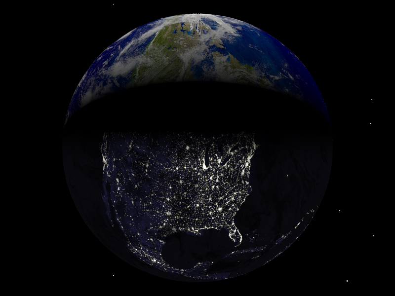
I tried this, but got strangely distorted bitmaps with sharp boundaries
between day and night texture (see attached image). Also, what was meant
to be a rendering centered around North Pole turned out to show mostly
North America...
Here is my code:
#declare sc=1000;
#declare bodies = array [81][12]
{
{ 0, 696000, -1, -1, 7.25, 0,
0, 0, 0, 0.000009, 63.87, 286.125 },
// 0 - Sun
{ 57909100, 2439.7, -1, -1, 2.11, 7.005,
0.205630, 29.124, 48.331, 0.00059, 61.45, 281.01 },
// 1 - Mercury
{ 108208930, 6051.8, -1, -1, 177.36, 3.39471,
0.0068, 54.85229, 76.67069, 0.00019, 67.16, 272.76 }, //
2 - Venus
{ 149597887.5, 6378.14, 6378.14, 6356.8, 23.439281, 0,
0.016710219, 114.20783, -1, 0.0033528, 90, 90 }
// 3 - Earth
[...]
}
#declare east=1;
#if (east)
#declare Pos_Earth = bodies[3][0]*<sin(radians(0)), 0,
cos(radians(0))>; // eastern hemisphere in daylight
#else
#declare Pos_Earth = bodies[3][0]*<sin(radians(180)), 0,
cos(radians(180))>; // western hemisphere in daylight
#end
#macro SetAxis(dec, ras)
rotate <bodies[3][4]-(90-dec), 0, 0>
rotate <0, 90-ras, 0>
#end
#declare T_Earth_Night =
texture
{
pigment
{
image_map
{
png "solarsys/ev5826_land_ocean_ice_lights_8192.png"
map_type 1
interpolate 2
}
// scale <1, 1, 0.5>
}
finish
{
ambient 1
diffuse 0
}
}
#declare T_Earth_Day =
texture
{
pigment
{
image_map
{
png "solarsys/ev11612_land_ocean_ice_8192_POV.png"
map_type 1
interpolate 2
}
// scale <1, 1, 0.5>
}
finish { F_Standard_Planetary_Surface }
}
union
{
sphere // Earth, surface
{
0, 1
texture
{
gradient z
texture_map
{
[0 T_Earth_Day]
[0.45 T_Earth_Day]
[0.55 T_Earth_Night]
[1 T_Earth_Night]
}
scale 2
translate <0, 0, -1>
}
scale <bodies[3][1], bodies[3][2], bodies[3][3]>/sc
}
sphere // Earth, clouds
{
0, 1
texture
{
pigment
{
image_map
{
png "solarsys/cloud_combined_8192a_alpha.png"
map_type 1
interpolate 2
}
}
finish { F_Standard_Planetary_Surface }
}
scale <bodies[3][1]+5, bodies[3][2]+5, bodies[3][3]+4.983270985>/sc
}
rotate -y*clock
SetAxis(bodies[3][10], bodies[3][11])
translate Pos_Earth/sc
}
#declare long =0;
#declare lat=90; // North Pole
#declare long=-long-90; // adjusting longitude to PoV-Ray's
rotation system
#declare h=20000; // orbital height (unscaled kilometres)
#declare camPos = Pos_Earth + vrotate ((6378.14 + h) *
<sin(radians(long))*cos(radians(lat)), sin(radians(lat)),
cos(radians(long))*cos(radians(lat))>, <bodies[3][4], 0, 0>);
#declare camLook = Pos_Earth;
#declare camAng = 40;
camera
{
#if (cam = 5.8)
sky camSky
#end
location camPos/sc
look_at camLook/sc
angle camAng
}
// end of code
See you in Khyberspace!
Yadgar
Post a reply to this message
Attachments:
Download 'povsolar.png' (305 KB)
Preview of image 'povsolar.png'
|
|