|
 |
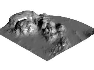
Christoph Hormann's recent updates on his LOTW-project, inspired me to do some
work on my own LOTW-system. Now, this is a technique-in-progress (TIP?). A
radial height_field. The idea is that parts of the landscape far away from the
camera don't need to be as detailed as the parts close to the camera. So in
terms of regular height_fields, the resolution may decrease as the distance from
the camera increases. This can easily be accomplished by going through the
points in your height_field-image (or function in this case) not in a
rectangular way, like regular height_fields, but in a radial way.
Hope you understand what I'm talking about :)
Oh, and, uhm, it might be an interesting technique, but I'm afraid, it's not
very useful: parse-time increases and trace-time doesn't really seem to be less
than an ordinary height_field :-/
cu!
--
camera{location-z*3}#macro G(b,e)b+(e-b)*(C/50)#end#macro L(b,e,k,l)#local C=0
;#while(C<50)sphere{G(b,e),.1pigment{rgb G(k,l)}finish{ambient 1}}#local C=C+1
;#end#end L(y-x,y,x,x+y)L(y,-x-y,x+y,y)L(-x-y,-y,y,y+z)L(-y,y,y+z,x+y)L(0,x+y,
<.5,1,.5>,x)L(0,x-y,<.5,1,.5>,x) // ZK http://www.povplace.com
Post a reply to this message
Attachments:
Download 'radialheightfield.jpg' (54 KB)
Preview of image 'radialheightfield.jpg'
|
|


