|
 |
"bob h" <omn### [at] charter net> wrote in message
news:3c305edc@news.povray.org...
---snip---
> where my Dad was born, Fairview, AL in a slave cabin on a old plantation
> in 1933 which is gone now.
---snip---
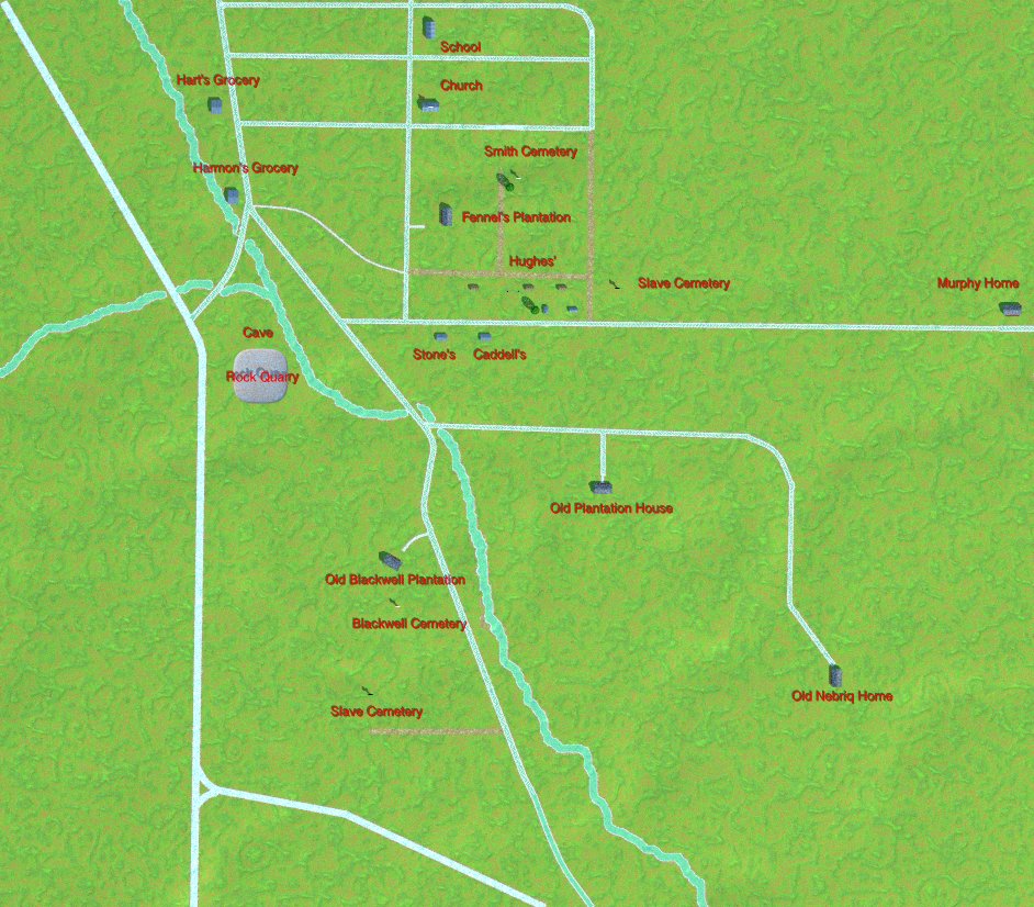
This is a map of the area I've put together in POV-Ray. Rudimentary but at
least shows the layout of the place. Could be difficult to see with high
resolution monitors.
The slave cabin my Dad was born in is that tiny rectangle below Hughes',
which happens to be in a line between two large oak trees; the only two oaks
I was told about and one still exists while the other is only remnants now.
Some pine trees are now there between the larger gap of the cabins where the
water well was, my Dad planted them and they are full grown trees now.
Speaking of things good ol' Dad did :-) he built a retaining wall behind
Harmon's grocery store (now gone due to a concrete waterway) and also built
a house further up on that street off this map a short ways.
It's a little odd maybe but that Blackwell plantation is now a country club
with golf course and the cemeteries are still there amid that. The other
slave cemetery is gone, only trees remain in the lawn of a house, street
goes through there too. The Smith cemetery is at the corner of a school,
the other school replaced by a fire department. The cave and rock quarry*
were built over too, my Dad swam in a pond formed there; those used to be
behind my Dad's oldest brother's house along the highway. I had been there
on a visit when I was a little kid and remember going into the cave and
seeing the pond. The roads were gravel and dirt back in the 1930's and in
the 1960's there still wasn't anything out there yet but the highway was
paved.
Not a thing of beauty raytrace-wise, just thought some of you might be
interested anyway. Probably more than anyone would care to know about. ;-)
Guess this would be better placed at my web space instead of here.
* possibly the quarry (outcropping of rock still there) used for making
columns for the Old State Bank building, a survivor of the Civil War
complete with bullet marks and is now a museum. We aren't sure because they
say a James Fennel lived on the other side of Decatur from the Fennel
plantation in my map. Only info concerning that is from
http://www.ohwy.com/al/o/olstbade.htm
Doesn't help any that fennel is a celery-like plant too. :-) Guess I could
always go find out at the Old State Bank.
bob h net> wrote in message
news:3c305edc@news.povray.org...
---snip---
> where my Dad was born, Fairview, AL in a slave cabin on a old plantation
> in 1933 which is gone now.
---snip---
This is a map of the area I've put together in POV-Ray. Rudimentary but at
least shows the layout of the place. Could be difficult to see with high
resolution monitors.
The slave cabin my Dad was born in is that tiny rectangle below Hughes',
which happens to be in a line between two large oak trees; the only two oaks
I was told about and one still exists while the other is only remnants now.
Some pine trees are now there between the larger gap of the cabins where the
water well was, my Dad planted them and they are full grown trees now.
Speaking of things good ol' Dad did :-) he built a retaining wall behind
Harmon's grocery store (now gone due to a concrete waterway) and also built
a house further up on that street off this map a short ways.
It's a little odd maybe but that Blackwell plantation is now a country club
with golf course and the cemeteries are still there amid that. The other
slave cemetery is gone, only trees remain in the lawn of a house, street
goes through there too. The Smith cemetery is at the corner of a school,
the other school replaced by a fire department. The cave and rock quarry*
were built over too, my Dad swam in a pond formed there; those used to be
behind my Dad's oldest brother's house along the highway. I had been there
on a visit when I was a little kid and remember going into the cave and
seeing the pond. The roads were gravel and dirt back in the 1930's and in
the 1960's there still wasn't anything out there yet but the highway was
paved.
Not a thing of beauty raytrace-wise, just thought some of you might be
interested anyway. Probably more than anyone would care to know about. ;-)
Guess this would be better placed at my web space instead of here.
* possibly the quarry (outcropping of rock still there) used for making
columns for the Old State Bank building, a survivor of the Civil War
complete with bullet marks and is now a museum. We aren't sure because they
say a James Fennel lived on the other side of Decatur from the Fennel
plantation in my map. Only info concerning that is from
http://www.ohwy.com/al/o/olstbade.htm
Doesn't help any that fennel is a celery-like plant too. :-) Guess I could
always go find out at the Old State Bank.
bob h
Post a reply to this message
Attachments:
Download 'fairview_oldmap.jpg' (182 KB)
Preview of image 'fairview_oldmap.jpg'
|
|