|
|
|
|
|
|
| |
| |
|
|
|
|
| |
| |
|
|
Thomas de Groot <tho### [at] degroot org> wrote:
> Overall, I think that version 4 is doing a good job and solves the
> problem of version 3. The attached image demonstrates that. Never mind
> the columns for supporting the sky ;-) Those are little troubles at the
> height_field's edges.
>
> --
> Thomas
Nice work, Thomas!
Would you be willing to share some of your eroded landscape height maps? org> wrote:
> Overall, I think that version 4 is doing a good job and solves the
> problem of version 3. The attached image demonstrates that. Never mind
> the columns for supporting the sky ;-) Those are little troubles at the
> height_field's edges.
>
> --
> Thomas
Nice work, Thomas!
Would you be willing to share some of your eroded landscape height maps?
Post a reply to this message
|
|
| |
| |
|
|
|
|
| |
| |
|
|
Thomas de Groot <tho### [at] degrootorg> wrote:
> On 22-2-2017 13:17, Thomas de Groot wrote:
> > This version does interesting things, different from the previous one.
Fascinating stuff, as I watch fervently from the sidelines.
Has me wondering if erosion could be accomplished via difference {} using
likewise cone+sphere stream/lake creation method.
Bob
Post a reply to this message
|
|
| |
| |
|
|
|
|
| |
| |
|
|
On 23-2-2017 22:04, omniverse wrote:
> Thomas de Groot <tho### [at] degrootorg> wrote:
>> On 22-2-2017 13:17, Thomas de Groot wrote:
>>> This version does interesting things, different from the previous one.
>
> Fascinating stuff, as I watch fervently from the sidelines.
>
> Has me wondering if erosion could be accomplished via difference {} using
> likewise cone+sphere stream/lake creation method.
>
You have had the same thought as I! This should not be too difficult to
do in principle. Something to explore...
--
Thomas
Post a reply to this message
|
|
| |
| |
|
|
|
|
| |
| |
|
|
Thomas de Groot <tho### [at] degrootorg> wrote:
> On 23-2-2017 22:04, omniverse wrote:
> > Thomas de Groot <tho### [at] degrootorg> wrote:
> >> On 22-2-2017 13:17, Thomas de Groot wrote:
> >>> This version does interesting things, different from the previous one.
> >
> > Fascinating stuff, as I watch fervently from the sidelines.
> >
> > Has me wondering if erosion could be accomplished via difference {} using
> > likewise cone+sphere stream/lake creation method.
> >
>
> You have had the same thought as I! This should not be too difficult to
> do in principle. Something to explore...
>
>
> --
> Thomas
Indeed I hope so, erosion really adds so much to a procedural landscape!
Post a reply to this message
|
|
| |
| |
|
|
|
|
| |
| |
|
|
"omniverse" <omn### [at] charternet> wrote:
> Thomas de Groot <tho### [at] degrootorg> wrote:
> > On 22-2-2017 13:17, Thomas de Groot wrote:
> > > This version does interesting things, different from the previous one.
>
> Fascinating stuff, as I watch fervently from the sidelines.
>
> Has me wondering if erosion could be accomplished via difference {} using
> likewise cone+sphere stream/lake creation method.
>
> Bob
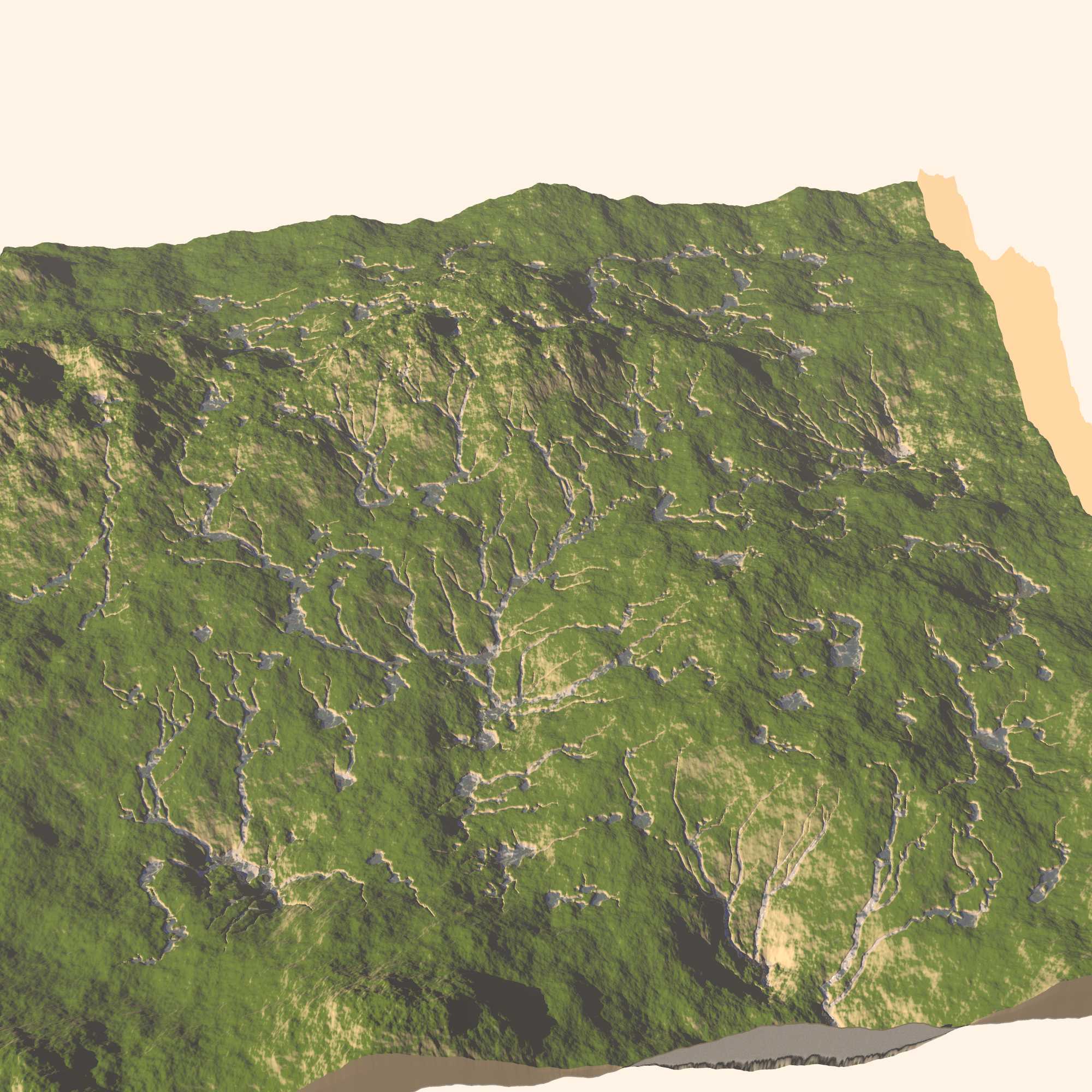
Looks like that was something I was trying out, back in 2008. Looks like I was
rendering out a flat image of just the rivers to be subtracted from the height
map image.
Post a reply to this message
Attachments:
Download 'together_rivers.jpg' (336 KB)
Preview of image 'together_rivers.jpg'
|
|
| |
| |
|
|
|
|
| |
| |
|
|
"Kirk Andrews" <kir### [at] tektonartcom> wrote:
> "omniverse" <omn### [at] charternet> wrote:
> >
> > Has me wondering if erosion could be accomplished via difference {} using
> > likewise cone+sphere stream/lake creation method.
>
> Looks like that was something I was trying out, back in 2008. Looks like I was
> rendering out a flat image of just the rivers to be subtracted from the height
> map image.
Sure does mess with my eyes! I turned it upside down, sideways too, and those
shadows just wouldn't get right for me.
Maybe I'm seeing it wrong but the tributaries appear to begin or end at the
lower elevations with pooling water at the higher elevations.
Does give the appearance of eroded ground anyhow regardless of how I see it.
Post a reply to this message
|
|
| |
| |
|
|
|
|
| |
| |
|
|
On 24-2-2017 15:28, Kirk Andrews wrote:
> "omniverse" <omn### [at] charternet> wrote:
>> Thomas de Groot <tho### [at] degrootorg> wrote:
>>> On 22-2-2017 13:17, Thomas de Groot wrote:
>>>> This version does interesting things, different from the previous one.
>>
>> Fascinating stuff, as I watch fervently from the sidelines.
>>
>> Has me wondering if erosion could be accomplished via difference {} using
>> likewise cone+sphere stream/lake creation method.
>>
>> Bob
>
> Looks like that was something I was trying out, back in 2008. Looks like I was
> rendering out a flat image of just the rivers to be subtracted from the height
> map image.
>
The water seems to be above the surface. Also, stream patterns do not
take the underlying landscape into account, with patterns happily
crossing peaks. I guess that the pattern was not derived from this
particular landscape but was just superposed on it for testing's sake.
Using a flow map generated from a particular landscape that would be
possible to do indeed. Wilbur, amongst others, can make such maps.
--
Thomas
Post a reply to this message
|
|
| |
| |
|
|
|
|
| |
| |
|
|
On 23-2-2017 16:12, Kirk Andrews wrote:
> Would you be willing to share some of your eroded landscape height maps?
>
They can be found now in p.b.misc. I had to convert them from tga to png
in order to reduce the size. But they work the same.
There was one example of a degenerate cylinder crashing the scene. Some
control on the hf margins seems to be necessary.
--
Thomas
Post a reply to this message
|
|
| |
| |
|
|
|
|
| |
| |
|
|
Am 25.02.2017 um 08:53 schrieb Thomas de Groot:
> The water seems to be above the surface. Also, stream patterns do not
> take the underlying landscape into account, with patterns happily
> crossing peaks. I guess that the pattern was not derived from this
> particular landscape but was just superposed on it for testing's sake.
> Using a flow map generated from a particular landscape that would be
> possible to do indeed. Wilbur, amongst others, can make such maps.
No, the image is ok. It's just surprisingly difficult to flip your brain
in the right direction, if you know what I mean.
Post a reply to this message
|
|
| |
| |
|
|
|
|
| |
| |
|
|
On 25-2-2017 10:29, clipka wrote:
> Am 25.02.2017 um 08:53 schrieb Thomas de Groot:
>
>> The water seems to be above the surface. Also, stream patterns do not
>> take the underlying landscape into account, with patterns happily
>> crossing peaks. I guess that the pattern was not derived from this
>> particular landscape but was just superposed on it for testing's sake.
>> Using a flow map generated from a particular landscape that would be
>> possible to do indeed. Wilbur, amongst others, can make such maps.
>
> No, the image is ok. It's just surprisingly difficult to flip your brain
> in the right direction, if you know what I mean.
>
I am not convinced. There is something absolutely wrong comparing the HF
shadows and the stream shadows. It would certainly help to convince me
if the camera view point was lower. ;-)
--
Thomas
Post a reply to this message
|
|
| |
| |
|
|
|
|
| |