|
|
|
|
|
|
| |
| |
|
|
|
|
| |
| |
|
|
On 16-2-2017 19:59, Kirk Andrews wrote:
> So, I'm starting to get my head around what's happening with the lakes not
> filling up. As it searches for a point lower than the water level in an
> increasing radius, it doesn't take into account whether or not the water can
> actually flow that way.
>
> So, for example, maybe the lake extends away to the north, beyond the current
> testing radius, and there is a ridge to south, but then a lower point. Since the
> lake extends away to the north, the algorithm detects that as the lowest point
> (equal to the current water level), and therefore does not raise the water
> level, but does keep expanding the radius. Eventually, it does detect a lower
> point, but it's on the other side of the ridge. Right now, the algorithm has no
> method to detect that the water can't get there from here, so it goes ahead and
> jumps the stream through the rock to the other side.
>
>
Ah. That is a complication indeed.
--
Thomas
Post a reply to this message
|
|
| |
| |
|
|
|
|
| |
| |
|
|
On 16-2-2017 19:59, Kirk Andrews wrote:
> So, I'm starting to get my head around what's happening with the lakes not
> filling up. As it searches for a point lower than the water level in an
> increasing radius, it doesn't take into account whether or not the water can
> actually flow that way.
>
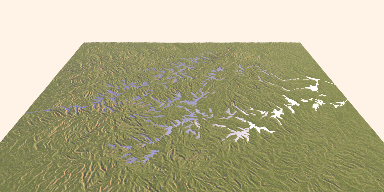
I used here a height_field where a drainage pattern has been eroded with
the help of a succession of different applications. As I expected, the
pattern is not perfect, with ridges barring the drainage courses in
several places. I have not yet found a single application that does the
job faultlessly.
However, the code does a good job I think in joining the lowermost areas.
--
Thomas
Post a reply to this message
Attachments:
Download 'ka_water3_test.png' (1066 KB)
Preview of image 'ka_water3_test.png'
|
|
| |
| |
|
|
|
|
| |
| |
|
|
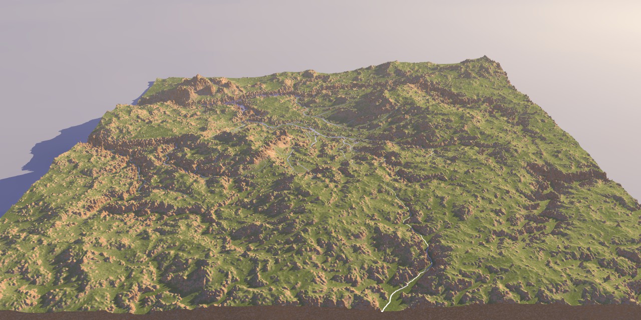
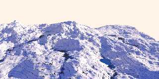
In this particular example, the erosional process seems to have been
better. A pity I cannot reproduce exactly what I did to get there as I
was just messing around without paying to close attention to the
different steps.
--
Thomas
Post a reply to this message
Attachments:
Download 'ka_water3_test.jpg' (230 KB)
Preview of image 'ka_water3_test.jpg'
|
|
| |
| |
|
|
|
|
| |
| |
|
|
Thomas de Groot <tho### [at] degroot org> wrote:
> In this particular example, the erosional process seems to have been
> better. A pity I cannot reproduce exactly what I did to get there as I
> was just messing around without paying to close attention to the
> different steps.
>
> --
> Thomas
That's looking really good, Thomas!
Which software are you using for erosion? Now that I don't have a PC anymore,
I've got to find something to run on my Mac. org> wrote:
> In this particular example, the erosional process seems to have been
> better. A pity I cannot reproduce exactly what I did to get there as I
> was just messing around without paying to close attention to the
> different steps.
>
> --
> Thomas
That's looking really good, Thomas!
Which software are you using for erosion? Now that I don't have a PC anymore,
I've got to find something to run on my Mac.
Post a reply to this message
|
|
| |
| |
|
|
|
|
| |
| |
|
|
On 2/17/2017 1:29 PM, Kirk Andrews wrote:
> Thomas de Groot <tho### [at] degrootorg> wrote:
>> In this particular example, the erosional process seems to have been
>> better. A pity I cannot reproduce exactly what I did to get there as I
>> was just messing around without paying to close attention to the
>> different steps.
>>
>> --
>> Thomas
>
> That's looking really good, Thomas!
>
It does indeed. :-)
> Which software are you using for erosion? Now that I don't have a PC anymore,
> I've got to find something to run on my Mac.
>
FYI
Thomas is a PC user.
I am trying to replicate it in Blender as a goal in learning to use
Blender. If I get anywhere I will post it here. But there is a lot to
learn, an awful lot. :)
--
Regards
Stephen
Post a reply to this message
|
|
| |
| |
|
|
|
|
| |
| |
|
|
Thomas de Groot <tho### [at] degrootorg> wrote:
> On 16-2-2017 19:59, Kirk Andrews wrote:
> > So, I'm starting to get my head around what's happening with the lakes not
> > filling up. As it searches for a point lower than the water level in an
> > increasing radius, it doesn't take into account whether or not the water can
> > actually flow that way.
> >
> > So, for example, maybe the lake extends away to the north, beyond the current
> > testing radius, and there is a ridge to south, but then a lower point. Since the
> > lake extends away to the north, the algorithm detects that as the lowest point
> > (equal to the current water level), and therefore does not raise the water
> > level, but does keep expanding the radius. Eventually, it does detect a lower
> > point, but it's on the other side of the ridge. Right now, the algorithm has no
> > method to detect that the water can't get there from here, so it goes ahead and
> > jumps the stream through the rock to the other side.
> >
> >
>
> Ah. That is a complication indeed.
>
> --
> Thomas
To do this *right*, I'm thinking you'd have to do a full-blown physics
simulation. But, I'm wondering if we can't get to a reasonable approximation
with some extra trace checks. Right now, it's only checking straight down from
above, but if we also checked across from the center point, maybe we could
eliminate points that didn't have a straight path from here to there. I
experimented with that idea some but I can't tell if it's really working yet.
https://www.dropbox.com/s/49nmnd5z1kzhms0/Water4.pov?dl=0
Post a reply to this message
Attachments:
Download 'water4.png' (1993 KB)
Preview of image 'water4.png'
|
|
| |
| |
|
|
|
|
| |
| |
|
|
Stephen <mca### [at] aolcom> wrote:
> > Which software are you using for erosion? Now that I don't have a PC anymore,
> > I've got to find something to run on my Mac.
> >
>
> FYI
> Thomas is a PC user.
>
Oh, I'm sure; but some of them are available on both platforms. I used to use
WorldMachine, but it's PC only.
Post a reply to this message
|
|
| |
| |
|
|
|
|
| |
| |
|
|
Not sure if this helps any - might be useful as a lead...
Busy at work, but couldn't help peeking
http://ncsu-geoforall-lab.github.io/geospatial-modeling-course/grass/simwe.html
http://www4.ncsu.edu/~hmitaso/gmslab/irwin/irwin1.html
https://www.google.com/webhp?sourceid=chrome-instant&ion=1&espv=2&ie=UTF-8#q=simwe+model
http://geoinfo.amu.edu.pl/sgp/LA/LA17/LA17_081-086.pdf
http://tucson.ars.ag.gov/isco/isco10/SustainingTheGlobalFarm/P081-Mitasova.pdf
Post a reply to this message
|
|
| |
| |
|
|
|
|
| |
| |
|
|
"Bald Eagle" <cre### [at] netscapenet> wrote:
> Not sure if this helps any - might be useful as a lead...
> Busy at work, but couldn't help peeking
>
> http://ncsu-geoforall-lab.github.io/geospatial-modeling-course/grass/simwe.html
>
> http://www4.ncsu.edu/~hmitaso/gmslab/irwin/irwin1.html
>
>
https://www.google.com/webhp?sourceid=chrome-instant&ion=1&espv=2&ie=UTF-8#q=simwe+model
>
> http://geoinfo.amu.edu.pl/sgp/LA/LA17/LA17_081-086.pdf
>
> http://tucson.ars.ag.gov/isco/isco10/SustainingTheGlobalFarm/P081-Mitasova.pdf
Oh man, looks like I've got reading to do.
Post a reply to this message
|
|
| |
| |
|
|
|
|
| |
| |
|
|
> To do this *right*, I'm thinking you'd have to do a full-blown physics
> simulation. But, I'm wondering if we can't get to a reasonable approximation
> with some extra trace checks. Right now, it's only checking straight down from
> above, but if we also checked across from the center point, maybe we could
> eliminate points that didn't have a straight path from here to there. I
> experimented with that idea some but I can't tell if it's really working yet.
>
Or, I suppose it could be as simple as what paint programs do with the fill
tool, and treat it more like square pixels.
Post a reply to this message
|
|
| |
| |
|
|
|
|
| |