|
|
|
|
|
|
| |
| |
|
|
|
|
| |
| |
|
|
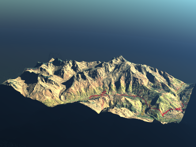
Hi there
this is a small test using a 30mx30m elevation grid on which I mapped the
corresponding roadmap. This is the Mont Blanc area (the winding road in red
above Chamonix is the one going to the tunnel entrance).
Maybe I'll try to add some small clouds later on...
Sylvain
Post a reply to this message
Attachments:
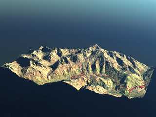
Download 'test_mont_blanc.png' (259 KB)
Preview of image 'test_mont_blanc.png'
|
|
| |
| |
|
|
|
|
| |
| |
|
|
Where's that mountain?
news:web.4492702be4ed7dda9e4a59f60@news.povray.org...
> Hi there
> this is a small test using a 30mx30m elevation grid on which I mapped the
> corresponding roadmap. This is the Mont Blanc area (the winding road in
> red
> above Chamonix is the one going to the tunnel entrance).
> Maybe I'll try to add some small clouds later on...
> Sylvain
>
Post a reply to this message
|
|
| |
| |
|
|
|
|
| |
| |
|
|
news: 4492ef94$1@news.povray.org...
> Where's that mountain?
>
in the Alps on the border between Italy and France
Marc
Post a reply to this message
Attachments:
Download 'Google Earth - Mont-Blanc.kmz.zip' (1 KB)
|
|
| |
| |
|
|
|
|
| |
| |
|
|
High!
M_a_r_c wrote:
> news: 4492ef94$1@news.povray.org...
>
>>Where's that mountain?
>>
>
> in the Alps on the border between Italy and France
Many people think it's the highest mountain of Europe (4807 m), but
recently there's a trend to accept Mt. Elbrus (5633 m) in the Russian
Caucasus as "top of Europe"!
See you in Khyberspace - I'll have much higher mountains there, such as
Mt. Noshaq (7450 m) and Koh-e Bandakor (6843 m)!
Yadgar
Now playing: I just want to let you know (The Communards)
Post a reply to this message
|
|
| |
| |
|
|
|
|
| |
| |
|
|
In article <web.4492702be4ed7dda9e4a59f60@news.povray.org>,
"Sylvain" <rem### [at] laposte net> wrote:
> Hi there
> this is a small test using a 30mx30m elevation grid on which I mapped the
> corresponding roadmap. This is the Mont Blanc area (the winding road in red
> above Chamonix is the one going to the tunnel entrance).
> Maybe I'll try to add some small clouds later on...
> Sylvain
> ---------------------------------------------------------------------
> [Image]
good test ! but, where do you find this kind of maps ?
--
klp net> wrote:
> Hi there
> this is a small test using a 30mx30m elevation grid on which I mapped the
> corresponding roadmap. This is the Mont Blanc area (the winding road in red
> above Chamonix is the one going to the tunnel entrance).
> Maybe I'll try to add some small clouds later on...
> Sylvain
> ---------------------------------------------------------------------
> [Image]
good test ! but, where do you find this kind of maps ?
--
klp
Post a reply to this message
|
|
| |
| |
|
|
|
|
| |
| |
|
|
"Sylvain" <rem### [at] lapostenet> wrote:
> Hi there
> this is a small test using a 30mx30m elevation grid on which I mapped the
> corresponding roadmap. This is the Mont Blanc area (the winding road in red
> above Chamonix is the one going to the tunnel entrance).
> Maybe I'll try to add some small clouds later on...
> Sylvain
Hi, nice stuff.
Some time ago, I tried to render DEM files with povray, but there are lots
of differents types of DEM files.
What type did you use, what converter, where did you find the DEM where the
maps?
Cheers,
Fabien
Post a reply to this message
|
|
| |
| |
|
|
|
|
| |
| |
|
|
"HENON fabien" <fab### [at] caramailcom> wrote:
> "Sylvain" <rem### [at] lapostenet> wrote:
> > Hi there
> > this is a small test using a 30mx30m elevation grid on which I mapped the
> > corresponding roadmap. This is the Mont Blanc area (the winding road in red
> > above Chamonix is the one going to the tunnel entrance).
> > Maybe I'll try to add some small clouds later on...
> > Sylvain
>
> Hi, nice stuff.
>
> Some time ago, I tried to render DEM files with povray, but there are lots
> of differents types of DEM files.
> What type did you use, what converter, where did you find the DEM where the
> maps?
>
> Cheers,
>
> Fabien
I got the data from somewhere on the net (can't remember where though). A
great resource for elevation data is the Nasa SRTM data (google for SRTM or
go to : ftp://e0srp01u.ecs.nasa.gov/)
Once you've obtained the file containing the elevations (a n x m matrix,
each of the element being an altitude), edit it in a text editor. As the
file is in binary format, you'll see tons of silly characters. Just add at
the begining of the file the following lines :
P5
1201 1201
65535
and save the file with extension ".pgm". You'll then have a picture that you
can use with POV. 1201 1201 is the size of the matrix, so adapt it to your
data. 65535 is the max value.
See also :
http://www.imagico.de/pov/earth_scene.html
and
http://news.povray.org/povray.general/thread/%3Ce5n9e0%24dn6%241%40chho.imagico.de%3E/
where I asked about the same question and Christoph kindly gave his reply.
I hope this has been helpful...
S.
Post a reply to this message
|
|
| |
| |
|
|
|
|
| |
| |
|
|
Hi Sylvain, thanks for all the information. I'll try that now.
Merci et a+
Fabien
"Sylvain" <rem### [at] lapostenet> wrote:
> "HENON fabien" <fab### [at] caramailcom> wrote:
> > "Sylvain" <rem### [at] lapostenet> wrote:
> > > Hi there
> > > this is a small test using a 30mx30m elevation grid on which I mapped the
> > > corresponding roadmap. This is the Mont Blanc area (the winding road in red
> > > above Chamonix is the one going to the tunnel entrance).
> > > Maybe I'll try to add some small clouds later on...
> > > Sylvain
> >
> > Hi, nice stuff.
> >
> > Some time ago, I tried to render DEM files with povray, but there are lots
> > of differents types of DEM files.
> > What type did you use, what converter, where did you find the DEM where the
> > maps?
> >
> > Cheers,
> >
> > Fabien
>
> I got the data from somewhere on the net (can't remember where though). A
> great resource for elevation data is the Nasa SRTM data (google for SRTM or
> go to : ftp://e0srp01u.ecs.nasa.gov/)
>
> Once you've obtained the file containing the elevations (a n x m matrix,
> each of the element being an altitude), edit it in a text editor. As the
> file is in binary format, you'll see tons of silly characters. Just add at
> the begining of the file the following lines :
> P5
> 1201 1201
> 65535
> and save the file with extension ".pgm". You'll then have a picture that you
> can use with POV. 1201 1201 is the size of the matrix, so adapt it to your
> data. 65535 is the max value.
> See also :
> http://www.imagico.de/pov/earth_scene.html
> and
>
http://news.povray.org/povray.general/thread/%3Ce5n9e0%24dn6%241%40chho.imagico.de%3E/
> where I asked about the same question and Christoph kindly gave his reply.
>
> I hope this has been helpful...
>
> S.
Post a reply to this message
|
|
| |
| |
|
|
|
|
| |
| |
|
|
A new interesting way to use our time....
;-)
Paolo
> "Sylvain" <rem### [at] lapostenet> wrote:
>
> I got the data from somewhere on the net (can't remember where though). A
> great resource for elevation data is the Nasa SRTM data (google for SRTM
or
> go to : ftp://e0srp01u.ecs.nasa.gov/)
>
> Once you've obtained the file containing the elevations (a n x m matrix,
> each of the element being an altitude), edit it in a text editor. As the
> file is in binary format, you'll see tons of silly characters. Just add at
> the begining of the file the following lines :
> P5
> 1201 1201
> 65535
> and save the file with extension ".pgm". You'll then have a picture that
you
> can use with POV. 1201 1201 is the size of the matrix, so adapt it to your
> data. 65535 is the max value.
> See also :
> http://www.imagico.de/pov/earth_scene.html
> and
>
http://news.povray.org/povray.general/thread/%3Ce5n9e0%24dn6%241%40chho.imagico.de%3E/
> where I asked about the same question and Christoph kindly gave his reply.
>
> I hope this has been helpful...
>
> S.
>
>
Post a reply to this message
|
|
| |
| |
|
|
|
|
| |
| |
|
|
Hi again,
Thank you very much for the comments.
Cool render Sylvain!
Regards,
Oleguer
> High!
>
> M_a_r_c wrote:
>> news: 4492ef94$1@news.povray.org...
>>
>>> Where's that mountain?
>>>
>>
>> in the Alps on the border between Italy and France
>
> Many people think it's the highest mountain of Europe (4807 m), but
> recently there's a trend to accept Mt. Elbrus (5633 m) in the Russian
> Caucasus as "top of Europe"!
>
> See you in Khyberspace - I'll have much higher mountains there, such as
> Mt. Noshaq (7450 m) and Koh-e Bandakor (6843 m)!
>
> Yadgar
>
> Now playing: I just want to let you know (The Communards)
Post a reply to this message
|
|
| |
| |
|
|
|
|
| |