|
|
|
|
|
|
| |
| |
|
|
|
|
| |
| |
|
|
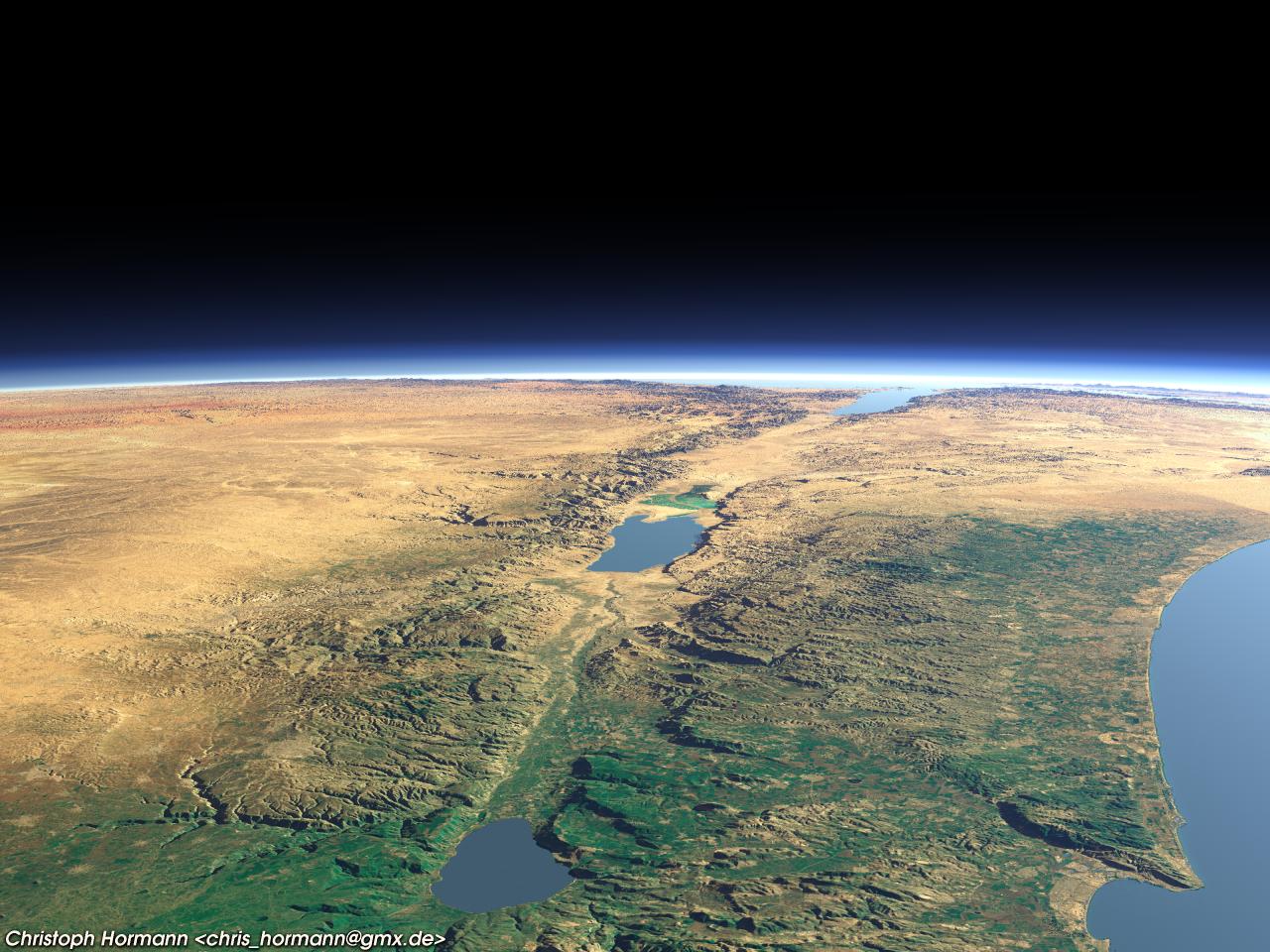
Since the last ones were quite popular here is another from a different
region (guess where).
Because the server for the landsat images used previously
(onearth.jpl.nasa.gov) is no more open to the public i had to go the
hard way and process the original landsat scenes (you can get them from
http://glcf.umiacs.umd.edu/) but that's always quite a large download
(about 1GB for this image).
Also using bicubic interpolation for the height data now - thanks to
Lutz-Peter, see:
Subject: bicubic interpolation patch, rev.2 - bicubic_interp_src.zip [1/1]
Date: Wed, 11 Jun 2003 17:47:12 +0200
From: Lutz-Peter Hooge <lpv### [at] gmx de>
Newsgroups: povray.binaries.programming
Christoph
--
POV-Ray tutorials, include files, Sim-POV,
HCR-Edit and more: http://www.tu-bs.de/~y0013390/
Last updated 23 Sep. 2004 _____./\/^>_*_<^\/\.______ de>
Newsgroups: povray.binaries.programming
Christoph
--
POV-Ray tutorials, include files, Sim-POV,
HCR-Edit and more: http://www.tu-bs.de/~y0013390/
Last updated 23 Sep. 2004 _____./\/^>_*_<^\/\.______
Post a reply to this message
Attachments:
Download 'earth_jordan3.jpg' (196 KB)
Preview of image 'earth_jordan3.jpg'
|
|
| |
| |
|
|
|
|
| |
| |
|
|
Christoph Hormann schrieb:
> Since the last ones were quite popular here is another from a different
> region (guess where).
> filename="earth_jordan3.jpg"
You are joking. Right? ;-)
http://www.lib.utexas.edu/maps/middle_east_and_asia/israel.gif
Great Image
--
mat### [at] matweide
http://www.matwei.de
Post a reply to this message
|
|
| |
| |
|
|
|
|
| |
| |
|
|
Mark Shuttleworth <chr### [at] gmxde> wrote:
> guess where
Hmm, too much sand for http://www.only-maps.com/quebec-map.jpg .
How was the flight?
ABX
Post a reply to this message
|
|
| |
| |
|
|
|
|
| |
| |
|
|
Hey, groovy!
The water looks wrong - but the rest is great.
Post a reply to this message
|
|
| |
| |
|
|
|
|
| |
| |
|
|
High!
Awesome like always... reminds me of a similar Israel/Palestine
rendering published in GEO magazine some three years ago!
I assume you used the 3-arcsecond elevation data from USGS... how did
you get rid of the data gaps? Did you use 3DEM's interpolation function
or printed topographic maps to fill in?
See you in Khyberspace!
Yadgar
Now playing: Spring (Walter Carlos)
Post a reply to this message
|
|
| |
| |
|
|
|
|
| |
| |
|
|
Yadgar wrote:
>
> I assume you used the 3-arcsecond elevation data from USGS... how did
> you get rid of the data gaps?
Gaps are rarely a problem outside high mountain regions. The lack of
underwater relief and non-constant sea level values (they vary more than
+/- 10 meter) is much more critical.
Thanks to everyone for the comments.
Christoph
--
POV-Ray tutorials, include files, Sim-POV,
HCR-Edit and more: http://www.tu-bs.de/~y0013390/
Last updated 23 Sep. 2004 _____./\/^>_*_<^\/\.______
Post a reply to this message
|
|
| |
| |
|
|
|
|
| |
| |
|
|
Really excellent render!!
Like you say, bathymetric data is missing, unfortunately. I have been
looking everywhere for that, but it is not readily available on the net, it
seems, except for some more or less detailed maps. In any case, bathymetry
for coastal regions would then still be a problem, at least till about the
20m depth contour, as ships rarily go there for measurements. However, there
must be satellite data somewhere. Not made public for strategic reasons? I
wonder.
Thomas
Post a reply to this message
|
|
| |
| |
|
|
|
|
| |
| |
|
|
Thomas de Groot wrote:
> Really excellent render!!
> Like you say, bathymetric data is missing, unfortunately. I have been
> looking everywhere for that, but it is not readily available on the net, it
> seems, except for some more or less detailed maps. In any case, bathymetry
> for coastal regions would then still be a problem, at least till about the
> 20m depth contour, as ships rarily go there for measurements. However, there
> must be satellite data somewhere. Not made public for strategic reasons? I
> wonder.
There exists no accurate underwater relief information (and i am not
aware of any reliable method to determine water depth from space) but
that's also not the problem. The problem is to determine the exact
waterline - in many regions the height difference on the land near the
coast is similar to the noise on the water (i.e. a few meters). You can
of course see the water line on satellite images but using this to
modify the height map requires a lot of hand work.
Christoph
--
POV-Ray tutorials, include files, Sim-POV,
HCR-Edit and more: http://www.tu-bs.de/~y0013390/
Last updated 23 Sep. 2004 _____./\/^>_*_<^\/\.______
Post a reply to this message
|
|
| |
| |
|
|
|
|
| |