|
|
|
|
|
|
| |
| |
|
|
|
|
| |
| |
|
|
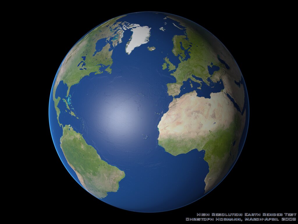
At the first glance this probably looks like yet another boring earth
image but it is somewhat different.

I used the 1km resolution data sets for geometry and coloring available
on:

http://earthobservatory.nasa.gov/Newsroom/BlueMarble/

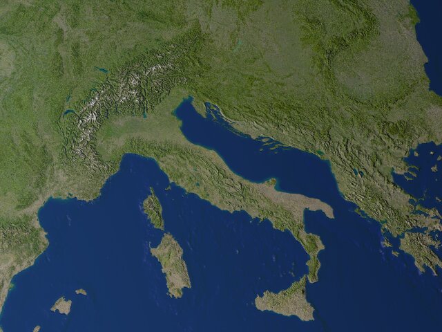
and used real surface geometry instead of bump mapping.  Of course the
detail is hardly visible at this size, the second image shows a sample
from the original render at 6400x4800 pixel size.

It was of course not possible to render the whole planet in one piece, the
height data alone is about 2GB.  Therefore i split it into 45x45 degree
tiles and rendered them one after the other (with some overlap).

Files with cloud coverage data are available at the mentioned site too but
with strongly varying quality.  A short distance view with clouds of parts
of europe (with 2.5x exaggerated height) can be seen on:

http://www.schunter.etc.tu-bs.de/~chris/files/earth_a2.jpg

the same without clouds on:

http://www.schunter.etc.tu-bs.de/~chris/files/earth_a1.jpg

I searched a lot for cloud height data which would be important for
realistic clouds but i could not find anything useful.

I also made a view with natural height scale of western himalayas and
karakorum:

http://www.schunter.etc.tu-bs.de/~chris/files/earth_a3l.jpg

this shows the available detail level in the data and also the varying
quality in some parts (note the broad band of lower quality on the right).

Christoph

--
POV-Ray tutorials, include files, Sim-POV,
HCR-Edit and more: http://www.tu-bs.de/~y0013390/
Last updated 28 Feb. 2003 _____./\/^>_*_<^\/\.______
Post a reply to this message
Attachments:
Download 'earth_l.jpg' (71 KB)
Download 'earth_l_detail.jpg' (68 KB)
Preview of image 'earth_l.jpg'
Preview of image 'earth_l_detail.jpg'
|
|
| |
| |
|
|
|
|
| |
| |
|
|
Hmm, two things I noticed:

1. The ocean is bumpy. Did you mean to show the bumps underneath the ocean
as though they're just blue terrain?

2. The atmosphere on the dark side of the earth is lit - scattering media
would have helped here =)

In fact, that whole part of the earth really should be 99% black.

 - Slime
[ http://www.slimeland.com/ ]
Post a reply to this message
|
|
| |
| |
|
|
From: Christoph Hormann
Subject: Re: rendering the earth (71k+68k)
Date: 1 Apr 2003 16:45:00
Message: <3E8A085C.27A34F@gmx.de>
|
|
|
| |
| |
|
|
Slime wrote:
>
> Hmm, two things I noticed:
>
> 1. The ocean is bumpy. Did you mean to show the bumps underneath the ocean
> as though they're just blue terrain?
>
> 2. The atmosphere on the dark side of the earth is lit - scattering media
> would have helped here =)
>
> In fact, that whole part of the earth really should be 99% black.

To answer all the questions at once - i was not striving for realism
here.  The dark side does not necessarily has to be completely dark
(moonlight for example) but quite a bit darker would be more realistic of
course.  Scattering media would be overkill since you can simply use
different media for light and dark side.

The bumps in the ocean are ocean floor structures.  I also tried a
completely opaque water surface but i liked this version more.

Christoph

--
POV-Ray tutorials, include files, Sim-POV,
HCR-Edit and more: http://www.tu-bs.de/~y0013390/
Last updated 28 Feb. 2003 _____./\/^>_*_<^\/\.______
Post a reply to this message
|
|
| |
| |
|
|
|
|
| |
| |
|
|
Christoph Hormann wrote:
>I used the 1km resolution data sets for geometry and coloring available
>on:
>
>http://earthobservatory.nasa.gov/Newsroom/BlueMarble/
>
>and used real surface geometry instead of bump mapping.  Of course the
>detail is hardly visible at this size, the second image shows a sample
>from the original render at 6400x4800 pixel size.

Wow, those are impressive images! I've never seen an image such as your
Himalaya image, where you can see the curvature of the earth and the
non-smoothness of the surface (mountains). It would make a great backdrop
for an animation. I like the atmosphere also.

How was the earth's surface modeled, as a triangle mesh or some other
method?

Another way to show the depths of the seas would be to color-code a smooth
surface (deeper waters darker blue).

How long did it take to render? I've always been impressed with how fast
POV-Ray can render huge files. I was able to render an image (Space Station
Node 2) from 700MB of triangles in about five minutes.
Post a reply to this message
|
|
| |
| |
|
|
|
|
| |
| |
|
|
Christoph Hormann <chr### [at] gmx de> escribió en el mensaje de noticias
3E89FD53.12F835E6@gmx.de...
> snip
Wow!, these are really impressive images, and
very beautiful.
A lot of time and work invested here, but with
a great result.
> A short distance view with clouds of parts
> of europe (with 2.5x exaggerated height) can be seen on:
>
> http://www.schunter.etc.tu-bs.de/~chris/files/earth_a2.jpg
> the same without clouds on:
>
> http://www.schunter.etc.tu-bs.de/~chris/files/earth_a1.jpg
Hey, I can see my house in those...:-)
> I also made a view with natural height scale of western himalayas and
> karakorum:
>
> http://www.schunter.etc.tu-bs.de/~chris/files/earth_a3l.jpg
Wow, Wow, Wow. Really great.
I've saved all the files in my HD.
Thank you very much for sharing them.
Yours Sincerely.
Txemi Jendrix
http://www.txemijendrix.com de> escribió en el mensaje de noticias
3E89FD53.12F835E6@gmx.de...
> snip
Wow!, these are really impressive images, and
very beautiful.
A lot of time and work invested here, but with
a great result.
> A short distance view with clouds of parts
> of europe (with 2.5x exaggerated height) can be seen on:
>
> http://www.schunter.etc.tu-bs.de/~chris/files/earth_a2.jpg
> the same without clouds on:
>
> http://www.schunter.etc.tu-bs.de/~chris/files/earth_a1.jpg
Hey, I can see my house in those...:-)
> I also made a view with natural height scale of western himalayas and
> karakorum:
>
> http://www.schunter.etc.tu-bs.de/~chris/files/earth_a3l.jpg
Wow, Wow, Wow. Really great.
I've saved all the files in my HD.
Thank you very much for sharing them.
Yours Sincerely.
Txemi Jendrix
http://www.txemijendrix.com
Post a reply to this message
|
|
| |
| |
|
|
|
|
| |
| |
|
|
Those are delicious! I am tempted to make some quip about taking
landscape tracing to new heights, but I'll spare you.

-Jim
Post a reply to this message
|
|
| |
| |
|
|
|
|
| |
| |
|
|
> Scattering media would be overkill since you can simply use
> different media for light and dark side.


Wellll...... it would be ever so slightly different =)

(really, only right near the shadow line)

 - Slime
[ http://www.slimeland.com/ ]
Post a reply to this message
|
|
| |
| |
|
|
|
|
| |
| |
|
|
Slime wrote:
> Wellll...... it would be ever so slightly different =)
> (really, only right near the shadow line)

That's what gradients are for.

--
Tim Cook
http://home.bellsouth.net/p/PWP-empyrean

-----BEGIN GEEK CODE BLOCK-----
Version: 3.12
GFA dpu- s: a?-- C++(++++) U P? L E--- W++(+++)>$
N++ o? K- w(+) O? M-(--) V? PS+(+++) PE(--) Y(--)
PGP-(--) t* 5++>+++++ X+ R* tv+ b++(+++) DI
D++(---) G(++) e*>++ h+ !r--- !y--
------END GEEK CODE BLOCK------
Post a reply to this message
|
|
| |
| |
|
|
|
|
| |
| |
|
|
> That's what gradients are for.


That's not what I was referring to. The shadow of the earth would blacken
out the shadowed side, except for the part of the media that stuck out right
above the shadow line. So right on the edges there, there would be parts
illuminated that wouldn't be if the media were split completely in half.
It's hard to describe exactly what I'm talking about.

Of course, if you really want to be picky, there's also the issue of
scattering media self-shadowing, which would be extremely hard to model 100%
correctly without scattering media =)

But I was just trying to get your goat; I'm not really interested in
defending this =)

 - Slime
[ http://www.slimeland.com/ ]
Post a reply to this message
|
|
| |
| |
|
|
|
|
| |
| |
|
|
Where are the icey northpole?
Not to mention, the southpole?

Nice render, anyway.

Regards,
Hugo
Post a reply to this message
|
|
| |
| |
|
|
|
|
| |
| |
|
|
Renderdog wrote:
>
> Wow, those are impressive images! I've never seen an image such as your
> Himalaya image, where you can see the curvature of the earth and the
> non-smoothness of the surface (mountains). It would make a great backdrop
> for an animation. I like the atmosphere also.

Thanks.

> How was the earth's surface modeled, as a triangle mesh or some other
> method?

A mesh would have taken way too much memory.  Remember the whole earth
with 1km resolution in a regular lat/lon mesh would mean about 1.8 billion
triangles.  A 45x45 degree tile still has 29 million vertices which (with
normal vectors) would use about 700 Mb (not counting the face and normal
indices!)

I used an isosurface with an image_map pigment function defining the
height of the terrain.  This only uses 2 byte per pixel and nothing more
(about 56 Mb per tile for the height data).

> Another way to show the depths of the seas would be to color-code a smooth
> surface (deeper waters darker blue).

I have also made test with color depending on the height and without the
image_map texture.  Will see if i can post some sample for that too.

> How long did it take to render? I've always been impressed with how fast
> POV-Ray can render huge files.

The whole image at 6400x4800 took about 1-2 days.  The speed of rendering
an isosurface does not much depend on the detail level (although more
detailed data of course requires higher max_gradient).

Christoph

--
POV-Ray tutorials, include files, Sim-POV,
HCR-Edit and more: http://www.tu-bs.de/~y0013390/
Last updated 28 Feb. 2003 _____./\/^>_*_<^\/\.______
Post a reply to this message
|
|
| |
| |
|
|
|
|
| |
| |
|
|
Hugo Asm wrote:
>
> Where are the icey northpole?
> Not to mention, the southpole?
>

The south pole is not visible. :-)  There is data for the polar ice cover
but i did not try to add it yet.

Christoph

--
POV-Ray tutorials, include files, Sim-POV,
HCR-Edit and more: http://www.tu-bs.de/~y0013390/
Last updated 28 Feb. 2003 _____./\/^>_*_<^\/\.______
Post a reply to this message
|
|
| |
| |
|
|
|
|
| |
| |
|
|
Hi!

this is ages after you posted this, but i was wondering if i could use your
picture of the earth and use it for my own personal use?

Thanks a lot!!!


Christoph Hormann <chr### [at] gmxde> wrote:
> At the first glance this probably looks like yet another boring earth
> image but it is somewhat different.
>
> I used the 1km resolution data sets for geometry and coloring available
> on:
>
> http://earthobservatory.nasa.gov/Newsroom/BlueMarble/
>
> and used real surface geometry instead of bump mapping.  Of course the
> detail is hardly visible at this size, the second image shows a sample
> from the original render at 6400x4800 pixel size.
>
> It was of course not possible to render the whole planet in one piece, the
> height data alone is about 2GB.  Therefore i split it into 45x45 degree
> tiles and rendered them one after the other (with some overlap).
>
> Files with cloud coverage data are available at the mentioned site too but
> with strongly varying quality.  A short distance view with clouds of parts
> of europe (with 2.5x exaggerated height) can be seen on:
>
> http://www.schunter.etc.tu-bs.de/~chris/files/earth_a2.jpg
>
> the same without clouds on:
>
> http://www.schunter.etc.tu-bs.de/~chris/files/earth_a1.jpg
>
> I searched a lot for cloud height data which would be important for
> realistic clouds but i could not find anything useful.
>
> I also made a view with natural height scale of western himalayas and
> karakorum:
>
> http://www.schunter.etc.tu-bs.de/~chris/files/earth_a3l.jpg
>
> this shows the available detail level in the data and also the varying
> quality in some parts (note the broad band of lower quality on the right).
>
> Christoph
>
> --
> POV-Ray tutorials, include files, Sim-POV,
> HCR-Edit and more: http://www.tu-bs.de/~y0013390/
> Last updated 28 Feb. 2003 _____.//^>_*_<^/.______
Post a reply to this message
|
|
| |
| |
|
|
|
|
| |
| |
|
|
See the following:

http://www.wikipov.org/ow.asp?EarthModel


Neil

"cedriccrucke" <ced### [at] hotmailcom> wrote in message
news:web.41fa53c2bf3d391c20b6508a0@news.povray.org...
> Hi!
>
> this is ages after you posted this, but i was wondering if i could use
> your
> picture of the earth and use it for my own personal use?
>
> Thanks a lot!!!
>
>
>
>
>
>
>
>
>
>
>
>
>
>
>
> Christoph Hormann <chr### [at] gmxde> wrote:
>> At the first glance this probably looks like yet another boring earth
>> image but it is somewhat different.
>>
>> I used the 1km resolution data sets for geometry and coloring available
>> on:
>>
>> http://earthobservatory.nasa.gov/Newsroom/BlueMarble/
>>
>> and used real surface geometry instead of bump mapping.  Of course the
>> detail is hardly visible at this size, the second image shows a sample
>> from the original render at 6400x4800 pixel size.
>>
>> It was of course not possible to render the whole planet in one piece,
>> the
>> height data alone is about 2GB.  Therefore i split it into 45x45 degree
>> tiles and rendered them one after the other (with some overlap).
>>
>> Files with cloud coverage data are available at the mentioned site too
>> but
>> with strongly varying quality.  A short distance view with clouds of
>> parts
>> of europe (with 2.5x exaggerated height) can be seen on:
>>
>> http://www.schunter.etc.tu-bs.de/~chris/files/earth_a2.jpg
>>
>> the same without clouds on:
>>
>> http://www.schunter.etc.tu-bs.de/~chris/files/earth_a1.jpg
>>
>> I searched a lot for cloud height data which would be important for
>> realistic clouds but i could not find anything useful.
>>
>> I also made a view with natural height scale of western himalayas and
>> karakorum:
>>
>> http://www.schunter.etc.tu-bs.de/~chris/files/earth_a3l.jpg
>>
>> this shows the available detail level in the data and also the varying
>> quality in some parts (note the broad band of lower quality on the
>> right).
>>
>> Christoph
>>
>> --
>> POV-Ray tutorials, include files, Sim-POV,
>> HCR-Edit and more: http://www.tu-bs.de/~y0013390/
>> Last updated 28 Feb. 2003 _____.//^>_*_<^/.______
>
>
>
Post a reply to this message
|
|
| |
| |
|
|
|
|
| |