|
|
|
|
|
|
| |
| |
|
|
From: Timothy R Cook
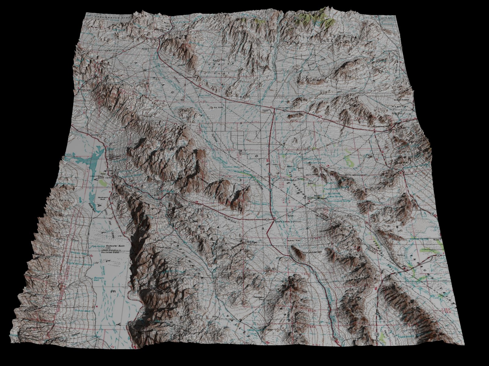
Subject: DEM with topo overlay (1600x1200; 509 k)
Date: 20 Feb 2003 03:23:57
Message: <3e54909d@news.povray.org>
|
|
|
| |
| |
|
|
oddly, the topographic map doesn't match up with the
DEM and has to be extensively compensated for distortion
...I got somewhat close, but not 100%
--
--Tim Cook
http://home.bellsouth.net/p/PWP-empyrean
-----BEGIN GEEK CODE BLOCK-----
Version: 3.12
GFA dpu- s: a?-- C++(++++) U P? L E--- W++(+++)>$
N++ o? K- w(+) O? M-(--) V? PS+(+++) PE(--) Y(--)
PGP-(--) t* 5++>+++++ X+ R* tv+ b++(+++) DI
D++(---) G(++) e*>++ h+ !r--- !y--
------END GEEK CODE BLOCK------
Post a reply to this message
Attachments:
Download 'dem.jpg' (509 KB)
Preview of image 'dem.jpg'
|
|
| |
| |
|
|
From: Nathan Letwory
Subject: Re: DEM with topo overlay (1600x1200; 509 k)
Date: 20 Feb 2003 04:55:28
Message: <3e54a610@news.povray.org>
|
|
|
| |
| |
|
|
Timothy R. Cook wrote:
> oddly, the topographic map doesn't match up with the
> DEM and has to be extensively compensated for distortion
> ...I got somewhat close, but not 100%
>
>
> ------------------------------------------------------------------------
>
Hei, cool. Well, most people probably won't notice the errors ;)
-Nathan
Post a reply to this message
|
|
| |
| |
|
|
From: Thomas Willhalm
Subject: Re: DEM with topo overlay (1600x1200; 509 k)
Date: 20 Feb 2003 07:09:01
Message: <3e54c55d@news.povray.org>
|
|
|
| |
| |
|
|
"Timothy R. Cook" <z993126bellsouth.net> wrote:
Nice idea!
> oddly, the topographic map doesn't match up with the
> DEM and has to be extensively compensated for distortion
> ...I got somewhat close, but not 100%
I wouldn't car about the errors too much. It already looks good as it is.
Thomas
Post a reply to this message
|
|
| |
| |
|
|
|
|
| |
| |
|
|
Tim,
Perhaps not so odd. I vaguely remember something about topo data being projected
onto a plane and DEM data following the curve of the earth. There are also a
couple of standards for representation of DEM data which differ. Maybe someone
who really knows will enlighten us.
Regards, Bill P.
>
> oddly, the topographic map doesn't match up with the
> DEM and has to be extensively compensated for distortion
Post a reply to this message
|
|
| |
| |
|
|
From: Timothy R Cook
Subject: Re: DEM with topo overlay (1600x1200; 509 k)
Date: 20 Feb 2003 12:01:01
Message: <3e5509cd@news.povray.org>
|
|
|
| |
| |
|
|
Thomas Willhalm wrote:
> I wouldn't car about the errors too much. It already looks good as it is.
Well...it is I think better than 99.9% match...but a DEM from the USGS
site and a topographic map made by the USGS ought to match up exactly.
Took me a while to assemble the topo from terraserver.com :P
doubtful I'll be doing the whole continental US like that...DEMs are
easy to do tho.
--
--Tim Cook
http://home.bellsouth.net/p/PWP-empyrean
-----BEGIN GEEK CODE BLOCK-----
Version: 3.12
GFA dpu- s: a?-- C++(++++) U P? L E--- W++(+++)>$
N++ o? K- w(+) O? M-(--) V? PS+(+++) PE(--) Y(--)
PGP-(--) t* 5++>+++++ X+ R* tv+ b++(+++) DI
D++(---) G(++) e*>++ h+ !r--- !y--
------END GEEK CODE BLOCK------
Post a reply to this message
|
|
| |
| |
|
|
From: Timothy R Cook
Subject: Re: DEM with topo overlay (1600x1200; 509 k)
Date: 20 Feb 2003 12:04:10
Message: <3e550a8a@news.povray.org>
|
|
|
| |
| |
|
|
William F. Pokorny wrote:
> Perhaps not so odd. I vaguely remember something about topo data being projected
> onto a plane and DEM data following the curve of the earth. There are also a
> couple of standards for representation of DEM data which differ. Maybe someone
> who really knows will enlighten us.
That could be it...the topo map is, at the very least, significantly
taller than the matching DEM data...and once stretched to fit, there's
some minor distortions...at the Death Valley lattitude; have no idea
what the northernmost quadrangles'll look like.
--
--Tim Cook
http://home.bellsouth.net/p/PWP-empyrean
-----BEGIN GEEK CODE BLOCK-----
Version: 3.12
GFA dpu- s: a?-- C++(++++) U P? L E--- W++(+++)>$
N++ o? K- w(+) O? M-(--) V? PS+(+++) PE(--) Y(--)
PGP-(--) t* 5++>+++++ X+ R* tv+ b++(+++) DI
D++(---) G(++) e*>++ h+ !r--- !y--
------END GEEK CODE BLOCK------
Post a reply to this message
|
|
| |
| |
|
|
|
|
| |
| |
|
|
Very cool. Makes me think of lord of the rings! :)
--
Tek
http://www.evilsuperbrain.com
Post a reply to this message
|
|
| |
| |
|
|
|
|
| |
| |
|
|
On Thu, 20 Feb 2003 12:01:01 -0500, "Timothy R. Cook"
<z993126bellsouth.net> said:
>Thomas Willhalm wrote:
>> I wouldn't car about the errors too much. It already looks good as it is.
>
>Well...it is I think better than 99.9% match...but a DEM from the USGS
>site and a topographic map made by the USGS ought to match up exactly.
I wouldn't expect them to match up. I would, however, expect them to
be skewed along the north-south direction. It's a orthorectification
and projection issue. The DEM is probably projected in UTM and the
topographic quadrangle is normally projected in state plane coordinate
system. The state plane coordinate system would be skewed the further
north the map is located. Part of the orthorectification problem is
that they are made by two different independent departments within the
USGS organization that don't talk to each other (and in fact there is
a bit of a feud between them).
Another common pitfall is that you may be assuming the post distances
of the DEM are equidistant along both axes when in fact one axis may
have slightly different spacing than the other.
BTW, This could be easily fixed in about 5 minutes in a GIS software
package such as ERDAS/Imagine.
---
Bob Chmilnitzky (a.k.a. Jet Jaguar)
I have a spam blocking address. Replying to me is like pulling teeth.
Visit my crappy home page at http://home.att.net/~chmilnir/
MSTie #54297
Crossposting makes Baby Jesus cry.
Post a reply to this message
|
|
| |
| |
|
|
From: Timothy R Cook
Subject: Re: DEM with topo overlay (1600x1200; 509 k)
Date: 20 Feb 2003 20:37:11
Message: <3e5582c7@news.povray.org>
|
|
|
| |
| |
|
|
Jet Jaguar wrote:
> BTW, This could be easily fixed in about 5 minutes in a GIS software
> package such as ERDAS/Imagine.
a) which version of Imagine, they have like 60 of 'em
b) they want money for 'em :o
--
--Tim Cook
http://home.bellsouth.net/p/PWP-empyrean
-----BEGIN GEEK CODE BLOCK-----
Version: 3.12
GFA dpu- s: a?-- C++(++++) U P? L E--- W++(+++)>$
N++ o? K- w(+) O? M-(--) V? PS+(+++) PE(--) Y(--)
PGP-(--) t* 5++>+++++ X+ R* tv+ b++(+++) DI
D++(---) G(++) e*>++ h+ !r--- !y--
------END GEEK CODE BLOCK------
Post a reply to this message
|
|
| |
| |
|
|
From: Thomas Willhalm
Subject: Re: DEM with topo overlay (1600x1200; 509 k)
Date: 21 Feb 2003 03:23:15
Message: <3e55e1f2@news.povray.org>
|
|
|
| |
| |
|
|
"Timothy R. Cook" <z993126bellsouth.net> wrote:
> Jet Jaguar wrote:
>> BTW, This could be easily fixed in about 5 minutes in a GIS software
>> package such as ERDAS/Imagine.
>
> a) which version of Imagine, they have like 60 of 'em
> b) they want money for 'em :o
Did you have a look at GRASS (http://grass.itc.it/) ?. Seems like it's
very powerful. However, it's not easy to use and I have used only
very few of the features. (Mainly, I converted some files from one
format to some other.) Furthermore, seems like you're using Windows
and Windows version is labelled "experimental".
Thomas
Post a reply to this message
|
|
| |
| |
|
|
|
|
| |