|
|
|
|
|
|
| |
| |
|
|
|
|
| |
| |
|
|
On 25-2-2017 17:30, Kirk Andrews wrote:
> Well, I certainly make no promises that anything is really obeying the laws of
> physics, but I think the main problem with the images is some artifacts around
> the edges of the terrain that make it difficult to understand where the light is
> coming from. There are things that look like shadows that are actually the
> repeating edge of the height map coming though.
>
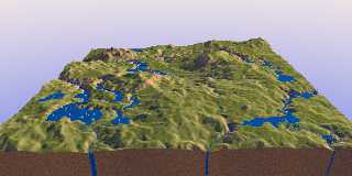
This is looking very realistic indeed. Although some elements are a bit
counter-intuitive, especially lake bottoms, the overall impression is
very convincing. Well done!
--
Thomas
Post a reply to this message
|
|
| |
| |
|
|
|
|
| |
| |
|
|
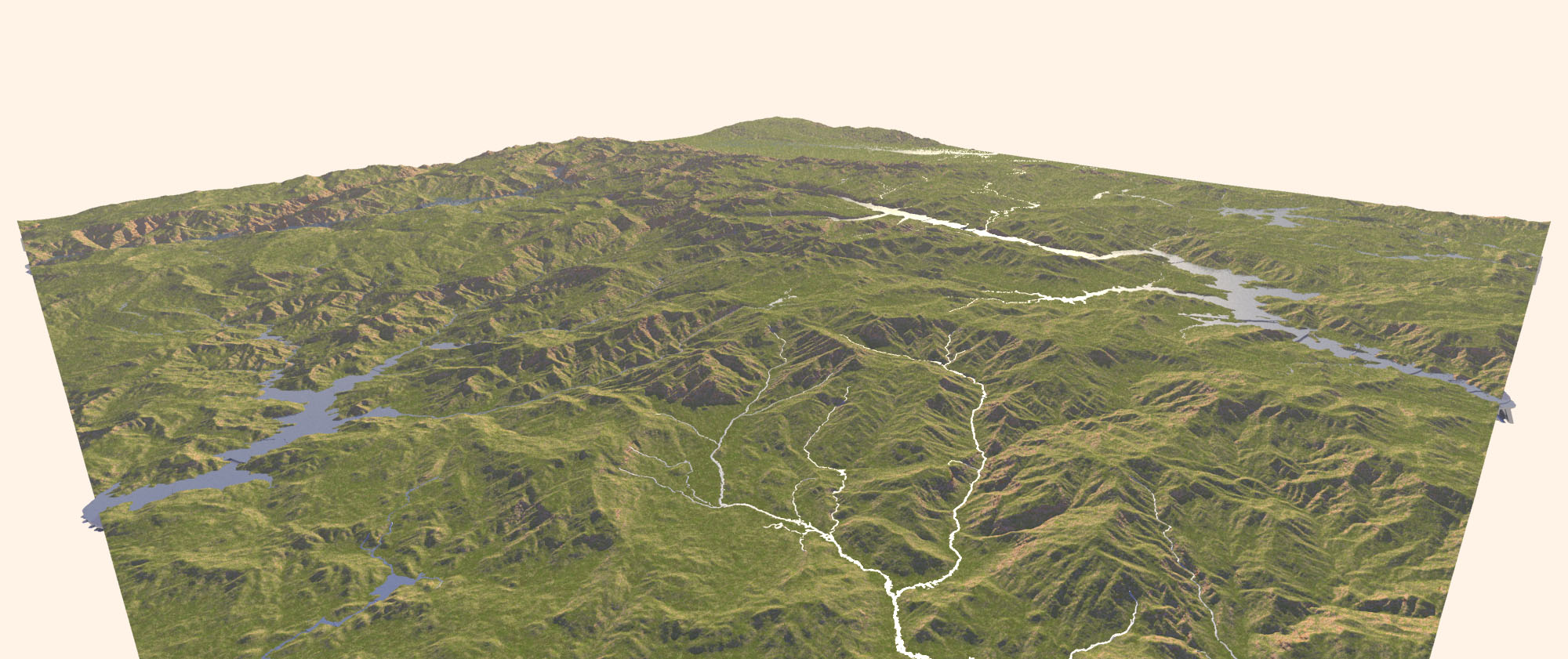
On 25-2-2017 21:09, Kirk Andrews wrote:
> Thanks for sharing those, Thomas. I'm pretty happy with the way the streams are
> flowing on a terrain with erosion factored in!
>
Nice! I especially like those little islands in the streams. Version 4
is doing a good job in any case.
--
Thomas
Post a reply to this message
|
|
| |
| |
|
|
|
|
| |
| |
|
|
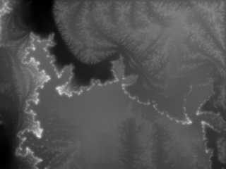
> "Kirk Andrews" <kir### [at] tektonart com> wrote:
>> "omniverse" <omn### [at] charternet> wrote:
>>>
>>> Has me wondering if erosion could be accomplished via difference {} using
>>> likewise cone+sphere stream/lake creation method.
>>
>> Looks like that was something I was trying out, back in 2008. Looks like I was
>> rendering out a flat image of just the rivers to be subtracted from the height
>> map image.
> Sure does mess with my eyes! I turned it upside down, sideways too, and those
> shadows just wouldn't get right for me.
>
> Maybe I'm seeing it wrong but the tributaries appear to begin or end at the
> lower elevations with pooling water at the higher elevations.
>
> Does give the appearance of eroded ground anyhow regardless of how I see it.
>
>
I see it the same. Water accumulating on/flowing toward the highest parts. com> wrote:
>> "omniverse" <omn### [at] charternet> wrote:
>>>
>>> Has me wondering if erosion could be accomplished via difference {} using
>>> likewise cone+sphere stream/lake creation method.
>>
>> Looks like that was something I was trying out, back in 2008. Looks like I was
>> rendering out a flat image of just the rivers to be subtracted from the height
>> map image.
> Sure does mess with my eyes! I turned it upside down, sideways too, and those
> shadows just wouldn't get right for me.
>
> Maybe I'm seeing it wrong but the tributaries appear to begin or end at the
> lower elevations with pooling water at the higher elevations.
>
> Does give the appearance of eroded ground anyhow regardless of how I see it.
>
>
I see it the same. Water accumulating on/flowing toward the highest parts.
Post a reply to this message
|
|
| |
| |
|
|
|
|
| |
| |
|
|
I found some real world height maps. I was sure they were out there, but I was
having trouble actually finding them previously.
If you're interested, I got them from https://earthexplorer.usgs.gov/ (follow
instructions from http://gisgeography.com/free-global-dem-data-sources/)
Post a reply to this message
Attachments:
Download 'water4_usgs.jpg' (322 KB)
Preview of image 'water4_usgs.jpg'
|
|
| |
| |
|
|
|
|
| |
| |
|
|
On 27-2-2017 4:05, Kirk Andrews wrote:
> I found some real world height maps. I was sure they were out there, but I was
> having trouble actually finding them previously.
>
> If you're interested, I got them from https://earthexplorer.usgs.gov/ (follow
> instructions from http://gisgeography.com/free-global-dem-data-sources/)
>
Thanks. Good reminder. I used those data in a distant past indeed... ;-)
--
Thomas
Post a reply to this message
|
|
| |
| |
|
|
|
|
| |
| |
|
|
On 27-2-2017 4:05, Kirk Andrews wrote:
> I found some real world height maps. I was sure they were out there, but I was
> having trouble actually finding them previously.
>
A few other sites of interest:
https://www.ngdc.noaa.gov/mgg/topo/globe.html or
https://www.ngdc.noaa.gov/mgg/global/seltopo.html
http://www.viewfinderpanoramas.org/dem3.html
--
Thomas
Post a reply to this message
|
|
| |
| |
|
|
|
|
| |
| |
|
|
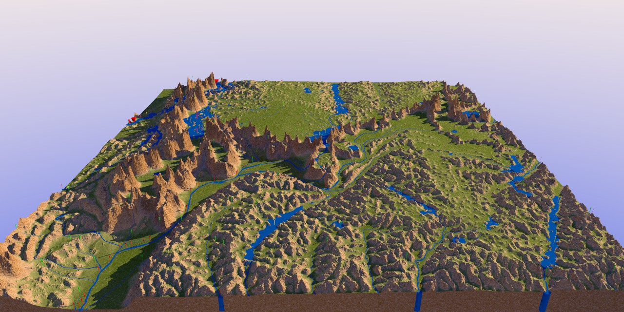
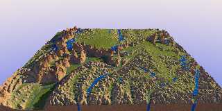
Investigating further into version 4. Attached is (1) a new version of
one of the previous height_fields, with more blur applied; (2) the
rendered landscape with streams. There are a couple of instances where
the ponding is showing its edge when the surface dips too steeply away
(I guess): foreground left and right (look at the shadows).
[I still cannot understand what makes the "water pillars" shown in
previous images. Maybe to do with completely flat surfaces and the
edges? I am not sure where to look in the code to get a true grip on them.]
--
Thomas
Post a reply to this message
Attachments:
Download 'wilbur_weatheredchasm_02.png' (375 KB)
Download 'ka_water4.jpg' (183 KB)
Preview of image 'wilbur_weatheredchasm_02.png'
Preview of image 'ka_water4.jpg'
|
|
| |
| |
|
|
|
|
| |
| |
|
|
Another one.
--
Thomas
Post a reply to this message
Attachments:
Download 'wilbur_bay1_02.png' (1130 KB)
Download 'ka_water4.jpg' (236 KB)
Preview of image 'wilbur_bay1_02.png'
Preview of image 'ka_water4.jpg'
|
|
| |
| |
|
|
|
|
| |
| |
|
|
Am 01.03.2017 um 09:54 schrieb Thomas de Groot:
> Another one.
Somewhere in the process of producing this height map, clearly some
fractal generator was involved.
Post a reply to this message
|
|
| |
| |
|
|
|
|
| |
| |
|
|
On 1-3-2017 15:39, clipka wrote:
> Am 01.03.2017 um 09:54 schrieb Thomas de Groot:
>> Another one.
>
> Somewhere in the process of producing this height map, clearly some
> fractal generator was involved.
>
Excellent, pupil Clipka! :-)
I still have some ancient gif images made long ago when the Earth was
still young. I do not remember what generator was involved; probably
fractrace. I kept them for sentimental reasons.
--
Thomas
Post a reply to this message
|
|
| |
| |
|
|
|
|
| |