Following the discussion p.a-u on how to generate sediment layering
without immediately requiring the use of isosurfaces, I have been
playing a bit with different ideas.
First, in order to focus on something tangible, I got two Real World
examples:
https://geologylearn.blogspot.com/2015/11/sedimentary-structures.html
https://blogs.egu.eu/divisions/ts/2019/12/27/features-from-the-field-bedding-stratification/
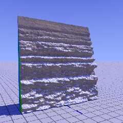
Then, I used Gimp to draw a rough b/w image. This image I loaded into
GeoControl, my old heightfield generator, and exported a .tga image_map
that I could use as height_field in POV.
A tentative result is attached here. Not bad for a first,I think. :-)
Note: Jaime Vives Piqueres is the author of hf2iso. I can recommend it
if you want to play with isosurface landscapes.
--
Thomas
Post a reply to this message
Attachments:
Download 'hf_sedimentary_test.png' (486 KB)
Preview of image 'hf_sedimentary_test.png'
|


