|
 |
Op 10/09/2023 om 18:01 schreef Bald Eagle:
>
> With regard to TdG's interest in erosion, I was thinking about doing a quick
> test with an image map converted to a height_field.
>
> The only problem here is that I don't recall if there was a way to edit the
> pixel data in the image_map, or in the height_field, or to somehow use a
> function {} or a 2D array to create an image or heightfield...
>
> Or maybe a way to add/subtract / overlay onto the base image.
> I can't use arrays in functions, otherwise I could do image_map {function
> {array}}
>
> It would be useful to not have to load an image, convert that to an array, use
> that array to create a mesh, then use the algorithm I'm experimenting with to
> edit the mesh.....
>
> Does anyone have any ideas?
>
> - BW
>
Real Time is binding me hands and feet, so a belated comment so far.
What I am personally looking for / interested in is not so much the
generation of natural-looking heightfields in terms of erosional
patterns like mountains and valleys which is provided by e.g. World
Machine. In itself it is an interesting topic and I remember (but cannot
find again) a series of tests some years ago where the drainage patterns
on in the heightfields were used to generate down-flowing rivers using a
trace function. I must have a whole collection of examples somewhere
under the dust but to date I have not been able to find those.
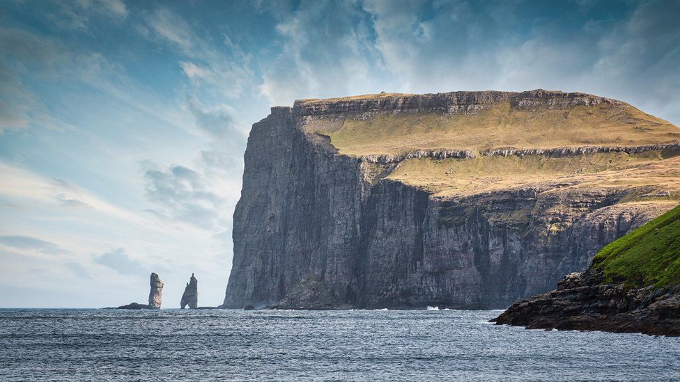
What I am /really/ interested in is the rockface erosion in cliffs and
such which enhance the natural aspect of any mountain or landscape. As
an example I attach a photograph of the Faroe Islands showing a cliff
face, but what you can see are those (sub-)horizontal layers of more or
less "competent" (= hard/soft) rocks, in the cliff and in the overlying
landscape. They account for regions where the rock faces are more or
less overhanging. This is impossible in classical heightfields but easy
to achieve with isosurfaces of course.
Could we somehow achieve something similar using functions in POV-Ray,
without the help of isosurfaces? That would be my question.
--
Thomas
Post a reply to this message
Attachments:
Download 'faroe islands.jpg' (112 KB)
Preview of image 'faroe islands.jpg'
|
|