I have taken up again my Paleo-Earth project. I wanted to thoroughly
test out Wilbur (http://www.fracterra.com/wilbur.html) for this and I am
rather satisfied.
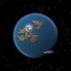
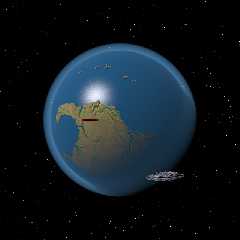
These images are a first approximation of what I want to obtain. They
depict Earth during approximately the Middle Silurian period, about 420
million years ago.
The equatorial view shows the making of Euramerica: the collision of the
Laurentia-Greenland and the Baltica continents, closing the Iapetus
Ocean and forming the Caledonian mountain range between them,
approximately N-S here in the centre of the image. To the north, and
separated by the Ural Ocean, is the Siberia Continent, slowly moving
southwards.
The polar view shows Gondwanaland, the huge continent formed by South
America, Africa, Australia and India. Obviously, there are some problems
around the pole to solve ;-)
In space, the time travel transport vehicle is shown.
--
Thomas
Post a reply to this message
Attachments:
Download 'paleo earth_silurian01.png' (185 KB)
Download 'paleo earthsilurian02.png' (172 KB)
Preview of image 'paleo earth_silurian01.png'

Preview of image 'paleo earthsilurian02.png'

|


![]()