|
 |
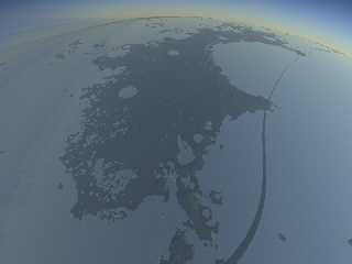
Here are some pictures of the moon.
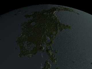
This is the island of Jura, looking north. (Normally visible on the
north-west limb of the near side of the moon.) It's about 600km long,
making it about two-thirds the size of the British Isles.
This is a copy of a rendering I did a couple of years ago, but the main
interesting thing here is that rather than using a massive mesh for the
terrain, it's using the plugin code I posted to .general the other day
to read the data directly out of NASA PDS files (a 6GB data set!). There
should be some procedural noise overlayed on top, so it gets a bit bland
when you get up close, but it's working really well.
However, as you can see, I suck at media; the sky is dire. Last time I
made it work by brute force and ignorance, just increasing the samples
to about 30 and living with achingly long rendering times. I want to do
better this time.
(The weird stripe is an artifact of the *sky*, not the terrain. I assume
it's a sampling glitch of some kind. No idea what's going on there. To
prove it, I enclose another picture with the sky turned off, and you can
see the ocean is fine.)
My sky media is:
media {
method 2
ratio 1
samples 10
scattering {
RAYLEIGH_SCATTERING
color 2.3 * Rayleigh_Colour / Atmospheric_Scale
extinction 1
}
density {
function { Rayleigh_Density_Function(x, y, z).x }
}
}
The density function calculates atmospheric density with altitude.
Any suggestions?
--
┌─── dg@cowlark.com ─────
http://www.cowlark.com ─────
│ "There is nothing in the world so dangerous --- and I mean *nothing*
│ --- as a children's story that happens to be true." --- Master Li Kao,
│ _The Bridge of Birds_
Post a reply to this message
Attachments:
Download 'newmoon.jpg' (54 KB)
Download 'newmoon.nosky.jpg' (93 KB)
Preview of image 'newmoon.jpg'

Preview of image 'newmoon.nosky.jpg'

|
 |


![]()