|
|
|
|
|
|
| |
| |
|
|
|
|
| |
| |
|
|
Because catenary bridges are way cooler than power lines. :)
Post a reply to this message
Attachments:
Download 'catenarybridge.png' (1054 KB)
Preview of image 'catenarybridge.png'
|
|
| |
| |
|
|
|
|
| |
| |
|
|
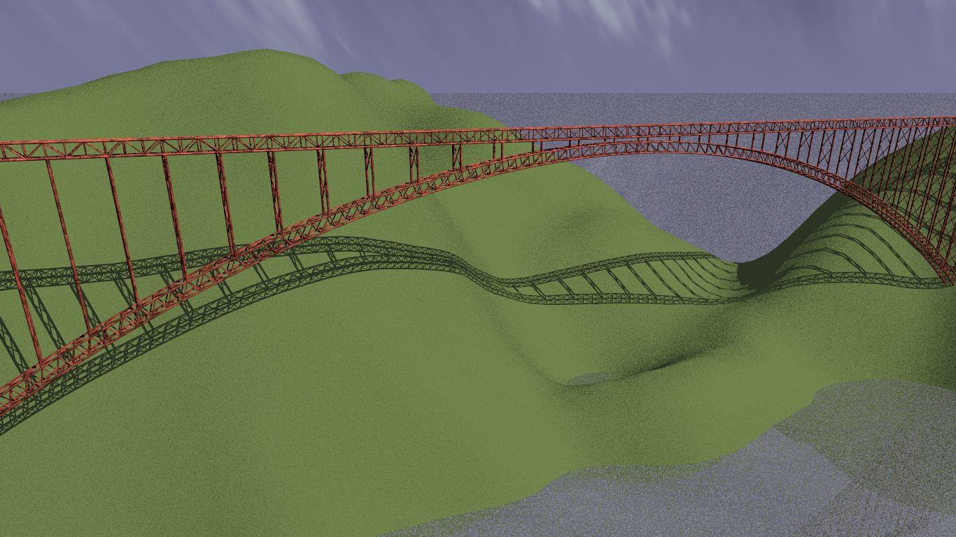
Slight progress before packing it in for the night.
Adjusted scale of struts, added cross-braces, red iron oxide paint texture,
added quick heightfield mountains, water, sky sphere.
Post a reply to this message
Attachments:
Download 'catenarybridge.png' (1578 KB)
Preview of image 'catenarybridge.png'

|
|
| |
| |
|
|
|
|
| |
| |
|
|
On 06/03/2016 11:35 PM, Bald Eagle wrote:
> Slight progress before packing it in for the night.
>
> Adjusted scale of struts, added cross-braces, red iron oxide paint texture,
> added quick heightfield mountains, water, sky sphere.
>
Cool. I've always enjoyed views of such bridges. The New Rivers Gorge
bridge as an example.
Bill P.
Post a reply to this message
|
|
| |
| |
|
|
|
|
| |
| |
|
|
William F Pokorny <ano### [at] anonymous org> wrote:
> Cool. I've always enjoyed views of such bridges. The New Rivers Gorge
> bridge as an example.
>
> Bill P.
Thanks :)
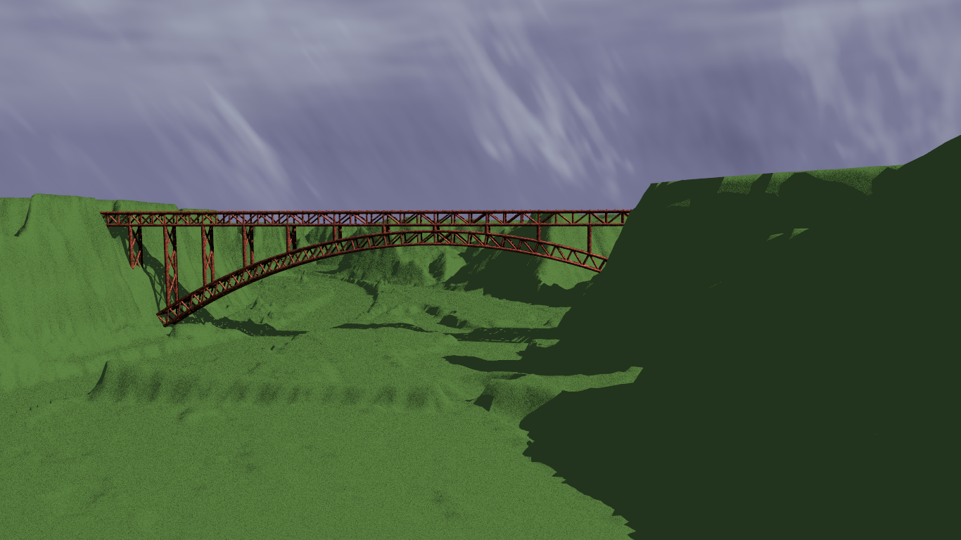
I actually managed to grab the geo data from USGS, convert it into a png, and
then a heightfield, and once I got it all scaled and un-lost myself in the
aerial view, I managed to get things reasonably aligned.
Still needs some scaling and repositioning, and then it's mostly a matter of
working on the textures, seeing what I can do with plants again :O and all of
that skilled stuff that takes forever. :D org> wrote:
> Cool. I've always enjoyed views of such bridges. The New Rivers Gorge
> bridge as an example.
>
> Bill P.
Thanks :)
I actually managed to grab the geo data from USGS, convert it into a png, and
then a heightfield, and once I got it all scaled and un-lost myself in the
aerial view, I managed to get things reasonably aligned.
Still needs some scaling and repositioning, and then it's mostly a matter of
working on the textures, seeing what I can do with plants again :O and all of
that skilled stuff that takes forever. :D
Post a reply to this message
Attachments:
Download 'catenarybridge.png' (812 KB)
Preview of image 'catenarybridge.png'
|
|
| |
| |
|
|
|
|
| |
| |
|
|
On 5-6-2016 4:51, Bald Eagle wrote:
> William F Pokorny <ano### [at] anonymousorg> wrote:
>
>> Cool. I've always enjoyed views of such bridges. The New Rivers Gorge
>> bridge as an example.
>>
>> Bill P.
>
> Thanks :)
> I actually managed to grab the geo data from USGS, convert it into a png, and
> then a heightfield, and once I got it all scaled and un-lost myself in the
> aerial view, I managed to get things reasonably aligned.
>
> Still needs some scaling and repositioning, and then it's mostly a matter of
> working on the textures, seeing what I can do with plants again :O and all of
> that skilled stuff that takes forever. :D
>
Good work!
Maybe the USGS data are a bit too /global/ for this scale? A bit of
extra roughness added to the png should do the trick.
--
Thomas
Post a reply to this message
|
|
| |
| |
|
|
|
|
| |
| |
|
|
Thomas de Groot <tho### [at] degrootorg> wrote:
> Good work!
Thanks - though it was just a quick mock-up.
> Maybe the USGS data are a bit too /global/ for this scale?
Why yes, as I found out.
The only data set I can find of that area is a 1 sec arc that covers something
like 69 miles square.
Once I figured out just HOW BIG the map was, corrected the scale, oriented
myself, found my way through it, and zoomed WAY WAY in to where I actually
wanted to be.... :O
I had to convert the original color png to a 16-color, and that brought out all
the elevation data, but at that resolution, it looks like Hell.
> A bit of extra roughness added to the png should do the trick.
>
> --
> Thomas
Any recommendations for data sources, fixing up what I've got?
"extra roughness"?
Post a reply to this message
|
|
| |
| |
|
|
|
|
| |
| |
|
|
On 5-6-2016 22:40, Bald Eagle wrote:
> Thomas de Groot <tho### [at] degrootorg> wrote:
>
>> Good work!
>
> Thanks - though it was just a quick mock-up.
>
>> Maybe the USGS data are a bit too /global/ for this scale?
>
> Why yes, as I found out.
> The only data set I can find of that area is a 1 sec arc that covers something
> like 69 miles square.
> Once I figured out just HOW BIG the map was, corrected the scale, oriented
> myself, found my way through it, and zoomed WAY WAY in to where I actually
> wanted to be.... :O
> I had to convert the original color png to a 16-color, and that brought out all
> the elevation data, but at that resolution, it looks like Hell.
Yes, those are huge. It has been more than 15 years ago when I last
played with USGS data (I must have a couple of CD-ROMs with DEM data
gathering dust somewhere) and they are great for overviews but not
detailed enough for close up. We always want better of course ;-)
>
>> A bit of extra roughness added to the png should do the trick.
>>
>> --
>> Thomas
>
> Any recommendations for data sources, fixing up what I've got?
> "extra roughness"?
I think I miscalculated here :-) Now I seem to remember that the png are
processed elevation data, not something you can modify out of hand. Just
a thought: use the png inside a function with some randomisation?
However, I am afraid that would totally change the resulting landscape.
--
Thomas
Post a reply to this message
|
|
| |
| |
|
|
|
|
| |
| |
|
|
That 15 (or 20) years just blinks by, doesn't it?
> Just
> a thought: use the png inside a function with some randomisation?
Now there's something I wouldn't have thought of - or even thought I could do.
:O
I'll try to dig up some code to do that when I get back in tonight.
I tried blurring it, but that didn't work out so well.
Thanks :)
Post a reply to this message
|
|
| |
| |
|
|
|
|
| |
| |
|
|
On 6-6-2016 13:11, Bald Eagle wrote:
>
> That 15 (or 20) years just blinks by, doesn't it?
Yes, it does. The memory is diffuse about the matter however.
>
>> Just
>> a thought: use the png inside a function with some randomisation?
>
> Now there's something I wouldn't have thought of - or even thought I could do.
> :O
> I'll try to dig up some code to do that when I get back in tonight.
>
> I tried blurring it, but that didn't work out so well.
>
> Thanks :)
>
>
I'll try to dig through the accumulated dirt to find something useful.
Don't hold your breath though ;-)
--
Thomas
Post a reply to this message
|
|
| |
| |
|
|
|
|
| |
| |
|
|
On 6-6-2016 13:28, Thomas de Groot wrote:
> I'll try to dig through the accumulated dirt to find something useful.
> Don't hold your breath though ;-)
>
This is something you can play with as an example:
#declare F_HF_01 =
function {
pigment {
image_map {
tga "MyImage.tga" //gamma 1.0
map_type 0
interpolate 2
}
warp {repeat x}
warp {repeat y}
rotate 90*x
scale 50
warp {
turbulence 0.5
octaves 2 //[6]
lambda 1 //[2]
omega 0.2 //[0.5]
}
scale 1/50
}
}
#declare P =
function {
F_HF_01(x, y, z).hf
- f_hetero_mf(x,y,z, 0.8, 2, 5, 0, 0.9, 2)*0.3
//- f_noise3d(x,y*2,z)*0.5
- f_agate(x,y,z)*0.01
}
height_field{
function 500, 500 {P((x-0.5)*MyXscale+0.5, 0, (y-0.5)*MyZscale+0.5)}
translate <-0.5, 0, -0.5>
scale <MyScale>
pigment {MyPigment}
}
This is from an old test scene of mine, partly based on an example by
Mike Williams.
--
Thomas
Post a reply to this message
|
|
| |
| |
|
|
|
|
| |
|
|