|
 |
Hi all,
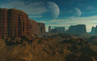
attached is an updated land test for my landscape generator. This one took 4
hours 33 min to render on a P4 1.8. I haven't updated the clouds yet as I'm
still working on a set of good density definitions for high, mid and low
altitude clouds. However I thought I'd post this image as it shows two new
features, moons and rocks.
As others have guessed the land form is a height field. It's a function
image based height field. To speed up the parsing times the height field is
tiled with diminishing resolution as each tile gets further away from the
camera. Another algorithm controls the number of tiles so that they are only
generated if part of the tile falls within the viewing plane.
Post a reply to this message
Attachments:
Download 'land2.jpg' (117 KB)
Preview of image 'land2.jpg'

|
 |
|
 |
I find it really improved since last time.
The moons look really nice, especially the shadows that take the
atmosphere's color. Maybe the moons' surface texture would require some
more work, they look too much like a basic POV texture, maybe some
normal would do the trick.
An other thing is the ground on first plan, I think it looks too smooth,
this is due to the height field I guess, but having a stone-like normal
for this would help.
Last thing is the top of the cliff, it looks like there is a heap of
earth on top, while I would expect more stone layers getting smaller and
smaller. But anyway there is a little problem of color transition
between the cliff and the very top.
However, it's really great, and I hope you'll release the source when
you're done.
JC
Nathan O'Brien wrote:
> Hi all,
>
> attached is an updated land test for my landscape generator. This one took 4
> hours 33 min to render on a P4 1.8. I haven't updated the clouds yet as I'm
> still working on a set of good density definitions for high, mid and low
> altitude clouds. However I thought I'd post this image as it shows two new
> features, moons and rocks.
>
> As others have guessed the land form is a height field. It's a function
> image based height field. To speed up the parsing times the height field is
> tiled with diminishing resolution as each tile gets further away from the
> camera. Another algorithm controls the number of tiles so that they are only
> generated if part of the tile falls within the viewing plane.
>
>
>
Post a reply to this message
|
 |


![]()