 |
 |
|
 |
|
 |
|  |
|  |
|
 |
|
 |
|  |
|  |
|
 |
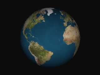
I've been wanting to render an Earth image so I found Micha's and
then downloaded the JPG image and bump files from the recommended
site and converted them to PNG and TGA, according to the format
required by Micha's include, took out the comments, and it produced
this! I realize that I haven't hardly done anything, but it looked so nice
I just had to post it!
Thanks, Micha! Now I'm going to try and do a rotating animation.
There's some kind of trick involved in rotating with an image map,
isn't there? I'm a newbie, so I'll probably mess it up any way I can.
Thanks for looking and reading!
miker
Post a reply to this message
Attachments:
Download 'earth.jpg' (20 KB)
Preview of image 'earth.jpg'

|
 |
|  |
|  |
|
 |
|
 |
|  |
|  |
|
 |
3e0db68e@news.povray.org...
> Thanks, Micha! Now I'm going to try and do a rotating animation.
> There's some kind of trick involved in rotating with an image map,
> isn't there?
AFAIK there is no trick involved in rotating with an image map,
it's simply:
object { earth
rotate y*clock*360
}
Bye
Txemi Jendrix
http://www.txemijendrix.com
Post a reply to this message
|
 |
|  |
|  |
|
 |
|
 |
|  |
|  |
|
 |
I like to rotate it a little along the z axis also, since the earth is
tilted. For example,
object {Earth rotate (clock * 360) * y rotate -10 * z}
The z rotation is for the tilt of the earth on its axis. Technically, the
value should be -23.5 degrees.
Also, if anyone's interested, I made a .png earth image with transparent
oceans, so you can give the water a different finish than the land.
Regards,
Dave Blandston
Post a reply to this message
|
 |
|  |
|  |
|
 |
|
 |
|  |
|  |
|
 |
Nice. You should add clouds for realism.
- Slime
[ http://www.slimeland.com/ ]
Post a reply to this message
|
 |
|  |
|  |
|
 |
|
 |
|  |
|  |
|
 |
Slime wrote:
Nice. You should add clouds for realism.
********
Thanks for responding, guys. They have a cloud map, too! I've got
the thing animated now. It looks pretty good but it's got what I believe
is called "artifacts" in it, which makes the surface jitter a bit in spots.
The animation is just a plain rotation. I think my next trick is to move
the camera in for a close-up, sort of like I was landing a spaceship.
When I get close enough to Lake Monroe, I'd like to use some DEM
bumps and topograpical maps that I've got.
Thanks, miker
Post a reply to this message
|
 |
|  |
|  |
|
 |
|
 |
|  |


![]()